
Day 30: Getting ‘Lost’ Before Hitting the Campaign Trail in New Hampshire
April 18, 2021
Day 28: Motoring Through Massachusetts to My Great Aunt’s Famous House
April 16, 2021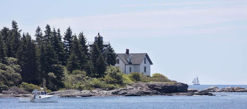
Most recently updated on March 29, 2024
Driven on July 21, 2023
Originally posted on April 17, 2021
An interesting thing happens as you head from Salem, Massachusetts, toward the Maine coastline.
You have to travel through a little chunk of New Hampshire before you get there.
You hit that state line about 40 minutes after departing from Salem as you cruise northbound on Interstate 95.
This territory is a 13-mile-wide coastal section of New Hampshire that wedges itself between Massachusetts and Maine. That 13-mile shoreline is the shortest of any in the 23 states that border an ocean.
I’m guessing this strip of land belongs to New Hampshire for a simple reason. The people of this state wanted access to the Atlantic Ocean.
The most populous coastal town is Portsmouth, a community of 23,000 people near the Maine border that is 87 percent white. We’re going to see a lot of that type of demographic on the drive today.
The Abenaki tribes lived in this region for 12,000 years. It was first settled by English colonists who started a fishing village here in 1623. It was the first European settlement in New Hampshire.

The town was originally named Strawbery Banke because of the abundance of wild berries that grew along the river. It was protected by Fort William and Mary.
The port prospered early due to its ideal location for upstream trade for the fishing, lumber and shipbuilding industries. Slaves were first brought to work at the port in 1645.
The town was incorporated in 1653 and renamed after Portsmouth, England.
In December 1774, Paul Revere made a famous ride here, four months before his midnight ride in Boston. In this instance, Revere rode to Portsmouth to warn citizens of approaching British warships that intended to seize gunpowder and munitions. The town’s residents responded by seizing Fort William and Mary from the six British troops guarding it and thwarting the planned attack.
The port industry declined in the second half of the 1800s as upriver mill towns prospered on their own.
In the first half of 1900s, submarines were built and repaired in Portsmouth. Only the repair end of that industry remains intact.
Today, Portsmouth is primarily a center for agriculture and light manufacturing as well as a resort region. In April 2022, President Joe Biden visited the town to tout the $1.6 million the port had received from the White House’s infrastructure plan for dredging and widening.
There’s some interesting historic sites here.
The USS Albacore is located in a park in town. The research submarine was retired in 1972, but you can still take a tour of that vessel at the site. There’s a Memorial Garden that honors the people who served on the Albacore and other submarines.
There’s also the John Paul Jones House. The home was built in 1758. The famous Revolutionary War admiral known for defeating British ships off the coast of England in 1779 only rented a room in the house during 1777. Nonetheless, the museum, which was established in 1920, bears his name. The purpose of the museum is to honor the men, women and children who have lived in Portsmouth since its founding.
There’s also the Strawbery Banke Museum, named after the town’s original title. The 10-acre site opened in 1965 with the mission of retaining the region’s history.
The Maine Way
As soon as you cross the Piscataqua River you enter the state of Maine.
The population of the Pine Tree State is the oldest and least diverse of all the states.
Maine’s 35,379 square miles places it 39th among all states, but it is still the largest of all the New England states.
It ranks 42nd in population with nearly 1.4 million residents. Its most populous city, Portland, has only 68,000 residents.
That population is 92 percent white, one of the highest percentages of any state. The median age is close to 45 years, number one among states. The median annual household income is $68,000.
The state is home to West Quoddy Head, a peninsula with a lighthouse that, despite its name, is the easternmost point in the United States. Maine also has Lubec, the easternmost town in the continental United States, and Eastport, the easternmost city.
The first European settlement was established by French explorers in 1604. Much of the state was blockaded by the British during the War of 1812.

Maine was originally part of the Commonwealth of Massachusetts. It became a state in 1820 as part of the Missouri Compromise. That legislation allowed Missouri to enter the Union as a slave state in exchange for Maine becoming a free state.
In the 1800s, Maine was the top region for building wooden ships due to its availability of lumber and its long Atlantic coastline. That industry faded when steel became the primary shipbuilding material.
The ocean waters are still a primary economic driver. Among other things, Maine is by far the top producer of lobsters with Massachusetts being a distant second.
Its top agricultural crops include blueberries, poultry, eggs, cattle, dairy, apples, maple syrup and maple sugar. Its chief manufacturing products are paper, lumber and wood products. Tourism also plays a role, especially with sport hunting, sport fishing and camping. Maine has the largest moose population among the lower 48 states with an estimated 60,000 to 70,000. Moose hunting is popular with 50,000 people applying every year for the 2,000 to 3,000 moose hunting permits typically issued.
There’s been some political debates in the state in recent years.
In 2019, Maine Governor Janet Mills signed legislation that made Maine the first state to ban Styrofoam food containers. That law was supposed to take effect on January 1, 2020, but its implementation was delayed until July 1, 2020, due to the demand for plastic bags during the COVID-19 pandemic.
In March 2020, Maine voters rejected a measure that would have repealed a new state law that eliminates religious and philosophical exemptions to mandatory vaccinations.
A variety of things to see in our country’s most northeastern state. To do that, we will hug the Maine coastline until we reach an artists’ colony that is the farthest distance on this journey from our home base of San Francisco.
———————————————-
Just 20 minutes past the state line on Interstate 95 sits the town of Ogunquit.
This community of 1,200 people is a coastal hamlet with a three-mile-long sandy beach.
Native tribes lived and fished here for centuries. Ogunquit means “beautiful place by the sea” in the Abenaki language.
The first European settlers arrived in the 1620s, the same decade the Pilgrims landed at Plymouth Rock.
The first sawmill was built in 1686. Early fishers dug a channel to protect their boats from Atlantic storms. Perkins Cove was the result.
Eventually, shipbuilding became the main industry. Facilities along the Ogunquit River constructed schooners, brigs and the well-known Ogunquit Dory.
In the late 1800s, artists discovered this picturesque community. The Ogunquit Art Colony was established in 1898. Seaside hotels were built to accommodate the summer crowds.
Today, Ogunquit is still a haven for artists, summer vacationers and sport fishing. In fact, in a typical summer, the population of the town can swell to more than 75,000.
The community also developed into a destination for LGBTQ tourists. Many visitors fly into the airport in Portland less than an hour north. The town has a number of LGBTQ-owned bars, restaurants and hotels.
—————————————-
From Ogunquit you travel another 20 minutes along the shoreline on northbound Highway 1 to reach the hamlet of Kennebunkport.
The seaside town of 5,700 people wasn’t well known until 1989. That’s when George H. W. Bush became president and the family’s beach home here became a retreat from the duties of the White House.
European settlers first established the town in the 1620s. It was incorporated in 1653 and named Cape Porpus.
The first sawmill was built in 1681. However, by 1689, the town had lost most of its population due to disputes with local tribes.
It was settled again by Europeans in 1718 and named Arundel. In 1821, the town was renamed Kennebunk Port after the river that flows into it.
The economy centered on lumber, trade and shipbuilding. The ship industry lasted until 1918 when the need for larger vessels proved too much for the town’s smaller port.
Manufacturing was also a livelihood. In 1838, a cotton factory made use of the river’s water power to manufacture products. Other factories followed, including those that produced thread, shoe laces, shoes and other items.
In the 1870s, the town developed as a summer tourist retreat with hotels and homes along the coast. A railroad line built in 1872 made it easier for urban dwellers to travel here.

The Bush family compound in Kennebunkport, Maine. Photo by Roadtrippers.
One of the people who flocked to this shoreline was George Herbert Walker, the grandfather of President Bush. He built a summer home on Walkers Point in 1902.
President Bush purchased the property from an uncle in 1977. Both he and his son, George W. Bush, used the house as a getaway when they were president. Both invited foreign leaders to the home during their terms.
Closer to downtown is the First Families Kennebunkport Museum operated by the Kennebunkport Historical Society that depicts the Bush family’s life in the town.
There is also a Seaside Trolley Museum, the world’s oldest and largest museum of public transportation. The facility, which opened in 1939, houses 320 vehicles from trolleys to railroad cars to buses. It also has street cars from almost all the major cities in the country.
The Rachel Carson National Wildlife Refuge is along Kennebunkport’s coastline. The 14,600-acre preserve was established in 1966 to protect salt marshes and estuaries for migratory birds. It’s named after Rachel Carson, who wrote a number of ecological books that included “Silent Spring” in 1962. The book warned of the dangers of environmental pollution. Among other things, it inspired legislation to control the use of pesticides.
Today, Kennebunkport remains a fishing harbor along with being a summer haven for the upper class. It’s listed as 93 percent white with an annual median household income of $88,000.
—————————————–
Portland, Maine, has literally risen from the ashes more than once.
The community of 68,000 people is a half-hour up the coast from Kennebunkport and sits on a peninsula on the edge of Casco Bay. Its location technically makes Portland the closest U.S. port to the European continent.
Portland is the most populous city in Maine. Its 68,000 residents make the town the fourth smallest community in the country that tops its state in population.
The first Anglo settlement was established in 1633. The town, however, was destroyed by native tribes in 1676 and again by French forces in 1690. The community was also heavily damaged during the Revolutionary War.
Each time, the residents rebuilt their community.
The town became a shipping center after the Revolutionary War. The Grand Trunk Railway to Montreal was completed in 1853. It was North America’s first international railroad. With it, Portland quickly developed into a major ice-free port for Canadian goods.
In the 1800s, the Portland Company manufactured 600 steam locomotives and 160 other transportation vehicles. The nation’s first chewing gum factory was built here in the 1850s. The town shifted to being a rail hub in 1911 when five rail lines were merged.

The harbor in Portland, Maine. Photo by Public Domain Pictures.
Since the 1990s community leaders have been revitalizing the downtown sector. The Old Port waterfront has working fishing wharves as well as old warehouses that have been converted into restaurants and shops. There’s also the 78-acre Eastern Promenade along Casco Bay.
Portland remains the state’s main port and its financial center. The port is still the eastern terminus for the Portland-Montreal oil pipeline. It’s also been the home of the Portland Fish Exchange daily auction since 1986.
The region here is also getting involved in a new type of agriculture.
Work has begun on a “vertical farming” facility in Westbrook, a town adjacent to Portland. A 6-floor, 75-foot-tall complex is under construction that will house an indoor farm. It’s scheduled to open in mid-2024.
It’s one of at least 10 in the planning stages now across the country. They will be modeled after the vertical farm now operating in Jackson, Wyoming. The U.S. vertical farming industry is expected to top $3 billion in 2024.
A CBS Sunday Morning report in May 2022 detailed how these rotating rows of crops are grown indoors using little soil and water. They are becoming more cost efficient due to the decreasing cost of LED lights. The idea is to produce lettuce, tomatoes and other plants in places where the growing season is short.
In Portland, the vertical farmers plan to grow lettuce and other greens using the hydroponic technology. They expect to grow 2 million pounds of produce per year on a half-acre footprint. The food will be sold locally, saving in truck and other transport costs.
The school district in Portland is also a major participant in an educational movement growing across the nation.
Portland Public Schools has embraced an outdoor learning initiative where schoolchildren spend at least part of their day having classes outside. Sometimes on campus and sometimes in the woods.
Brooke Teller, the district’s outdoor learning coordinator, told CBS Sunday Morning in March 2021 that the school system had 156 outdoor learning sites at its 17 buildings. In March 2022, it was one of five Maine school districts to receive $250,000 from the state to bolster outdoor learning.
The CBS Sunday Morning story noted that supporters of the program pointed to the educational benefits of outdoor learning as well as its ability to reduce the risk of COVID-19 spread. Outdoor education, in fact, was utilized in the United States as the nation began to emerge from the 1918 flu pandemic as well as earlier tuberculosis outbreaks.
In June 2022, the governor announced a statewide outdoor learning initiative that will involve 1,000 Maine students. So far, 16 grants have been awarded to organizations and facilities to provide these student experiences.
The movement also receives assistance from Green Schoolyards America, a program that is helping educators transform asphalt-covered grounds into green spaces where children can study and learn outdoors.
One place for a potential field trip here is the Portland Head Light in nearby Cape Elizabeth. It’s the oldest lighthouse in Maine. It opened in 1792. The 72-foot tower at one time used whale oil to power its 16 lamps. The lighthouse suffered extensive damage from waves during the strong storm that hit the northeastern coast in late December 2022, but the landmark still held its annual grand opening in September 2023.
Portland is also the birthplace of author Stephen King, who wrote “Carrie,” “It,” and “The Shining,” among other horror novels. King still lives in Maine in a home in Bangor, two hours north on Interstate 95.
Portland is also the hometown of a number of well-known actors. Among them are Anna Kendrick, Linda Lavin, Andrea Martin and Judd Nelson.
The Power of Water
Water has always fueled the economy of Yarmouth.
This community of 6,100 people just 12 miles north of Portland has had a surprisingly strong industrial sector for the past two centuries.
The Wabanaki were among the tribes that occupied this region. The first Europeans settled here in the 1630s. They departed in 1676 due to King Philip’s War, which pitted local tribes against English soldiers.
Settlers returned in 1679, only to be driven away in 1689 by more warfare.
The area remained relatively deserted until another group of settlers put down roots in 1715.
The town they established sat along the Atlantic Coast and the Royal River that empties into Casco Bay, so it was a natural harbor.
Ships were built at four major shipyards from 1818 to the 1870s, when demand finally diminished.
There are four waterfalls along the Royal River near town that were utilized for hydro power. The first saw mill was built in 1674 at First Falls. Between 1674 and 1931, there were 57 saw, grain, pulp, cotton and other mills that operated at various times.
In 1874, the Forest Paper Company took over a mill, eventually expanding the site to 10 buildings over 10 acres. By 1911, it was the largest mill of its kind in the world, employing 250 people. It used 16 rail spurs to process 80 tons of pulp a day. The mill closed in 1923 after Swedish pulp became cheaper.

Eartha, the world’s largest revolving globe, in Yarmouth, Maine. Photo by The Great American RoadTrip Forum.
Highway 1 came through in 1948 and the coastal Interstate 295 was finished in 1961. Both boosted the town’s economy, although residents opposed I-295 because it separated the waterfront from the rest of the community.
There are still a number of factories along the river banks today. They include paper, shoe and brick complexes as well as the Yarmouth Electric Company that was established in 1911. Fishing and lobster industries also remain strong.
Yarmouth’s residents, 93 percent of whom are white, seem to do pretty well. The median annual household income is $108,000, although the poverty rate is listed at 11 percent.
There are more than a dozen sit-down restaurants as well as the Yarmouth Clam Festival in July that draws 120,000 people in a typical year.
The town is also the headquarters of DeLorme, a navigation, GPS and satellite tracking company. It was founded in 1976. The company’s map store was closed in 2016, but the new Swiss owners, Garmin, say they’ll continue to sell maps at retail stores. The company’s focus, however, has shifted to being an informational service for scientific and professional markets.
The company’s offices feature Eartha, the world’s largest revolving globe. It’s 41 feet in diameter and has been in the lobby since 1998.
———————————
The town of Freeport, just 10 minutes up Interstate 295 from Yarmouth, has also had an economic history closely linked to water.
However, the best known business in this town of 8,700 residents is a popular brand of outdoor clothing.
This region along the Harraseeket River was first settled around 1700 and officially established in 1789.
The river waters made the settlement a conducive place for the timber industry. Lumber from that time was used primarily for ship masts. The ship building trade grew after the Revolutionary War.
The rivers also provided power for saw and grist mills. Fishing, canning and farming were also important components of the economy.
The railroad arrived in 1849 and the manufacturing industry started to gain traction in the late 1800s.
In the early 1900s, one of the most successful enterprises in Freeport got its start.
The business was established in 1912 when Leon Leonwood Bean, a 40-year-old hunter and fisher, used one room out of his brother’s house to start a mail order company he called L. L. Bean.
There was only one product at first. It was a waterproof “duck boot” called the Maine hunting shoe or sometimes the “Bean boot.” The first batch, however, had a design flaw and 90 percent of those initial customers returned the product. Bean reimbursed all of them.

The L. L. Bean flagship store in Freeport, Maine. Photo by Wikipedia.
Bean then redesigned the shoe and used the addresses of everyone in Maine with a hunting license for his customer list.
Sales went well enough that Bean opened his flagship store in Freeport in 1917. In 1924, L. L. Bean introduced the Maine Duck Hunting Coat.
Eleanor Roosevelt visited the shop in 1933. A women’s department was established in 1951. The first store outside Maine opened in 2000 in McLean, Virginia.
The business has grown to more than 50 L. L. Bean retail stores in 17 states employing more than 5,000 full-time employees. The company’s online enterprise is a major component in the company’s $1.6 billion in annual sales.
The company has also “Bootmobiles,” a fleet of cars with a giant Maine hunting shoe on top that have traveled more than 350,000 miles over the years.
The 200,000-square-foot flagship store in Freeport has 3 million visitors in a typical year.
Since 1951, it had been open 24 hours a day 365 days a year. Because it was always open, the store had no locks on its doors.
That streak came to an end in March 2020 when the store closed due to the COVID-19 pandemic. Online sales continued and the store doors reopened in early June 2020.
During a visit in July 2023, we got a look at the sprawling campus here. There are a half-dozen specialized sections that are interconnected into one large 2-story building. The hunting and fishing department melds into the clothing area, which transitions into the camping area.
The hunting and fishing sector had all sorts of fishing poles upstairs with a wide selection of rifles and shotguns on the first floor. There was even a service window to drop off guns to be cleaned or repaired. In the corner was a computer where you could renew or purchase hunting and fishing licenses. It was right next to the clay pigeon target shooting equipment.
On this day, business was brisk. There were 7 registers ringing up purchases in the clothing sector with another 5 registers going in the hunting and fishing area. Both departments still had long lines.
Perry and Rachael Dufresne from Phoenix, Arizona, were here, although they weren’t buying anything. They brought their 4 children, ages 1 to 7, to see the place and play on the large L. L. Bean shoe replica outside the clothing department. Perry grew up in Maine while Rachael is from Southern California. Perry has been to the flagship store many times. This was his wife’s second visit. The kids had never seen it.
“This is as Maine as it gets,” Perry said outside the clothing store.
Freeport is also home to the “Desert of Maine,” a 40-acre field that was over-farmed and has just “glacial silt” left behind. Henry Goldrup bought the property in 1919 for $300 and turned it into a tourist attraction in 1925.
There is a camel statue at the entrance. There’s also a barn from the Tuttle family, who farmed and ranched the land into oblivion in the 1800s. Their story is reminiscent of the farmers in the Midwest who created the “dust bowl” conditions in Oklahoma and other states in the 1930s.
In a typical year, the “desert” receives 30,000 visitors.
————————————————–
We only have to travel 10 more miles up the coast to hit our next destination.
Like other towns along the coastline, Brunswick has had to start over numerous times.
It was first settled as a trading post in 1628. However, it too was burned and abandoned during King Philip’s war in 1676.
The town sprang up again in 1719, but that incarnation only lasted until 1722 when the village was destroyed by local tribes.
The community was rebuilt one final time in 1727. It was incorporated in 1739.
Brunswick developed into a prosperous seaport in the 1700s. Factories and mills also sprung up along the Androscoggin River, which has a series of waterfalls that could be used for hydropower
The town became a major producer of lumber with as many as 25 sawmills at one time. Factories also produced paper, soap, flour, shoes, plows, carriages, granite and marble. Many French-speaking Canadian immigrants worked at these plants.

Harriet Beecher Stowe’s home in Brunswick, Maine, where she wrote “Uncle Tom’s Cabin.” Photo by The History List.
In 1809, the Brunswick Cotton Manufacturing Company opened the first cotton mill in Maine to make yarn. The Cabot Manufacturing Company established a textile mill in 1856. The mills operated in town until the last one closed in 1955.
The economy today still features factories that produce electric switches, fiberglass items and other products. In addition, there are facilities nearby for L. L. Bean and Bath Iron Works.
Brunswick is also home to bluShift Aerospace company, which is designing a commercial rocket that would be the first of its kind in the world to use a bio-derived fuel. The firm plans to use its Stardust 1.0 rocket to launch satellites for private companies. The company had a successful test launch in January 2021 as well as a successful test firing of a new rocket in September 2022. They also tested a carbon-neutral rocket in May 2023. The company plans to begin suborbital voyages in 2024.
A number of old homes of sea captains and ship builders still stand in the Pennellville Historic District.
Another landmark residence in town is the Stowe House, where author Harriet Beecher Stowe lived in the 1850s while her husband taught at Bowdoin College. Stowe, who had lived in Cincinnati for 18 years and helped fugitive slaves escape across the Ohio River, wrote “Uncle Tom’s Cabin” while she lived here.
Today, the town has 17,000 people, about 88 percent of whom are white. The median annual household income sits at $66,000 and homes cost an average of about $460,000.
—————————————————-
The final hour of today’s virtual drive is spent following Highway 1 north through a cragged coastline on Maine’s southern shores.
The highway crosses one bridge after another as it courses through villages and hamlets before reaching our final destination of Rockport.
This seaside town of 3,600 people on West Penobscot Bay is 3,260 miles from my hometown, a 48-hour drive on the Google map.
It’s as far away from home as we will get on this trip. The remainder of the route is slowly meandering our way back to San Francisco.
Rockport was first settled in 1769 and called Goose River until 1852. That’s when town leaders changed the name to Rockport to reflect the area’s rocky terrain.

Andre the seal is fondly remembered in Rockport, Maine. Photo by Yankee Magazine.
The early industries included ship building and ice harvesting. Yes, there’s enough ice here during the winter months to ship elsewhere. At one point, the town was exporting 50,000 tons of Lily Pond ice around the world per year.
The other prominent industry was lime. There is also an abundance of that material here.
In fact, 300 casks of lime were sent to Washington, D.C., in 1817 to help rebuild the U.S. Capitol after it had been damaged by British troops in the War of 1812.
By 1882, Rockport was one of the leading lime producing areas in the country.
The region is also known for its Belted Galloway cattle, the ones that are described as looking like Oreo cookies. They are raised on the nearby 136-acre Aldermere Farm that is owned by the Maine Coast Heritage Trust.
Rockport is also a tourist destination and artists’ colony. The five-day Maine Lobster Festival is held in nearby Rockland during August.
The movies “The Man Without a Face” and “Casper” were partially filmed in Rockport.
The city is also home to an Andre The Seal statue in honor of a seal that was part of town lore from 1961 to 1986. Every spring, the seal would show up in Rockport for a visit after spending a winter in various aquariums and being let out to sea as the weather warmed. The aging seal died on the shores of Rockport in 1986 after getting into a fight with another male seal. The animal was buried in the yard of a Rockport homeowner who become so close to the seal that Andre was the ring bearer at his daughter’s wedding.
The beauty and charm of this seaside community is not lost upon Peter Ralston, a photographer who is a longtime resident of Rockport.
Ralston grew up in the small town of Chadd’s Ford, Pennsylvania. His family’s closest neighbor happened to be the well-known painter Andrew Wyeth.
Ralston told 60 Days USA in spring 2021 that the Wyeths became like “second parents” to him over the years. He remembers they would spend summers in Maine and return home in the fall with tales of what they saw and who they met.

The beauty of Rockport, Maine. Photo by Peter Ralston/Ralston Gallery.
In 1978, Ralston said Wyeth insisted that he spend that summer on their property in Maine. Ralston said the Wyeths sensed that he would quickly be enamored with the state.
“They knew before I did as sort of second parents that I was going to fall hard and deep and I did,” Ralston recalled.
Ralston has been here ever since, settling in Rockport where he operates the Ralston Gallery overlooking the Maine coastline.
Ralston has made photographing the Maine coast a specialty.
He says there are two characteristics about the region and Rockport in particular that have kept him here.
One is the “obvious beauty.” Rockport is where the Appalachians drop into the Atlantic Ocean, so you have a combination of mountains and salt water.
He said the other draw is the “character of the community.”
“There is a way of life here that is still intact that has been lost in a lot of other places,” he said. “People really have each other’s backs. There’s a great deal of looking out for each other.”
Ralston also enjoys the calm pace and simple lifestyle. One of the most popular activities here is taking long walks along the coast.
“Rockport is quiet. It doesn’t bustle,” he said.
Sounds like a good place to drop anchor.
We’ll put our feet up and prepare for Day 30 tomorrow, the halfway point of our journey where we’ll visit a “lost kitchen” and travel to some places that are quite popular with presidential candidates every four years.
