
The Impact of The Great Migration
March 18, 2021
Day 59: Angling Across Oregon
May 17, 2021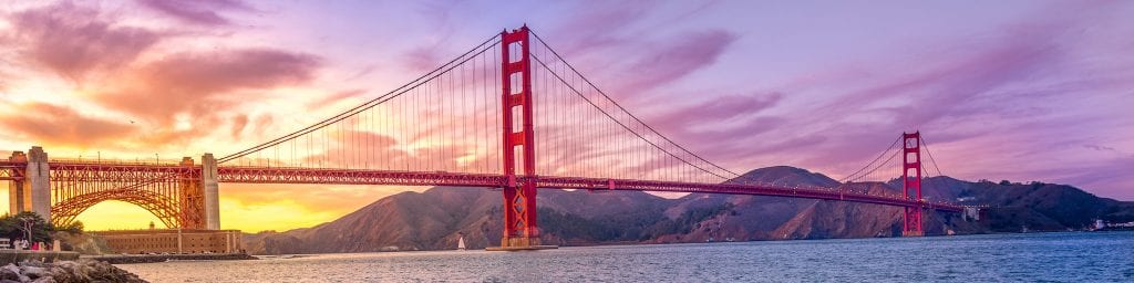
Most recently updated on January 4, 2024
Originally posted on May 18, 2021
We are homeward bound today and it’s a long drive through Northern California that includes forests, a latitude observatory, the last “company town” in the United States and a museum dedicated to one of the country’s most beloved comic strips.
So, we head out early from Brookings, Oregon, on southbound Highway 101 and within minutes we have crossed the border back into California, the 7th and final state that we visit more than once.

Just 13 miles after driving over the state line, we come across Pelican Bay State Prison, a facility that has been portrayed in movies as well as reported in the national media.
Pelican Bay was California’s first “supermax” prison. It sits on 275 acres and houses “the most serious criminal offenders” in the state. About 40 percent of the 3,000 Pelican Bay inmates are serving life sentences.
Half of the prison is general population while the other half is in more restrictive facilities. Most of the inmates in the Security Housing Units (SHU) have committed crimes at other prisons. This cell block house inmates in solitary confinement for up to 22 hours a day. Each of the inmates has an 7-foot by 11-foot concrete cell with no windows. There is also a 400-bed minimum security unit outside the main perimeter.
Pelican Bay State Prison opened in 1989 to accommodate a growing number of maximum security inmates.
Prisoners and their advocates have said the SHU complex is cruel and unusual punishment. They say the isolated inmates have PTSD-like symptoms that include hallucinations, depression and anger. There have been numerous hunger strikes, including a 2002 protest in which 60 SHU inmates participated. In 2011, a series of hunger strikes were staged by SHU inmates with prisoners from throughout the state joining in.
Oprah Winfrey did a “60 Minutes” report at Pelican Bay in 2018 in which she examined the conditions and spoke to prison officials and inmates.
Some of the famous prisoners who served time at the SHU have included Charles Manson.
The prison has been mentioned in numerous films and television shows, including by Denzel Washington’s character in “Training Day” who tells people they’re going to be “playing basketball in Pelican Bay.”
——————————–
A few miles south of the prison is the community of Crescent City, a town of 6,700 whose population includes the Pelican Bay inmates. The ethnicity here is listed as 50 percent white, 31 percent Hispanic or Latino, 7 percent Black and 6 percent American Indian or Alaskan native. The median annual household income is about $40,000, less than half the state average of $91,000. This area is one of the wettest places in California, getting about 70 inches of rain a year.
Crescent City is known for its fishing but also for its vulnerability to tsunamis.
Native tribes, including the Yurok and Tolowa, lived in the region as they fished and gathered berries and acorns.
The first European to visit the region was Jedidiah Smith who walked in by foot in the 1820s. White settlers, trappers and gold miners began moving in during the 1850s.

Crescent City is one of the wettest places in California, getting an average of 70 inches of rain per year. Photo by Traveller.com.au
The town grew because it was a good place for a harbor. Gold was discovered in the area in 1853 and the first lumber mill was built the same year. Agriculture expanded over the ensuing years, in particular dairies that sold much-in-demand butter.
In 1855, Congress authorized the construction of the Battery Point Lighthouse. It was initially lit in December 1856. The lighthouse still operates and is listed on the National Register of Historic Places.
The Douglas Memorial Bridge was completed in 1926 and the last lumber mill closed in 1939.
Rich fishing waters off the city’s crescent-shaped port makes fishing one of the prime drivers of the local economy today. Other prominent industries include tourism and timber.
Crescent City’s underwater geography makes it vulnerable to tsunamis. There have been 41 measured tsunami events since 1933. Four have caused serious damage.
One that hit in 1964 after an 9.2 earthquake in Alaska destroyed much of the town when a fourth wave that crested at 21 feet drew the harbor dry and then struck. Authorities counted 11 people dead and more than 100 people injured. A total 29 blocks were wiped out. In all, 289 buildings were destroyed, 1,000 cars were damaged and 25 large fishing boats were crushed. It was the worst tsunami to ever hit the West Coast.
In the 1980s, a breakwater was constructed offshore to protect the city against future waves. A warning siren system has also been installed.
An 8-foot tsunami struck the city in 2011 after a major earthquake in Japan with 35 boats in the harbor being destroyed. No on-shore property damage was reported.
The city has been using its history of tsunamis as a marketing tool for tourism.
Among other things, you can do a walking tour of the 1964 devastation through a program known as “Comeback Town, USA” that include high water marks on buildings.
Forests and Fishing
Surrounding Crescent City on its north, south and east are dense forests with some of the tallest trees in the world.
The Redwood National and State Parks is a conglomeration of national and state preserves with ancient redwoods. The total acreage is 139,000 acres, entirely in Del Norte County, where Crescent City is located, and Humboldt County, where we are headed next.
The region includes the Del Norte Coast, Jedediah Smith and Prairie Creek Redwoods state parks along with Redwoods National Park. The four parks protect nearly half of the world’s old growth redwoods (about 40,000 acres). The trees are among the oldest and tallest trees on Earth. There are also Douglas fir and spruce trees in the parks.
Many of the redwoods live for 500 to 700 years. A few have been documented to be more than 1,000 years old, making them among the oldest organisms on the planet. The tallest trees are about 370 feet high. The largest redwood by volume in the park is the Lost Monarch located in the Jedediah Smith park with a mass of 42,500 cubic feet and a height of 321 feet.

Some of the giant redwood trees in the forests of Northern California. Photo by Public Domain Pictures.
In 1850, the old growth rainforests on the California coast consisted of 2 million acres. Native American tribes lived here for centuries. The lush region attracted lumber industries and gold miners and the tribes were forced off their lands by settlers. By 1853, nine saw mills were operating in the Eureka area.
After decades of clear-cut logging to supply demand in San Francisco and elsewhere, efforts began in the 1910s to preserve some of the land. The campaign was led by Save the Redwoods League, which was founded in 1918. The three state parks were established in the 1920s and 1930s. Logging had consumed 90 percent of the original redwoods by the 1960s. Redwood National Park established was in 1968. The state and national parks were combined in 1994.
A number of threatened species are preserved in the park. Among them are the brown pelican, Chinook salmon, northern spotted owl and Stellar’s sea lion. The parks also protect 37 miles of coastline.
These forests face a number of issues. A lack of money has prevented major improvements. Timber companies have re-planted with non-native species of trees. Climate change is a threat, so controlled burns are now used to help return the park to its native state.
A plan to save the “Grove of Titans” in Jedediah Smith park was hatched in late 2018. The grove of 2,000-year-old, 320-foot trees was discovered in 1998 by researchers. The park service tried to keep the grove’s location secret, but over the next two decades word spread and people began hiking into the grove to snap photos. Those visitors left trash and trampled vegetation.
A $3.5 million two-year plan called for an elevated walkway, replanting vegetation, rerouting trails and constructing a parking lot and bathrooms one mile away. Construction on a 1,300-foot walkway began in November 2019 and was completed in September 2021. Save the Redwoods League and their partners successfully raised the money needed for this project with more than 3,000 league members donating and a matching grant from league supporter Josie Merck.
The Grove of Titans project is part of an initiative by Forever Forest and the league to raise $120 million for the next century of redwoods preservation. In April 2022, the organization announced it had exceeded its goal and raised $139 million from 50,000 different donors.
There have also been concerns about the number of trees dying in California’s state parks. In February 2019, state officials reported that more than 18 million trees had died in 2018, mostly from dehydration and beetle infestation. In March 2022, they said that more than 9 million trees had died in 2021. In February 2023, officials reported that 36 million trees had died in California in 2022.
The state launched a program in 2020 to clear brush as well as use strategic logging and prescribed fires to thin out 1 million acres of forests by 2025.
There is plenty to see and do in these parks. They have five visitors centers and receive more than 400,000 visitors in a typical year.
—————————————-
A little southwest of these forests is the town of Eureka, a community of 26,000 that is an important locale in what’s known as the North Coast region of California.
Eureka is the most populous coastal town between San Francisco and Portland, Oregon. It’s also the westernmost town with more than 25,000 people in the contiguous United States. In addition, the community is the regional center for government, arts, trade and healthcare for the North Coast region.
The Greater Eureka port is the largest deep water port between San Francisco and Coos Bay and is one of California’s major fishing ports. In fact, the entire city is a state historic landmark.
Native tribes, including the Yurok and Wiyot, lived in the region for thousands of years. The Wiyot tribe was driven off its land in the 1850s and then massacred in an 1860 attack in which at least 60 were killed.
Early explorers had trouble pinpointing the location of Humboldt Bay and the Eureka area because of the geography of the coast. An overland expedition finally nailed it in 1849. The town was founded in 1850.
The city served as a water-based alternative to the overland route between Sacramento and the Trinity, Klamath and Salmon rivers to supply miners. Eureka’s large harbor and proximity to the redwoods forests also drove its growth.

The Carson Mansion in Eureka, California, was reportedly the inspiration for the clock tower at the train station at Disneyland’s entrance. Photo by Shutterbug.
Fishing has always been a big industry here. Salmon fisheries sprang up on the Eel River as early as 1851. By 1858, 2,000 barrels of cured fish and 50,000 pounds of smoked salmon were processed and distributed from Eureka wharfs per year. In 1858, the first of a number of ships built in Eureka were launched, spurring an industry that lasted for decades.
Timber has also been a big industry. In 1856, the city had seven saw mills and was producing 2 million board feet of lumber per month. In 1914 the Northwestern Pacific Railroad was completed, giving timber companies an alternative to shipping.
A rise in immigrants from China presented problems in the late 1800s. In February 1885, a Eureka city councilman was killed when he was caught in the cross-fire between rival Chinese gangs. That night 600 angry citizens met and the next day they went door to door ordering all 310 Chinese residents to leave by 3 p.m. Chinese stores were also raided. The expulsion was known as the Eureka Plan. This rancor was being felt among white citizens across the country at that time. It led to the passage of the Chinese Exclusion Act in 1882, fueled by discrimination against Chinese immigrants who had arrived to work on the railroads. The act was repealed in 1943. We discuss this issue more in a special report on immigration on the 60 Days USA website.
The local economy today relies on tourism, timber, dairy, fishing and healthcare services. Humboldt Bay is home to the West Coast’s largest oyster farming operation. Products caught off Eureka include salmon, tuna, Dungeness crab and shrimp.
Some new economic opportunities may be in the air, too.
There are proposals for offshore wind energy farms along the North Coast. The big hurdle is transmitting the electricity to where the demand is located in the San Francisco Bay Area. Some in the fishing industry are concerned because wind farms can take away fishing grounds. Nonetheless, the Port of Humboldt Bay is looking into a potential redesign to accommodate any future offshore wind projects. In addition, the Redwood Coast Energy Authority has a pending lease application to build a floating turbine 25 miles off Eureka’s coast to generate 120 megawatts of wind power. If approved, it could be operational by 2024 and be California’s first offshore wind facility. In May 2022, the Biden administration announced it plans to sell 5 leases that encompass 370,000 acres with the potential to generate 4.5 gigawatts of offshore wind energy. Two of the leases would be near Humboldt Bay and the other 3 would in the Morro Bay region of Central California. In July 2022, Governor Gavin Newsom announced plans to expand the state’s offshore wind energy. In August 2022, the California Energy Commission announced goals of developing 2,000 to 5,000 megawatts of offshore wind power by 2030 and 25,000 megawatts by 2045.
Eureka is home to California’s oldest zoo, the Sequoia Park Zoo, which was established in 1907.
The city also has dozens of Victorian homes. One of them is the Carson Mansion, which was completed in 1885. It was once owned by lumber baron William Carson. He built it to keep 100 of his workers busy during a slump in the timber industry. It’s one of the more famous Queen Anne style homes in the country. The 3-story home has 18 rooms. It has served as the Ingomar Club since 1950 and isn’t open to the public.
The mansion is one of the country’s most photographed homes. It was reportedly the inspiration for the clock tower at the train station at the entrance to Disneyland. It’s also been the subject of a number of haunted house photos.
—————————————–
We continue to rumble southbound on Highway 101.
A half-hour after leaving Eureka, we arrive at the town of Scotia, a privately owned community of 470 people that officially is denoted as the last “company town” in the United States.
The town was founded in 1884 in an area known as Forestville by the Pacific Lumber Company to house workers for its lumber operations. The first saw mill began operations in 1887. The town was renamed Scotia in 1888 after its hard-working Nova Scotia immigrants.
In 1885, the lumber company built a railroad that connected the town to Humboldt Bay. By 1888, the mill with 300 workers was the nation’s largest producer of lumber at 20 million board feet a year. Much of the lumber was shipped out for home building elsewhere.
A second saw mill opened in 1910. At the time, it was the biggest redwood saw mill in the world. The town was linked to a yet larger rail network in 1914 by the completion of the Northwestern Pacific Railroad.

Scotia, California, is considered to have been the last “company town” in the United States. Photo by Wikipedia.
Scotia was one of a number of company towns across the country, many of which rose between 1830 and 1930 with the Industrial Revolution and loose government regulations. Pacific Lumber generally received good marks for how it provided for its workers and its community. It constructed inexpensive housing as well as stores, a hospital, a theater and a skating rink. The company was accused of anti-union practices, predatory land purchases and high mark-ups at its company store.
Many company towns closed during the Great Depression in the 1930s. Most of the existing homes in Scotia were built between 1910 and 1920. During World War One, Pacific Lumber hired Italian immigrants to work in the mill and women to work in its cigar box factory. World War Two brought another demand for lumber.
In 1986, Pacific Lumber built a 25-megawatt cogeneration power plant to provide electricity to businesses and homes. The facility now sells power to Pacific Gas & Electric Company.
Pacific Lumber Company’s business began to decrease in the second half of the 1900s as logging demand dropped and automation took over. Its employment declined from 1,000 to 300.
In 1998, David Chain, an Earth First! activist, was struck and killed by a falling tree while he protested on Pacific Lumber property. Company officials said loggers were unaware the protesters were nearby, but activists said a video tape showed the loggers yelling at the demonstrators before the fatal incident. In 2001, Pacific Lumber settled a wrongful death lawsuit with Chain’s mother and erected a memorial to her son.
In 1999, the company and other landowners sold 7,400 acres to create the Headwaters Forest Reserve. In 2003, the Humboldt County Planning Commission approved a rezoning of Scotia’s 225 acres into 213 acres of residential property and 12 acres of commercial land.
In 2008, Pacific Lumber went out of business as part of a reorganization plan under Chapter 11 bankruptcy. Its assets were taken over by the Humboldt Redwood Company, which still has a logging operation in town.
In summer 2018, protests were held at Humboldt Redwood’s offices to protest plans to cut down trees on 1,100 acres of pristine forest in the Rainbow Ridge area east of town. After some contested environmental hearings, logging began there in 2019.
Scotia is now officially a privately owned community under the name Town of Scotia Company LLC. The company is the overseer of the land in town except for Humboldt Redwood’s property. Scotia officials are in the process of selling all 270 homes to private owners, ending Scotia’s reign as the nation’s last company town. There is a Pacific Lumber historic marker in the downtown area.
————————————
We’re not quite done with the redwood trees for today.
Just 20 minutes south of Scotia is the famed Avenue of the Giants, a 31-mile scenic highway in Humboldt County that parallels Highway 101. The roadway travels through 51,000 acres of Humboldt Redwoods State Park and contains some of the tallest and oldest trees in the country.
The avenue’s northern entrance is in Pepperwood and the southern entrance is in Phillipsville. The two-lane road winds along the Eel River and connects with several small towns. It has a number of picnic areas, parking lots and attractions for visitors. Here’s some of them.

The Shrine Drive Thru Tree in the Avenue of the Giants forest in California is one of a number of tourist attractions here. Photo by Roadside America.
The Immortal Tree is a large redwood that’s more than 950 years old and 258 feet tall. It survived an attempt to cut it down in 1908 as well as a 1964 flood and a direct lightning strike that sheared off its top 40 feet. The tree has been family owned since 1967 and has a parking lot and gift shop.
Founders Grove near the town of Weott has a half-mile trail for hiking through old growth redwood forests. The grove includes the 324-foot Founder’s Tree, which fell in 1991 and rests where it landed. You can walk the length of it.
The Shrine Drive Thru Tree is located near the town of Myers. You can actually drive through a hole cut in the trunk. It’s been privately owned since 1958. The owner charges a fee to motor through.
The Eternal Tree House is a room that is partially built into a 2,500-year-old redwood tree with a gift shop, café and picnic tables. It is surrounded by a “fairy ring” of new trees
The Eel River itself is 800 miles long and has carved deep canyons as it cuts through the majestic forests. The river has three forks. The Avenue of the Giants follows its South Fork. The Eel has the third largest watershed in California. It’s said the trout is plentiful here.
The avenue used to be part of Highway 101, but a bypass was completed in 1960. The avenue was then designated as State Route 254.
Marijuana, Wine and Geysers
We edge out of the giant redwoods and in 10 minutes we’re in Garberville, where an entirely different kind of plant life is abundant.
The community of 1,400 residents along the Eel River once relied on timber and orchards for its economic livelihood, but now marijuana is king.
Native tribes, including the Sinkyone, lived in the region, although most of them were forced out by 1865.
The first European settlers arrived in 1853 and the town was laid out in 1862. The first post office opened in 1874. Postmaster Jacob C. Garber decided to name the settlement after himself.
The town was once home to large orchards of prune trees planted by Dutch immigrants.
Today, Garberville is part of what’s known as the Emerald Triangle.

The Emerald Triangle in Northern California is one of the prime marijuana cultivation spots in the country. Photo by The Morning News.
Marijuana cultivation has been big for the past 50 years in this region where Humboldt, Mendocino and Trinity counties merge. The crops were first planted in rural regions in the 1970s. Law enforcement cracked down in the 1980s, so growers learned how to cultivate plants indoors. Those that remained outdoors were sometimes guarded by armed growers who could get violent if someone trespassed onto their land.
Outdoor marijuana operations re-emerged after California passed its medical marijuana law in 1996. Then, recreational marijuana was approved in November 2016 and became legal in January 2018. It’s estimated 20,000 marijuana growers are located in the Emerald Triangle.
However, as much as 80 percent of marijuana business in California is still illicit. The state topped $5.7 billion in cannabis sales in 2021, but that number dipped to $5.3 billion in 2022. In addition, it’s estimated there are more than $8 billion in illegal sales per year. The motivation for the secret cultivation appears to be heavy regulation and taxes, which undercover growers can avoid.
In September 2021, the state allocated $1.5 million to the three countries that make up the Emerald Triangle to help local authorities clear out the “worst of the worst” illegal growers.
In January 2023, state lawmakers called for an investigation into California’s cannabis industry. They said there is rampant political corruption as well as abuse of farmworkers in the industry.
Marijuana cultivation has replaced timber as the number one industry in the Garberville area. The industry is known as the “Green Rush.” The area produces more marijuana than any other part of the country with an estimated $1 billion in crops per year.
October is known as “Croptober” when “trimmigrants” arrive to help harvest the cannabis crop.
———————————
We leave Garberville and motor along for more than an hour on southbound Highway 101 before we pull into Willits, a town with 5,000 residents that still has a counterculture feel to it.
The community is known as the gateway to the town of Mendocino, a quaint tourist village along the California coast that takes you an hour to reach from here along 40 miles of winding roads.

The sign in Willits, California, was donated to the city by officials in Reno, Nevada. Photo by Mendocino LAFCO.
Willits has an arched sign over its main street that was donated in 1995 by Reno, the Nevada town with the moniker of “Biggest Little City.” Willits employees tore off some of those panels, slapped on an American flag and inscribed the slogans “Gateway to the Redwoods” on one side and “Heart of Mendocino County” on the other.
The Pomo tribe originally inhabited this region for thousands of years. The first European settler was Hiram Willits, who arrived in the 1850s. Other settlers came soon after, working in ranching and the timber industry. A post office opened in 1861 and the city was incorporated in 1888 and named for Willits.
The tan bark industry was the early driver of the economy. In 1914, Willits was stationed as the halfway point between San Francisco and Eureka on the Northwestern Railroad. Highway 101 eventually replaced the railroad and Willits became a home to motels, cafes and gas stations.
In the 1970s, a “back to the land” movement brought urban hippies who opened tie dye and natural food stores to town. In the 1980s, Willits became the “solar energy capital of the world” as local entrepreneurs sold solar equipment to people who were growing marijuana “off the grid.”
Willits still has two operating lumber mills as well as thriving arts and music communities. It’s also near Ridgewood Ranch, where the famous race horse Seabiscuit trained and is now buried.
Willits was major player in a federal lawsuit that was filed against multiple corporate defendants that stated that hexavalent chromium from the Remco Hydraulics chrome plating plant that operated from 1964 to 1995 was responsible for a number of environmental pollution and health problems. Other defendants also filed lawsuits and the claims were consolidated into a federal complaint in 2008. About 300 of the 1,000 plaintiffs eventually reached a settlement while most of the rest were dismissed or denied.
Activist Erin Brockovich got involved in the legal action in 2002 because hexavalent chromium was the same chemical used by Pacific Gas & Electric Company in the small Southern California high desert town of Hinkley that we visited on Day 1 of our virtual journey.
The final claims in the Remco case were resolved in 2013. In 2018, the city dropped its legal actions to pave the way for final cleanup of the contaminated site.
——————————–
We rumble south on Highway 101 for another half-hour to reach our next destination.
Ukiah is a community of 16,000 people that rests along the Russian River. It was once known for hops and then pears, but it’s now part of the growing wine region in this section of California.
The Pomo tribe originally lived in the region before the area became part of Rancho Yokaya, a Spanish land grant region.

The Ukiah Latitude Observatory in California when it was operational. Photo by Atlas Obscura.
The first Anglo settler was John Parker, a vaquero who worked for pioneer cattleman John Black, who had driven a herd up the Russian River Valley and built a home for Parker to protect the cattle.
The town was founded in 1856 and Ukiah was incorporated in 1876. In 1889, the San Francisco and Northern Pacific Railroad terminus was located here.
Hops was the first major crop in Ukiah. It was first grown in 1868 and hit its peak production in 1885 before sales declined in the 1890s as prices dropped. The region still has 900 acres of hops in cultivation. Mendocino County is the third largest hops producer in the state.
The Ukiah area had also grown pears since 1840s. Alex R. Thomas and Company owned hundreds of acres of Bartlett pear trees. The company was in business for 90 years before shutting down its operations in 2009 after filing for bankruptcy. The site reopened in 2011 as a composting facility. Some pear orchards still operate around town.
Ukiah is now known for its wine industry. It has larger wine producing facilities such as Parducci Wine Cellars. However, 30 of the wineries in Ukiah Valley are 5 acres or less. The valley is about an hour and a half north of the better-known wine producing areas of Napa and Sonoma. The economy in Ukiah also features fruit packing, cattle and timber.
Finally, Ukiah has also played a historic role in earth sciences.
In 1899, Ukiah became one of six stations for the International Latitude Observatories. The others were in Cincinnati, Ohio, as well as Japan, Russia, China and Italy. These facilities all sat along the 39th parallel and measured the Earth’s rotational wobble by observing the stars. The observatories became obsolete in the 1980s with advancements in satellites and computer technology. The Ukiah Latitude Observatory is the only of these buildings that’s still standing. The facility closed in 1982, but the city maintained it as a scientific landmark. It was reopened as a historic park in 2014.
——————————————–
We don’t wobble and steer straight ahead on southbound Highway 101. After another 40 minutes we are in Geyserville, a town of less than 900 people that has an ethnic mix that is listed as 52 percent white and 43 percent Hispanic.
It is one of many examples of how expensive it is to live in California. The median annual household income is $115,000 and the average home price sits at more than $1.1 million.
As its name implies, Geyserville is built around the geology underneath its ground.

The Geysers geothermal field in Northern California. Photo by the USGS.
The geothermal fields were formed about 1 million years ago when molten magma protruded close to the Earth’s surface. Native Americans used this steam for centuries for cooking and heating.
The origins of the town began in 1847 when a series of hot springs and steam vents were found in a gorge in the mountains near Geyserville by a bear hunter named William Bell Elliott. Sightseers began arriving in 1851.
An area named The Geysers about an hour northeast of Geyserville became a tourist attraction and towns sprung up to accommodate the visitors. The Geysers Resort Hotel was built in 1854. A stagecoach line began running in 1836 and the San Francisco and Northern Pacific Railroad began stopping in Geyserville in the 1870s. By 1890, entrepreneurs were selling bottled water from the area.
The idea of producing electricity from The Geysers was first studied in 1922. Pacific Gas & Electric Company drilled the first commercial geothermal well in the United States in 1955. PG&E also opened the country’s first commercial geothermal power plant in 1960. Production peaked in 1987 when The Geysers was providing 1.8 million people with electricity. in 1989, there were 23 geothermal power plants with a capacity of 2,043 megawatts.
In the late 1980s, it was discovered that the steam extraction had begun to deplete The Geysers’ resources, so inefficient plants were shut down. The problem was solved by injecting 18 million gallons of treated wastewater per day from Santa Rosa and Lake County sewage treatment plants.
Today, The Geysers is the world’s largest complex of geothermal power plants. It’s also the world’s largest dry steam geothermal steam field.
The Geysers consists of 22 geothermal plants, 18 of which are currently operating, spread over 45 acres in Sonoma, Mendocino and Lake counties. The plants in current operation have a total of 900 megawatts of active installed capacity. The Geysers produces electricity for its three counties as well as Napa and Marin counties.
Calpine operates 13 of the power plants that produce 725 megawatts of power. The plants in Geyserville draw steam from more than 350 wells in the Mayacamas Mountains.
If you want to visit, a good place to start is the Calpine Geothermal Visitors Center, which has a new exhibit hall.
The economy in Geyserville does rely on visitors headed to The Geyserville, but it has other elements, too.
Agriculture has blossomed at times in the area with orchards, grain crops and cattle. Plums and pears were planted at one point and a “wine boom” began in the 1970s. There are now about a dozen wineries in the Geyserville area, including Francis Ford Coppola’s wine resort that has a swimming pool.
Comic Strips and Chickens
We keep barreling down the homestretch on southbound Highway 101.
A half-hour after leaving Geyserville, we enter Santa Rosa, a city of 175,000 residents that is 53 percent white and 34 percent Hispanic or Latino. It’s also the most populous community in this northern portion of the San Francisco Bay Area.
One of country’s best known cartoonists as well as one of the nation’s premiere botanists once called Santa Rosa home.

The Charles M. Schulz Museum and Research Center in Santa Rosa, California. Photo by the Schulz Museum.
A branch of the Pomo tribe lived in the region for 5,000 years. The tribe members were decimated by small pox and measles after the arrival of Europeans.
The city was founded in 1833 and named after Saint Rose of Lima. In the 1850s, a Wells Fargo post and a general store were established. The city was officially incorporated in 1868. It developed as a process shipping center for Sonoma County agriculture.
Most of the downtown was destroyed in the 1906 San Francisco earthquake. More than 100 people were killed. The city had slow but steady growth after that natural disaster.
The economy is no longer agriculture based. It relies on retail services for its large residential base.
In October 2017, about 6,700 homes and businesses in Santa Rosa were destroyed by the 7-day Tubbs Fire. That was 5 percent of the available housing stock. The city recovered once again. By February 2020, more than 2,000 homes here were in the rebuilding stages. In October 2020, city officials set aside $38 million in federal funds for affordable housing units.
The city has some connections to the entertainment and scientific worlds.
Alfred Hitchcock filmed “Shadow of a Doubt” in Santa Rosa in 1942. The Coen Brothers’ film “The Man Who Wasn’t There” takes place in circa 1949 Santa Rosa and Petaluma, although most of the film was shot in Los Angeles. Dozens of scenes from other films have been shot here.
Santa Rosa is home to the Charles M. Schulz Museum and Research Center. The cartoonist of “Peanuts” fame lived in Santa Rosa at the end of his life. He died here in 2000 at the age of 77. The museum was opened in 2002. It contains original “Peanuts” comic strips and other Schulz artwork. There’s also a 3.5 ton wood sculpture depicting the evolution of the dog Snoopy in the Great Hall. So is a 22-foot-high ceramic mural made of 3,588 “Peanuts” comic strips that depict Lucy Van Pelt holding the football for Charlie Brown to kick. A re-creation of Schulz’s personal studio is in the museum, too.

Part of the Luther Burbank Home and Gardens in Santa Rosa, California. Photo by the Burbank Home and Gardens.
The Redwood Empire Ice Arena, an outdoor ice rink that opened in 1969, was built and owned by Schulz. It’s commonly referred to as “Snoopy’s Home Ice.” The facility underwent a $1 million renovation in 2019.
Santa Rosa is also the locale for the Luther Burbank Home and Gardens. The botanist lived in Santa Rosa for nearly 50 years. The Massachusetts native was known for producing 800 new strains and varieties of fruits, vegetables, flowers and grasses. Among them were 113 types of plums. Burbank’s work led to the modern science of plant breeding.
After developing the Russet potato, Burbank established a nursery garden, a greenhouse and an experimental farm at his Santa Rosa property. He was influential in helping create the nation’s victory gardens during World War One, a topic we explored when we visited a victory garden in Minneapolis, Minnesota, on Day 47.
Burbank died in 1926. His widow, Elizabeth, lived in their home until 1977. The museum chronicles Burbank’s work while he was in Santa Rosa. The gardens are an ever-changing creation.
Finally, there’s The Church of One Tree, which was built in 1873 from a single 275-foot-tall redwood tree. Robert Ripley, a native of Santa Rosa, wrote about the church in one of his early “Believe It or Not” installments. In 1970, the church became the Ripley Memorial Museum. It served in that capacity until 1998, when it was closed. The facility was then renovated and reopened in 2011 as a city-run venue for weddings and other special events.
—————————–
Another 20 minutes on southbound Highway 101 brings us to Petaluma, a city of nearly 60,000 residents known for chickens, arm wrestling and ugly dogs.
The Coast Miwok lived in the region for centuries. The word “Petaluma” is from a tribal phrase meaning “hill backside.”
The town’s origins go back to 1836 with the construction of the Rancho Petaluma Abode under the orders of Gen. Mariano G. Vallejo, the commandant of the San Francisco Presidio. Vallejo’s compound was a 66,000-acre ranch that consisted of 10,000 cattle, 24,000 sheep, several herds of horses and 2,000 Native American workers.
Vallejo was forced to sell the ranch in 1857 after California became a state. The ranch ownership changed hands over the years and was finally purchased in 1951 by the state of California. The restored complex is now the Petaluma Adobe State Historic Park. It is the largest domestic adobe building remaining in the United States.
Petaluma began to grow after gold was discovered in Northern California in 1848 and Easterners moved westward. The town was founded in 1852 and incorporated in 1858. The Petaluma River locale amid rich farmland lured many settlers during the 1800s and early 1900s. Boats used the Petaluma River to transport goods to San Francisco and other areas. At one point it was third busiest inland port in California.
Petaluma was initially known for its grain milling industry with the Great Petaluma Mill being built in 1854. The facility has been renovated and is now a landmark building along the river with shops and restaurants.

The wrist wrestling statue in downtown Petaluma in Northern California. Photo by Roadside America.
The town soon became known for its chicken processing facilities. Petaluma was the place where the egg incubator was invented in 1879. The invention plus an ideal shipping location on the Petaluma River allowed the poultry industry to expand. The Chicken Pharmacy was opened in 1923 as the world’s first and only poultry pharmacy. By 1908, an estimated 75 percent of county residents raised poultry.
At that point, the city was known as the “Chicken Capital of the World,” “The Egg Capital of the World” and the “World’s Egg Basket.” A 1930s brick chicken processing plant still stands in the center of town, although it is no longer in use. Preservation efforts are under way.
The poultry industry declined in the 1960s with the last hatchery closing in 1989. The city holds a Butter & Eggs Day Parade and Festival in April.
The city still has a strong agricultural base with dairy farms, olive groves, vineyards, berry farms and vegetable farms, along with some remaining chicken industry. Lagunitas Brewing Company is also based here.
The first official airmail delivery took place here in 1911 when pilot Fred Wiseman flew a handful of mail from Petaluma to Santa Rosa. That plane is now in the National Air and Space Museum in Washington, D.C.
Petaluma is where the Polly Klaas Foundation was formed after the 12-year-old girl was kidnapped at knifepoint from her bedroom in 1993 and murdered by a career criminal. Polly’s father, Marc Klaas, started the nonprofit foundation, which is dedicated to the recovery of missing children and public policies to keep children safe in their communities.
Petaluma has a number of historic buildings and they have been used for a number of movies, including American Graffiti, Peggy Sue Got Married and Pleasantville. The city holds an American Graffiti Salute in May.
The city was the site of the World Wrist Wrestling Championships from 1953 to 2003. The competition was started by newspaper columnist Bill Sobranes, who observed arm wrestling bouts at a local saloon. The championships were moved to Reno, Nevada, after Sobranes death. The event was so famous at one point that in some of the “Peanuts” comic strips in 1968, Charles Schulz had Snoopy heading to Petaluma to compete. A wrist wrestling statue was installed downtown in 1988.
Finally, Petaluma is the locale every year of the World’s Ugliest Dog Contest. It’s part of the Sonoma-Marin County Fair that is usually staged in late June at the fairgrounds is in Petaluma. The contest has been held since the 1970s. The winner gets $1,500, a trophy and a free trip to New York. The fair has trademarked the name World’s Ugliest Dog. More than 2,000 people usually come to see the competition and it gets extensive media coverage. Dogs come from all over the country. Any breed can be entered and there are no categories by breed. The organizers of the event are strong advocates of animal rescue organizations.
Crossing That Final Bridge
We’re in the final stretch as we glide southbound on Highway 101.
A half-hour after Petaluma, we zoom by San Rafael, a community of 60,000 residents that’s just west of the infamous San Quentin State Prison. One of San Rafael’s claims to fame is its high school is apparently the origin of the April 20 date associated with marijuana smoking. In 1971, five students used to meet at 4:20 every afternoon by a statue on campus to smoke pot. They used the term “420” as a code to discuss their daily indulgence. Eventually, “420” became 4/20 and April 20.
Just 15 more minutes down 101 is the beautiful community of Sausalito, a city of 7,100 folks that sits on the northern shores of San Francisco Bay with a near perfect view of San Francisco itself. Sausalito is known for its colorful houseboats that reside in its harbor. One of those floating homes was reportedly the inspiration for Otis Redding when he wrote the song, “The Dock of the Bay” in summer 1967. The story goes that Redding was laying out on the boat “watching the tide roll away” when he penned the lyrics.

The Golden Gate Bridge connects San Francisco with Marin County and is considered one of the seven wonders of the modern world. Photo by Wikipedia.
Sausalito is the final town in this direction before you hit the magnificent Golden Gate Bridge, the famous Art Deco span that connects San Francisco to Marin County across the one-mile-wide strait where the Pacific Ocean comes into San Francisco Bay.
The bridge is listed as one of the seven wonders of the modern world by the American Society of Civil Engineers. Frommer’s travel guide says the Golden Gate Bridge is “possibly the most beautiful, certainly the most photographed, bridge in the world.”
The main span is 4,200 feet long and 90 feet wide with towers that are 746 feet high. The total length of the bridge is 1.7 miles from abutment to abutment.
The suspended roadway is supported by two 7,000-foot cables with 80,000 miles of wire each. The bridge has 1.2 million rivets. The roadway sits 220 feet above the water. A team of painters touch up the bridge constantly in its International Orange color, which was actually the hue of the original primer.
Before the bridge, ferry boats transported people from San Francisco to Marin County. The first ferries appeared in 1820s with scheduled services by 1840. The Sausalito Land and Ferry Company began service in 1868, eventually becoming the Golden Gate Ferry, which still operates today.
By 1900, many civic leaders felt the lack of a bridge to San Francisco was slowing the city’s growth. However, some were concerned the strong winds and dangerous tides across the strait would prevent construction.
A railroad bridge across the span was first proposed in 1872. Other plans were floated in the late 1800s. The first serious proposal was made in 1916, but it was deemed too expensive. James Strauss, an ambitious engineer, made a proposal in 1917 for a suspension bridge that gathered support. The military expressed concerns that the bridge would interfere with operations, but they received assurances it wouldn’t. The shipping industry opposed the plan as did those who thought it would ruin the gate’s natural beauty. Southern Pacific Railroad vehemently opposed the idea and filed a lawsuit, which they lost in 1932. Civic leaders and the automobile industry favored the span.
By 1923, almost 500,000 cars and trucks were using ferries to cross the Golden Gate. That year, the state Legislature approved the Golden Gate District and Highway Act of California to create a special district to plan and fund the bridge. A $35 million bond measure was approved in November 1930 at the beginning of the Great Depression. The bonds did not sell well until Bank of America purchased $6 million worth in 1932.
Construction began in 1933. A total of 11 construction workers were killed during the project, including 10 in one accident in February 1937. Another 19 workers were saved by safety nets strung beneath them.
The bridge was opened on May 27, 1937. About 200,000 pedestrians walked across the span on that first day. My mother-in-law, Jean McClure, was one of them. She was 15 at that time.
The bridge was the longest span in the world when it opened. The Golden Gate’s main span is now the 15th longest in the world. Its towers were the tallest in the world until 1993 when it was surpassed by the Mezcala Bridge in Mexico.
The bridge has six vehicle lanes and a movable barrier that shifts during the day, allowing four lanes southbound in the morning and four lanes northbound in the evening on most days. About 112,000 vehicles per day cross the bridge as well as 10,000 pedestrians and 6,000 bicyclists. The bridge gets more than 10 million visitors in a typical year.
The bridge is the most used site for suicides in the United States with an average of 30 per year. There have been more than 1,600 suicides since bridge opened. The fall from the bridge takes four seconds and the person hits the water at 75 miles per hour. About 5 percent of jumpers survive the fall, but most of them die from drowning or hypothermia. Construction of suicide nets along the bridge’s railing began in 2017 and the project was finished in early January 2024.
The bridge is subject to high winds. It’s been temporarily closed three times due to strong breezes. Those happened in December 1951 (69 mph gusts), in December 1982 (70 mph) and in December 1983 (75 mph).
In spring 2020, people who live relatively close the bridge complained that those high winds combined with foggy conditions creates a loud, humming noise that is annoying and disrupts sleep. The noise is apparently being caused by 12,000 new slats that were placed along the bridge’s sidewalk railing on its west side. In July 2021, a Los Angeles guitarist actually recorded duets using the bridge’s humming as a backing track. In December 2021, engineers announced they had come up with a $450,000 fix that involved placing U-shaped clips on all 12,000 slats. Noise complaints decreased in late 2022, but the loud humming resumed in January 2023 when a series of rainstorms swept through Northern California.
————————————-
The noise is no bother as we zoom across the bridge with Alcatraz Island to the east and the vastness of the Pacific Ocean to the west.
The golden span drops us down into San Francisco, the final stop on this 60-day journey.
The City by the Bay is the 18th most populous city in the country with 715,000 residents. It’s also the fourth most populous in California behind Los Angeles, San Diego and San Jose. The populace is listed as 38 percent white, 37 percent Asian and 16 percent Hispanic or Latino.
San Francisco is only 46 square miles, so it’s the second most densely populated major city in the country, behind only New York City. San Francisco is also a county, which is why it has a mayor as well as a board of supervisors.
The city is known for many things, including the Golden Gate Bridge, its iconic fog, cable cars, colorful Victorian homes and Alcatraz Island.
The Ohlone-speaking Yelamu tribe originally lived in the area.

San Francisco, California, known as the City by the Bay. Photo by Jooinn.
The city was founded in 1776 when colonists from Spain established the Presidio of San Francisco as well as Mission San Francisco de Asis. Both were named for St. Francis of Assisi. The first private dwelling was erected in 1835 by Capt. William Anthony Richardson, who put up a tent made of four redwood poles and a ship’s foresail at Yerba Buena Cove. The European population was only about 50 people in 1844. The United States laid claim to the city in 1846.
The Gold Rush of 1849 brought rapid growth to the city as 80,000 gold seekers came by land and sea. About 800 ships were docked here and then deserted by their crews. The city’s population grew from 1,000 to 25,000 during 1849.
The gold rush died down by 1857, but the discovery of silver in Nevada in 1859 brought another surge of newcomers. In 1870, San Francisco had a population of 150,000, making it the largest city on the West Coast at the time. Between 1870 and 1900, about 25 percent of California’s population resided in San Francisco. Immigrants came primarily from Italy along with Ireland, Germany and England as well as Jewish immigrants and immigrants from Asia.
The 1906 earthquake destroyed 28,000 buildings, killed as many as 3,000 people and left 250,000 homeless. The city quickly rebuilt and hosted the Panama-Pacific International Exposition in 1915.
During World War Two, San Francisco was a major embarkment post for military personnel shipping out. After the war, it was the birthplace of the United Nations.
In the 1950s, San Francisco was one of the leading cities of the “beat movement” for poets and comedians. In the 1960s, the counter culture took over San Francisco with the hippies and the Summer of Love in 1967. The rock music scene exploded with the Grateful Dead, Jefferson Airplane and countless other groups.
In the 1980s, the city was the center of the HIV crisis and San Francisco General Hospital was the place where many AIDS patients died. The city also led the way in HIV research.
San Francisco has been a pioneer in gay rights and LGBTQ rights.

One of San Francisco’s iconic cable cars. Photo by Patch.
It was home to the first lesbian rights organization in the country with the Daughters of Bilitis forming in 1955. The first gay pride parade in the nation was held here in 1970.
The city was the locale of the nation’s first openly gay elected official in 1977 with Harvey Milk being elected to the Board of Supervisors. The city also had the first openly lesbian judge (Mary C. Morgan) and the first transgender police commissioner in 2004 (Theresa Sparks).
The first same-sex marriage license was issued here in 2004. It’s estimated that 12 percent of San Francisco’s population is LGBTQ, the highest percentage among the 50 most populous cities in United States. It also has the highest percentage of same-sex households with nearly 3 percent.
Since World War Two, San Francisco has dealt with problems such as congestion, air pollution and water pollution. Many white families have moved to the suburbs, leaving the city with an older and more diverse population.
Homelessness has been a problem for decades. The latest official count shows about 7,700 homeless people in the city, a slight decrease from a few years ago.
San Francisco is the headquarters for Wells Fargo, Levi Strauss, Gap, Fitbit, Salesforce, Dropbox, Reddit, Airbnb, Pacific Gas & Electric Co., Yelp, Pinterest, Uber, Lyft, Mozilla and Craigslist. It is also home to the University of California San Francisco (UCSF), the University of San Francisco (USF), San Francisco State and Golden Gate University.
However, the COVID-19 pandemic has hit San Francisco’s economy hard. It reportedly has one of the worst recoveries in the nation from the two years of lockdowns and restrictions. Among the factors is the high number of people who work remotely among the city’s technology companies. In addition, homelessness and crime have convinced some offices and businesses to close up shop. Now, some business leaders have begun a campaign to “reimagine” the city’s downtown as a destination rather than an office hub. The city is also trying to rebuild its high tech industry by becoming a center for artificial intelligence companies.
There have been an uncountable number of television shows and movies shot in San Francisco. They include The Streets of San Francisco, Clint Eastwood’s Dirty Harry franchise, Mrs. Doubtfire, Nash Bridges and Bullit with Steve McQueen doing his own car chase scenes on city streets.
The majestic city of San Francisco seems like the proper end point for our 60 days of travel after 48 states, 33 state capitals, 370 towns and 400,000 words about the history, culture and flavor of our country.
It’s been quite a journey.