
Some Odd Quirks in our Geography
July 9, 2020
Some Interesting Facts About the States
June 22, 2020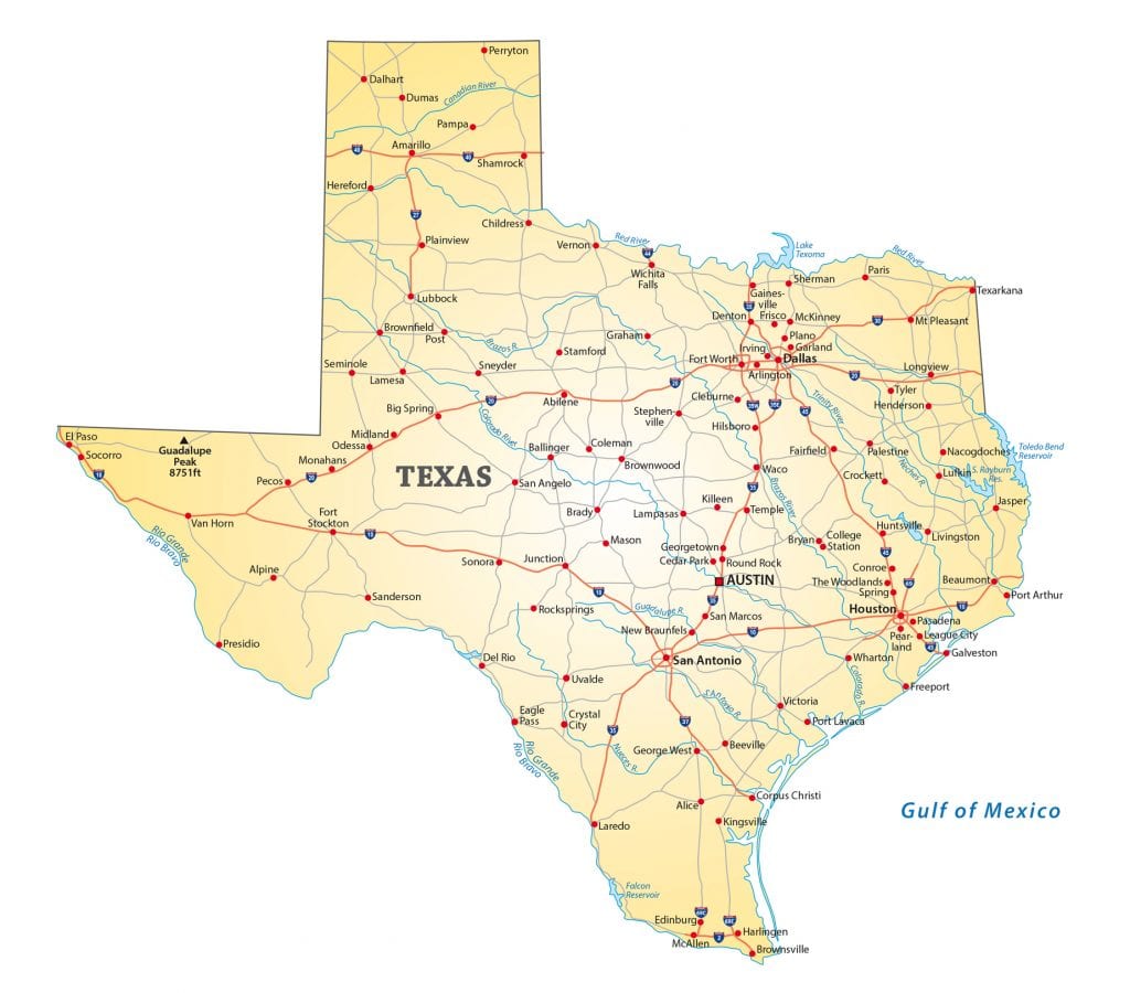
If you look at a map of the United States, you’ll see a variety of state borders.
Many are straight vertical and horizontal lines, especially in the western states. Most of those follow lines of latitude and longitude.
Other borders are squiggly, for lack of a better word. Most of these were created by rivers. The Mississippi River alone forms part of the boundaries for 10 states. The Ohio River is part of the boundaries of five states.
But then there are those appendages that stick out from the side of states.
They’re called panhandles because they tend to look like, well, the handle on a pan.
There are nine states that officially have these extensions.
Actually, there are 10 panhandles because one state has two of them. More on that later.
Let’s start our journey with the two states whose panhandles are most closely connected to the slavery issue.
Texas
Texas is the second largest state in total area, so its panhandle may not get a lot of attention.
However, this northerly extension of the Lone Star State is the largest panhandle of the nine located in the continental United States (that kind of gives away where the 10th one is).

The Texas panhandle is about 160 miles east to west at its widest and about 160 miles north to south. It’s 25,820 square miles, which is 10 percent of Texas’ total acreage. The region contains 26 counties and is larger than 10 states.
The formation of the panhandle started after Texas was admitted to the Union in 1845. It was pushed along following the conclusion of the Mexican-American War in 1848.
After that conflict, Texas leaders wanted their territory to include parts of New Mexico and other regions. Federal troops occupied those nearby lands and weren’t too keen on handing them over.
In addition, Texas wanted that entire territory to allow slavery. Anti-slavery forces weren’t thrilled with that idea either.
So, U.S. senators carved out the Compromise of 1850 that set Texas’ northern boundaries, and stay with me here, between the 100th meridian on the east and the 103rd meridian on the west going north to south as well as below the latitude 36 degrees 30 minutes going east to west to prevent slavery from encroaching northward of that line. That created the rectangle that now sticks up to the east of New Mexico.
Texas was paid $10 million for the land it gave up. The compromise also left a little territory between Texas and what soon would become Kansas.
And that brings us to Oklahoma.
Oklahoma
The Oklahoma panhandle had its beginning with the Missouri Compromise, the 1820 law that admitted Missouri as a slave state and Maine as a free state.
The compromise prohibited slavery in the remaining Louisiana Purchase lands north of the latitude of 36 degrees 30 minutes, the line that was used to draw the northern boundary of the Texas panhandle.

Things got more complicated after the Kansas-Nebraska Act of 1854, which set the guidelines for Kansas and Nebraska to eventually be admitted as states.
That law repealed the Missouri Compromise statute and set the northern boundary for slavery at the 37th parallel.
That created a gap 34 miles wide and 166 miles long between Texas’ northern panhandle boundary and the southern boundary of Kansas. The 5,600-square-mile region was designated a “No Man’s Land” and laid unclaimed by any state or territory for the next 40 years.
Historians report that the wasteland known by some as the Cimarron Territory was a violent, lawless region for most of that time. It became particularly boisterous when the temperance movement led by Carry Nation began closing saloons in Kansas. The bar owners and brothels quickly found a safe haven in No Man’s Land. One boom town was straightforwardly named Beer City.
The strip was finally assigned to the Oklahoma Territory in 1890 and stayed as part of Oklahoma when it became a state in 1907.
Today, Cimarron County in the tip of the panhandle is the least populated county in Oklahoma. It’s also the only county in the United States that borders five states (Oklahoma, Texas, Kansas, Colorado, and New Mexico).
And with that, we will head east to visit the most populous as well as probably the best known of the nation’s panhandles.
Florida
The Florida panhandle is about 200 miles long and 50 to 100 miles wide. That makes it about 11,000 square miles, double the size of the Oklahoma panhandle but about half the size of Texas’ appendage.
More than 1.4 million people live in the 16 counties in this strip of land, making it the most populated of the nation’s 10 panhandles. The biggest city is the state capital of Tallahassee with nearly 200,000 people. Pensacola, along the Gulf Coast at the Alabama border, is next with 52,000 residents. The area is also home to six military facilities as well as three seaports.

The origins of the Florida panhandle go back to the early 1700s. That’s when the French controlled this part of what is now Florida while Spain ruled over the rest of the territory.
The history of the region is complex and involves four countries and three U.S. presidents.
In the 1760s, the French relinquished their properties in America to the English as part of the treaty that ended the French and Indian War. England now had control of this strip of land while Spain still oversaw much of the territory around it.
The British then split the territory into West Florida and East Florida. They also ruled over most of what is now Alabama.
Then came the Revolutionary War, which Britain lost. They relinquished most of their territory to the newly formed United States of America. Spain took advantage of the situation and seized most of Florida.
In 1802, French leader Napoleon Bonaparte made a secret deal with Spain to gain control of the Louisiana Purchase territory. He promptly sold that land to President Thomas Jefferson and the United States in 1803.
The newly acquired property set up a dispute between the United States and Spain over West Florida.
The situation didn’t sit well with Jefferson as well as Presidents James Madison and James Monroe. They found it difficult for the United States to defend the important port of New Orleans with Spanish forts so close by. They sent troops to patrol part of the panhandle region beginning in 1810.
Alabama became a state in 1819 with its borders as they are today. Spain finally lost interest in Florida and handed it over to the United States in 1821.
The panhandle, known as West Florida, became part of Florida when that state was admitted to the union.
To this day, many officials in Alabama feel their state was cheated out of the panhandle.
Alabama officials petitioned Congress in 1819 and 1821 for the land but were denied each time. They tried again in 1845, 1848, 1858, and 1873, all to no avail. The last attempt to wrest away western Florida was in 1963.
Despite the defeats, many people in The Cotton State feel the panhandle is really lower Alabama. And many folks in the panhandle feel closer ties to Alabama than they do to Florida.
Among other things, the part of the panhandle west of Tallahassee is on Central Time, the same as Alabama, as opposed to the Eastern time zone in the rest of Florida.
You can also apparently see a lot of University of Alabama and Auburn University bumper stickers in towns throughout the panhandle.
There’s a similar disconnect in a state in the middle of the country where panhandle residents feel they are more part of the West than they are the Midwest.
Nebraska
A lot of people may not think of Nebraska as having a panhandle, but it most certainly does.
Look at a map and there it is. A rectangle a little longer than it is wide sticking out westward from the rest of the state surrounded by South Dakota, Wyoming, and Colorado.

Officially, the Nebraska panhandle is about 100 miles east to west and 120 miles north to south. It’s 11 counties consisting of 14,181 square miles, about 18 percent of Nebraska’s total land area.
Around 88,000 people live in this panhandle, about 5 percent of Nebraska’s total population. Its largest town is Scottsbluff, a community of 14,000 best known for growing sugar beets.
It’s not certain how this rectangular territory ended up as part of The Cornhusker State.
Some surmise it was what was left over after Colorado, South Dakota and Wyoming drew up their boundaries.
Others connect it to the Homestead Act, the 1862 law that provided settlers with 160 acres of property for a nominal filing fee if they stayed and worked the land for at least five years.
Still others say it was the railroads that came through or even the establishment of the Oregon Trail.
However it came to be, the Nebraska Panhandle is home to a slightly different breed of Nebraskan. Most are proud of their state, but apparently at least some of them consider themselves part of the western United States instead of the Midwest.
There have even been efforts in recent years to sell the region’s Old West flavor to boost tourism.
Ironically, there is a brick star at 13th and O streets in downtown Lincoln, Nebraska, proclaiming that the West begins at that spot.
Folks in Scottsbluff, Chadron, and other towns in the Nebraska Panhandle might think it starts about 300 miles farther west.
Next, we travel 900 miles to the northwest for a more famous panhandle that has an even more rugged western atmosphere.
Idaho
The Idaho panhandle is bigger than most people probably realize.
That’s because it begins farther south than you might think, officially launching where Idaho starts to broaden out. It’s more than just an index finger sticking up.

The panhandle is 45 miles wide at the Canadian border, but it’s closer to 200 miles across at its base. The strip of land is also 150 miles from north to south.
The territory includes 10 counties and 21,012 square miles, making it the third largest of the country’s 10 panhandles. More than 300,000 people live there, about 20 percent of the state’s population.
The panhandle was carved out of the Washington Territory, which in 1863 was a rectangular region that also contained part of Montana. The Idaho Territory, which was formed that same year, was a rectangle that lay to the south and also included some of Montana as well as most of Wyoming.
The first piece to fall aside was what is now the state of Washington. Political forces wanted Olympia to be the territory’s center and its capital, so they weren’t interested in the eastern section that includes what today is the Idaho Panhandle and a sliver of western Montana. They convinced Congress to give them the new boundaries they wanted.
In 1864, Montana withdrew from the territory and succeeded in getting its western boundary placed along the Bitterroot Mountains instead of the Continental Divide in the Rocky Mountains more than 100 miles farther east. That’s where Idaho officials wanted the state border to be.
That left the “finger” of land sticking up between Montana and Washington that was eventually included as part of the state of Idaho.
This area, which is also known as Northern Idaho, is more wilderness than the rest of the Gem State. In fact, if you want to drive from the upper half of the panhandle to the southern part of Idaho, you pretty much have to go through either Washington or Montana due to the mountain ranges.
The panhandle also separates itself by observing Pacific Time instead of the Mountain Time to which the rest of the state sets their clocks.
If you ask people in the northern towns such as Coeur d’Alene, many will tell you they identify more with the nearby city of Spokane, Washington than they do with Idaho.
We’re close to Canada at this juncture, so let’s continue our journey even farther north to visit the nation’s largest panhandle.
Alaska
You might not think of Alaska as having a panhandle, but if you look closely at a map it’s there and it’s definitely a panhandle.
This strip of land connects to the main part of our 49th state through a thin slice of land at the southwest corner of Canada’s Yukon Territory. From there, it runs along the coast of British Columbia all the way down to Prince Rupert, which is less than 500 miles as the crow flies from the continental United States. The locals refer to their region simply as Southeast.

The Alaska panhandle is not an insignificant piece of property.
For starters, it’s 480 miles long and about 100 miles wide. Its 35,138 square miles makes it the largest of the nation’s 10 panhandles.
The state capital of Juneau is there. In addition, the region is the center of Alaska’s timber industry. It’s also still a major fishing area. The panhandle receives the most rain of any part of the state, topping 150 inches per year in some areas.
Two centuries ago, the panhandle was at the center of a colonial border dispute between Russia and Great Britain. The final outcome is something for which some Canadians still cannot quite forgive jolly old England.
In the late 1700s and early 1800s, Russian explorers, whalers, and traders settled along this coastline, claiming the land for the Russian empire. The plentiful supply of fish and sea otters was a main attraction.
British and American explorers began to visit the area in the decades that followed.
In 1825, the Russian and British governments signed a treaty that set the southern border approximately where it is today. However, it did not establish a firm eastern boundary.
In 1867, the United States purchased Alaska from the Russians, a deal initially ridiculed as “Seward’s Folly.” The agreement included the panhandle.
After British Columbia joined Canada in 1871, officials there asked the United States to survey the panhandle to establish an eastern border. U.S. officials weren’t interested.
In 1897, the Klondike Gold Rush exploded onto the scene. This brought the panhandle dispute to the forefront because Canadian officials wanted a direct route from the gold fields to the Pacific coast.
The disagreement was eventually handed over to an international tribunal in 1903. The panel members agreed on the southern boundary and that the eastern border should be 56 kilometers east of the coast. However, there was disagreement over where exactly the coastline began.
The argument ended when the British representative on the panel sided with the United States. Officials in Canada were outraged and refused to sign the tribunal’s findings. It didn’t matter. The panel’s decision was final and the boundaries were set. A strong anti-British backlash swept through Canada. Historians say these feelings led to Canada seeking more independence from Great Britain after World War One.
From the Pacific Coast, we will now soar across the country to the Atlantic Coast, where we find the smallest and oldest of the nation’s panhandles.
Connecticut
Connecticut has a panhandle?
Why yes, it does.
But you can be excused if you’ve never noticed it.

The Connecticut panhandle is all of 48 square miles. The rectangular piece of land sits in Connecticut’s southwestern corner. It’s surrounded by the southeastern corner of New York and is across the waters from Long Island.
It encompasses Fairfield County and high-income towns such as Greenwich.
The panhandle’s history dates back to 1650 when Dutch and English colonial leaders established the western boundary of the Connecticut colony. The line extended northward from Greenwich Bay under the agreement that the boundary not come within 10 miles of the Hudson River.
A charter signed in 1662 more firmly set Connecticut’s borders, but a 1664 patent gave the Duke of York possession of “all land from the west side of the Connecticut River to the east side of Delaware Bay.”
Disputes continued over the acreage for the next two decades. At one point, the governor of New York issued arrest warrants for residents of border towns who pledged allegiance to Connecticut. Some New Yorkers also set up a settlement in Tarrytown, an area Connecticut considered part of their territory.
In 1683, New York and Connecticut finally settled their dispute with Connecticut receiving the 61,000-acre rectangle now known as the panhandle. It was the first of the nation’s 10 panhandles to be shown on a map.
The box of land provided Connecticut with better access to New York harbors. In exchange, New York received the town of Rye as well as a strip of territory 1.8 miles wide that runs the entire length of Connecticut’s western border. That “oblong,” as it’s known, was about the same acreage as Connecticut’s panhandle.
Some of the locals refer to their part of the state as the “Connecticut tail.”
With that, let’s high tail it a little south and a little west for a panhandle that’s connected to the rest of its state by a 1-mile-wide strip of land.
Maryland
Maryland is a funny looking state if you really study it.
It’s got a scraggly border along both sides of the northern waters of Chesapeake Bay. The state capital of Annapolis is on the western banks. So is the metropolis of Baltimore.

As you travel north and west past Frederick and Hagerstown, the state of Maryland begins to funnel, all the way to where West Virginia and Pennsylvania seem to meet. Except they don’t.
There’s a one-mile neck of land that wedges itself in between those two states. It’s referred to as “Maryland’s waist” because it looks like the midsection of one of those 19th-century women who wore a corset. The town of Hancock is there, a half-mile from Pennsylvania and a half-mile from West Virginia.
More importantly, the “waist” connects the main part of Maryland with a panhandle that stretches west another 80 miles and dips south another 50 miles. A total of 1,840 square miles.
Its boundaries include the Potomac River on the south and the Mason-Dixon Line on the north.
The Maryland panhandle was created in 1781 after Maryland and other smaller states convinced the Continental Congress to let them keep some of their western lands to provide access to farmland and the Mississippi River system. The deal required Pennsylvania to give up its claim to western Maryland. The settlers in Maryland felt so strongly about the territory that they refused to sign the Articles of Confederation until they were given the land. That’s why they were the 13th and final of the original colonies to approve the articles that formally named this new country “The United States of America” and eventually set up the U.S. government. The other states had approved the articles by 1779, in the midst of the Revolutionary War. Maryland held out for two years until it got what it wanted.
The panhandle is more mountainous and more agricultural than the rest of Maryland. In fact, it contains the state’s only ski resort and is actually considered part of Appalachia, a far cry from the coastal cities of Baltimore and Annapolis.
The folks who live in the panhandle also are quite different than the residents of the rest of the state. My daughter, Melinda, was chief of staff for a Maryland state senator when she was fresh out of college. She said the phone calls they got from western Maryland were quite different than the ones from constituents in the eastern half of the state. They were more concerned about gun rights, taxes and other conservative causes than the urban issues that were on the front burner elsewhere.
In 2014, the panhandle citizens actually started a petition drive to break away and form the new state of Western Maryland. That campaign did not succeed.
This region of Maryland is actually bordered on the south and east by another panhandle. The only other place where two panhandles meet is the Texas-Oklahoma state line.
And this particular panhandle is just one of two that this state has.
West Virginia
Most people probably don’t realize West Virginia has a panhandle, much less two of them.
Both have interesting histories.
Let’s start with the eastern panhandle, the one that is sandwiched between Virginia and Maryland. This chunk of land sticks out in a northeasterly direction from the main section of West Virginia. It narrows to a 50-mile neck before branching out again.

It’s about 3,500 square miles, consisting of eight counties with 260,000 residents. It’s more closely tied to Washington, D.C., than the rest of the state.
This panhandle used to be part of the large state of Virginia, but it was included in West Virginia’s borders when that region broke away from Virginia after that state seceded from the Union at the start of the Civil War.
West Virginia snatched the panhandle because it contained the strategic armory at Harpers Ferry, the site of abolitionist John Brown’s raid in 1859. The area also contained Baltimore & Ohio Railroad tracks that were important to Union soldiers.
The eastern Panhandle has been part of West Virginia ever since, although in 2011 a state official proposed that the land rejoin Virginia due to the economic policies of West Virginia. That proposal did not gain much traction.
The northern panhandle of West Virginia is basically a rod-shaped territory that sticks up between Ohio and Pennsylvania. You have to look closely at a map to see it.
This panhandle is 64 miles north to south and narrows to as little as 4 miles wide in some areas. In total, it’s 585 square miles with 130,000 residents in four counties.
It was created as part of Virginia after the Revolutionary War when Virginia’s northern boundary was set along the Ohio River as an agreement to settle colonial land disputes between Virginia and Pennsylvania.
The northern panhandle became part of West Virginia when the region broke away from Virginia at the start of the Civil War. In fact, the two conventions that were held during this time to vote on forming the state of West Virginia were situated in the town of Wheeling in the northern panhandle.
The panhandle became an industrial center of iron and steel in the late 1800s due to its prime location along the Ohio River.
There are some oddities with this finger of land. The Census Bureau officially counts the northern panhandle as part of the South even though most of this parcel of land is farther north than Philadelphia and its tip is almost as far north as New York City. The panhandle’s northernmost community of Chester is only an hour and a half from Lake Erie. In fact, the panhandle’s two most northern counties are generally considered to be part of the nearby Pittsburgh metropolitan area.
What about….?
There are two states that have protrusions that look like panhandles but aren’t labeled as such.
Utah has that notch that includes Salt Lake City and the territory north of that capital city.
New York has a somewhat funnel-shaped tail that includes New York City.
According to the World Atlas, those two extensions aren’t considered panhandles because they contain the most densely populated regions of those states.
