
Day 34: From Laughter to Remembrance
April 22, 2021
Day 32: A ‘Wonderful’ Drive Through Upstate New York
April 20, 2021Most recently updated on February 3, 2024
Originally posted on April 21, 2021
Have you ever tried a “garbage plate” or a beef on weck sandwich?
We’ll take a look at both of these menu items as we cruise through the northwest corner of New York on today’s journey.
Along the way, we’ll visit museums for toys, photography and women’s rights.
We’ll also take a deep dive into a neighborhood that made national news more than 40 years ago because of how polluted its soil and water had become.
And we’ll stop by one of the country’s most popular tourist attractions.
We head out of Seneca Falls by traveling northbound on Highway 101 and Highway 318 until we reach Interstate 90, the longest freeway in the United States. We’ll have more on this cross-country, east-west roadway later in the trip.
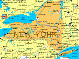
Today, we travel west on I-90 for a half-hour until we exit onto Interstate 490 north. In 20 minutes, we have reached Rochester, a community of 205,000 people on the shores of Lake Ontario. Rochester is the third most populous city in New York with a population that is 38 percent Black, 36 percent white and 19 percent Hispanic or Latino.
It’s considered America’s first “boom town” as well as the birthplace of some of our nation’s most famous companies.
The Seneca tribe lived in this area until they handed over nearly 4 million acres of their land in exchange for $100,000 in the Treaty of Big Tree in 1797.
In 1802, three Maryland entrepreneurs, including Colonel Nathaniel Rochester, purchased 100 acres from Ebenezer Allan, who had built a saw mill and grist mill at Genesee River High Falls in 1789. The entrepreneurs saw the water power potential along the river. They laid out the town’s streets in 1811. A village was formed in 1817 and the city was incorporated in 1834.
Rochester initially “boomed” due to the fertile soil of the Genesee River Valley as well as the completion of the Erie Canal and the arrival of the railroads.
Flour mills sprung up from wheat grown in the valley. Rochester was the country’s leading flour producing town in 1838 and was known as Flour City. Its population doubled in 10 years.
The flour industry declined as the nation’s wheat production center slid to the Midwest, so Rochester became a manufacturing hub. It also became a nursery-oriented city with flower growing operations ringing the city, earning it the new same-sounding nickname of The Flower City.
In the early 1900s, the city became a center for the garment industry, in particular men’s clothing. There was also Cunningham and Son, which made carriages and then automobiles.
Rochester was also the birthplace of a number of well-known companies.
Kodak started here as did Western Union, Xerox and Bausch & Lomb. French’s Mustard used to be located at 1 Mustard Street and employed 1,000 people. Ragu spaghetti sauce began in a kitchen in a Rochester home during the Great Depression, eventually growing into a manufacturing plant with 300 workers.
The city reached its zenith in population in 1950 when it had 330,000 residents. It’s lost a third of that populace in the past 70 years as industries have closed or moved elsewhere. Some high-tech companies are starting to move in, buoyed by the presence of the University of Rochester and the Rochester Institute of Technology, both renowned research facilities. In May 2023, construction began on a project to build 24 single-family homes on vacant city-owned parcels. The “Buy the Block” program is designed to help people in communities of color to own their own homes.
Part of Rochester’s industrial past is captured at the George Eastman Museum, which showcases the history of the camera as well as photography.
George Eastman founded Kodak here in the 1880s. He was born in 1854 in Waterville, New York, the same year his father established Eastman’s Commercial College in Rochester. His family moved to Rochester in 1860, but his father died two years later. Eastman started working at age 14 to support his family.
When he was 23, Eastman bought his first camera. He became obsessed with photography and the photographic development process. He experimented with easier ways to develop film in his mother’s kitchen. In 1880, he had patented a dry-coat plate coating machine.
In 1881, the young inventor established the Eastman Dry Plate Company. In 1892, he formed the Eastman Kodak Company in Rochester. Over the decades, the company created easy-to-use cameras that made photography more accessible to the general public. In addition, Kodak engineers established the practice of professional photofinishing as well as a flexible film that was vital to the early motion picture industry.
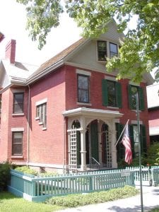
The National Susan B. Anthony Museum & House in Rochester, New York. Photo by the National Park Service.
Eastman was also a philanthropist who donated $100 million during his lifetime to universities, hospitals, art institutes and other places.
The museum is located in Eastman’s colonial-style, 50-room home that was built in 1905. It’s the oldest photography museum in the world. The exhibits include a gallery of Civil War photos. The facility also has the 500-seat Dryden Theater.
The National Susan B. Anthony Museum & House remembers another famous Rochester resident.
Susan B. Anthony lived in her Rochester home the final 40 years of her life. She was born in 1820 in Massachusetts. Her father was raised as a Quaker. Anthony and her seven siblings were guided through life by the principle that everyone was created equal under God.
Inspired by that belief, Anthony became active in the anti-slavery movement in the 1850s. She delivered speeches on that topic, even though at the time it was generally thought that women shouldn’t make public pronouncements.
Anthony’s activism eventually spread to women’s rights. That desire was heightened when the 14th and 15th Amendments were approved in the 1860s, giving voting rights to Black citizens but not to women. Along with Elizabeth Cady Stanton, Anthony formed the American Equal Rights Association as well as the National Woman Suffrage Association.
Anthony was actually arrested in the living room of her Rochester home for voting in the 1872 presidential election. Her arrest and the $100 fine that accompanied it drew national attention to the suffrage movement. On the nation’s 100th anniversary in 1876, she delivered a “Declaration of Rights” speech. Anthony died in 1906, 14 years before the 19th Amendment gave women the right to vote.
Anthony’s house was purchased as a memorial in 1945. It was declared a National Historic Landmark in 1965. There is a celebration here every August to commemorate the 1920 passage of the 19th Amendment.
Anthony is buried at nearby Mount Hope Cemetery. Every election, women place “I Voted” stickers at her grave.
Another famous activist who is honored in Rochester is Frederick Douglass, the well-known leader of the nation’s anti-slavery movement.
Douglass was born into slavery around 1818 in Mississippi. He was raised on a plantation in the Baltimore area and learned to read and write from the plantation owner’s wife as well as white children. He read newspapers constantly and developed his strong opposition to slavery.
Douglass tried to escape from slavery three times before succeeding on his final attempt in 1838. He made his way to a safe house. Douglass began making public speeches against slavery as well as founding several abolitionist publications. He even spent two years in England and Ireland from 1845 to 1847 speaking about the evils of slavery.
Douglass lived in Rochester for 25 years, beginning in 1847. He founded his abolitionist newspaper, The North Star, while he was here. At one point, the publication had 4,000 readers.
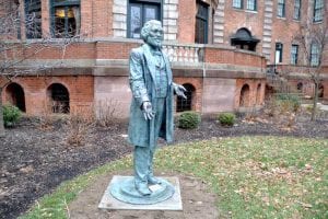
One of the many statues of Frederick Douglass in Rochester, New York. Photo by Orleans Hub.
Douglass became friends with Anthony while they both lived in town. Douglass was also a champion of women’s rights, speaking at the Seneca Falls Convention in 1848. He was one of the most famous Black men in the country and advised both President Abraham Lincoln and President Andrew Johnson.
A statue of Douglass stands in the city’s Highland Park. The memorial, first dedicated in 1899 at the local train station before being moved to the park in 1941, was the first statue in the United States to honor an African-American man. There are 13 other statues of Douglass in town, all smaller replicas of the Highland Park statue.
History of another kind is remembered at The Strong National Museum of Play. The museum’s mission is to explore and encourage play in ways that encourages learning, creativity and discovery. It does so through public programs, research projects, publications and exhibitions. The museum was founded in 1968 by Margaret Woodbury Strong. It opened in its current, 13-acre, 156,000-square-foot facility in 1982.
Inside the museum is the National Toy Hall of Fame. This exhibit recognizes toys that have inspired creativity and have had sustained popularity. In other words, no fads. So far, more than 80 toys have been inducted into the hall. They range from alphabet blocks to Barbie dolls to the Candy Land game to coloring books to the Slinky to the wiffle ball to even the plain old wooden stick. The 2023 inductees included baseball cards, Nerf toys and Cabbage Patch Kids dolls.
Finally, the city is known for its “white hot,” a variation of hot dog made with a Zweigle’s “white hot,” Rochester meat sauce, mustard and onions.
There’s also the “Garbage Plate” dished up at Nick Tahou Hots, which has been serving customers since 1918. The specialty comes complete with a hot dog, hamburger, Italian sausage, chicken or steak with a hot sauce topping served on top of any combination of macaroni salad, home fries, French fries and baked beans. Although the name is trademarked by Tahou Hots, you can find variations of the recipes at other restaurants.
A Romantic Spot and a Not-So-Lovely Neighborhood
We’ll leave Rochester on a full stomach.
As we depart, we’ll tip our hat to Lake Ontario, which has long been a vital part of the city’s economy.
Ontario is the easternmost of the five Great Lakes and its smallest in surface area. However, in volume it is bigger than Lake Erie.
The shoreline of Ontario, including islands, is 712 miles. Its deepest point is 802 feet and its average depth is 283 feet, the second deepest behind only Lake Superior.
The deepness of the lake makes the waters run a little slower. It actually takes six years for water than enters the lake from Niagara Falls to exit the lake on its way to the St. Lawrence River.
The lake has a number of ports as well as the cities of Rochester and Toronto along its shores. It provides drinking water to 9 million people in both Canada and the United States.
Ontario supports numerous industries. Since it’s the easternmost, it also has the lowest elevation at 243 feet as water from the other four lakes pours toward it.
Those factors also make Ontario the most polluted of the Great Lakes. Among the effects of that pollution are poor water quality, a loss of biodiversity and the onset of invasive species. It has also prompted some restrictions on the consumption of fish from the lake. In June 2022, students at the University of Toronto reported they’ve been pulling 10,000 pieces of microplastics per day from 10 small bins they’ve placed around the lake.
The Environmental Protection Agency and other organizations have drawn up plans to help protect the lake. In July 2021, the state of New York allocated $14 million for shoreline protection upgrades. The National Oceanic and Atmospheric Administration has also proposed an underwater national marine sanctuary for the eastern portion of the lake and the St. Lawrence River. In April 2022, the organization Nature Canada unveiled preliminary plans to establish a large portion of the lake as a marine conservation area.
We see a lot of Lake Ontario after we meander on various highways north out of Rochester and head westbound on Highway 18, also known as the Lake Ontario State Parkway.
We pass through shoreline towns such as Olcutt and Hopkins Beach. We spend nearly an hour buzzing along Ontario’s coast before we turn south on the Niagara Scenic Parkway.
Along the 15-mile roadway, we view the Niagara River flowing in the opposite direction as it travels from Lake Erie to Lake Ontario.
A few minutes later, we arrive at Niagara Falls State Park.
This 400-acre preserve is the oldest state park in the United States, having been established in 1885.
The waterfalls were formed when glaciers receded and the Great Lakes started draining through a gorge toward the Atlantic Ocean. More than 12,000 years ago, the waterfalls were seven miles downriver from where they are today.
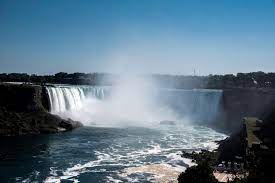
The beauty of Niagara Falls in upstate New York. Photo by GoodFreePhotos.
The edge of the falls used to erode as much as 6 feet per year, but U.S. and Canadian officials now control the flow and divert water for hydroelectric power. The erosion is now 1 foot per year.
Hydroelectric power was first harnessed here in 1759 to run a saw mill. The first hydroelectric station was constructed in 1881. That facility illuminated the falls at night and powered all the street lamps in the city of Niagara Falls. The first large hydroelectric power plant here was built in 1895 by Nikola Tesla. It was the world’s first such complex. Today, the hydroelectric plants produce 5 million kilowatts of power for both Canada and the United States.
Niagara Falls is actually three waterfalls that form the southern edge of Niagara Gorge. The falls aren’t that high. There are about 500 waterfalls in the world that are taller. It’s the falls’ breadth and power that bring it attention.
Horseshoe Falls is on the Canadian side of the river. It’s the largest of the three waterfalls with a width of 2,500 feet and a height of 170 feet.
Bridal Veil Falls is on the U.S. side, separated from Horseshoe Falls by Goat Island. It’s only 56 feet wide but is 181 feet in height.
American Falls is also on the U.S. side, separated from Bridal Veil by Luna Island. It’s 1,100 feet wide and 180 feet high.
The three falls create the highest flow rate of any waterfall in North America. More than 6 million cubic feet of water goes over the falls every minute. The Niagara River below the falls is 170 feet deep.
There’s always water headed toward the falls. That’s because the four upper Great Lakes contain about 20 percent of the world’s fresh water.
The Welland Canal with its 8 locks helps ships bypass the falls on their journey to the St. Lawrence Seaway.
The falls have attracted adventurers over the years.
At least 13 people have intentionally gone over the waterfalls in barrels or other containers. Some survived. Some didn’t. The first was 63-year-old schoolteacher Anna Edson Taylor, who plummeted over the cascade in 1901. She lived to tell the tale.
At least 9 people have tried to walk across the Niagara Gorge on a tightrope. Acrobat Nik Wallenda was the first to actually cross directly over the falls.

The Iron Scow barge has been stuck on the rocks above Niagara Falls for more than 100 years. Photo by The Guardian.
In 1918, the Iron Scow barge broke loose and headed for the falls. The crew saved themselves by grounding the vessel against some rocks. The barge sat there for 101 years before it freed itself on October 31, 2019 and floated to another perch 160 feet downriver. In April 2022, storms appeared to have broken the boat into three parts and pushed it a little closer to the waterfalls’ edge.
In a typical year, about 12 million people visit the falls in both daytime and nighttime. The Maid of the Mist book has transported tourists close the waterfalls since 1846.
The falls are known as the “Honeymoon Capital of the World.” The tradition started in 1801 when newlyweds Theodosia and Joseph Alston embarked from Albany, New York, to Niagara Falls with nine pack horses and a caravan of servants. Theodosia was the daughter of Vice President Aaron Burr and is the woman Burr’s character sings about in the play, “Hamilton.”
Others followed their example. In 1804, Jerome Bonaparte, the younger brother of Napoleon, brought his bride to the falls. At first, honeymooning at Niagara was only for the rich, but eventually middle class people joined the tradition.
Niagara Falls has an observation tower at Prospect Point where all three waterfalls can be seen.
The views will be there for a while but not forever.
It’s estimated that erosion will reduce the falls to a series of rapids in about 15,000 years. In 50,000 years, there could just be a river between Lake Erie and Lake Ontario.
Niagara Falls has had a number of environmental issues over the centuries. It began in the 1800s with the release of raw sewage as well as industrial waste into the waters. The problem escalated in the 1900s when chemical companies built complexes along the river banks.
In 1970s, government regulations and improved sewage treatment techniques helped reduce the pollution. In recent years, park officials have instituted a number of programs to combat the environmental problems. However, scientists estimate it would take 200 years for Niagara waters to cleanse themselves of the 100-plus years of the contamination even if the pollution were to stop tomorrow.
—————————————–
There’s a neighborhood not too far from here that was the impetus for the creation of the Superfund environmental cleanup program.
To get there, we head east on Niagara Scenic Parkway, skirting the southern edge of the city of Niagara Falls.
There are two cities by that name along the waterway.
One is the New York town with slightly less than 48,000 residents. There’s also a Niagara Falls on the Canadian side with about 99,000 people.
On the eastern edge of the New York city, we merge onto the La Salle Expressway. About 10 minutes after leaving the state park, we arrive at the Love Canal neighborhood.
The 15-acre tract is part of the city of Niagara Falls.
The land was vacant until 1892 when William Love made plans to build a model community along a six-mile canal that would bypass the nearby waterfalls. However, economic difficulties forced Love to abandon the project with only 3,000 feet of the 60-foot-wide canal having been dug. Congress had also passed a law prohibiting the diversion of water from the Niagara River. Many of the properties were sold at an auction in 1910.
Industry and tourism helped the city of Niagara Falls expand during the 1900s. The manufacturing of paper, rubber, plastics and petrochemicals brought prosperity.
The unfinished canal eventually filled with water. Local children used to swim there.
In the 1920s, the city began using the canal as a dump site for the city’s trash.
In the 1940s, Hooker Chemical Company was looking for a place to get rid of its industrial waste. The Niagara Power and Development Company gave Hooker permission to drain the canal and place 55-gallon barrels of chemicals onto the site.
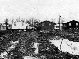
Contaminated groundwater was discovered in the Love Canal neighborhood of Niagara Falls, New York, in the late 1970s. Photo by the Center for Health, Environment & Justice.
Hooker bought the canal in 1947. It converted the site into a 16-acre landfill, covering the barrels and other trash dumped there with 20 feet of dirt. In 1948, the city stopped using the property and Hooker became the sole user.
In 1952, plans were drawn for construction on the site, so Hooker closed the landfill. During its 10 years of operation, the landfill was the dumping grounds for 21,000 tons of chemicals. After its closure, the site was covered with a clay seal to prevent leakage.
In the 1950s, Niagara Falls was experiencing a population boom and needed land for new schools and homes. The city at that time was on its way to its peak in 1960 of 102,000 residents.
In 1952, city officials convinced Hooker to sell their contaminated land to the school district for $1. Hooker executives did so but not before sending the city a 17-line disclaimer about the property and the dangers of constructing buildings on it.
The new 99th Street School was built anyway and opened in 1955 with 400 children attending. In 1957, home construction began on land the school district sold to developers. Eventually, 800 houses and 240 low-income apartments were built.
During all this construction, the clay seals on top of the covered landfill were breached, allowing chemicals to seep into the soil and water.
In 1976, the Niagara Falls Gazette began reporting on the long-forgotten dump site as well as complaints from residents about foul odors and black liquid in their neighborhoods. There were also reports of a high number of birth defects and miscarriages as well as illnesses such as epilepsy and migraine headaches.
One report stated that 58 percent of Love Canal children born between 1974 and 1978 had at least one birth defect. A 1979 EPA investigation concluded that 33 percent of Love Canal residents had chromosomal damage.
In 1978, 239 families were relocated. In 1981, another 700 families were sent elsewhere. The 99th Street School and another school were eventually demolished. In 1983, a $20 million settlement was reached between 1,300 former Love Canal residents and Occidental Chemical Corporation, which took over Hooker in the 1960s.
A $400 million Superfund cleanup of the neighborhood lasted until 2004. Most of the 21,000 tons of chemicals were left underground because transporting them was too risky. The landfill was covered with three feet of clay, a thick plastic sheet and 18 inches of topsoil. The groundwater is now guided through underground trenches.
In 2013, a half-dozen residents sued, saying chemicals were still leaking into their neighborhood.
The Love Canal incident is credited with inspiring action to clean up toxic sites across United States. It led to the passage of the 1980 Comprehensive Environmental Response, Compensation and Liability Act, which established the Superfund program.
Today, much of the neighborhood is overgrown fields and abandoned homes.
However, 150 acres east of the canal have been sold to companies for light industrial uses.
In addition, about 260 houses north of the canal were renovated and sold. The subdivision was renamed Black Creek Village. It has 39 wells monitoring groundwater quality. If you’re interested, you can purchase a home here for between $65,000 and $350,000.
Power and Beef in Buffalo
It’s less than a half-hour on southbound Interstate 190 to get from the Love Canal neighborhood to the community of Buffalo.
The city sits at the northeastern tip of Lake Erie in the northwest corner of New York. It’s where water from Lake Erie begins to drain into the Niagara River on its way to Niagara Falls and Lake Ontario.
Buffalo is the second most populous city in New York with its 274,000 residents. However, that’s a far cry from the 1950s when Buffalo was the 15th most populous city in the country with 580,000 people. It’s now in 81st place, just behind Reno, Nevada, and Gilbert, Arizona.
The median annual household income is $46,000 with a poverty rate listed at 27 percent. The city is no longer the industrial powerhouse it was for a century and a half, but with some financial help from the governor’s office it is trying to rebound.
Buffalo has an ethnic mix with 43 percent of its population listed as white, 33 percent Black and 12 percent Hispanic or Latino.
That diverse population became a target in May 2022 when Buffalo became the latest U.S. city to experience racially motivated violence. It happened on a quiet Saturday afternoon at one of the Tops Friendly Markets in town. Authorities say an 18-year-old white man drove 2 hours from his home in Conklin, New York, to the store, where he opened fire in the parking lot before entering the market and continuing to shoot. By the time the teen was arrested, 10 people had been killed. Authorities say the shooter, Payton Gendron, had posted a 180-page manifesto in which he discussed the “replacement theory” promulgated by some right wing extremists who say white people are being “replaced” in society by people of color. Authorities say Gendron targeted Black people during his rampage.
In June 2022, Gendron was charged with a multitude of federal hate crimes and firearm crimes along with the state charges of murder and hate crimes. In November 2022, Gendron pleaded guilty to murder and hate-motivated terrorism charges. In February 2023, he was sentenced to life in prison without parole after apologizing in court to the victim’s families.
The day after the massacre, community leaders held vigils and marches. President Joe Biden and first lady Jill Biden traveled to Buffalo three days after the deadly shooting.
This area along Lake Erie was home to the Iroquois tribe for centuries. It was explored by the French in the 1600s with the first European settlement being established in 1784. The Holland Company received approval in 1793 to purchase land. The Dutch firm began selling lots in 1801. The British burned down the town in 1813, but it was quickly rebuilt.
Buffalo grew significantly in the 1800s due to immigration, the construction of the Erie Canal, the railroads and the community’s proximity to Lake Erie. The city also had an abundance of fresh water and easy transportation corridors to the Midwest.
The industries that flourished included the shipyards, iron and steel mills, meat-packing plants, flour mills and railroad car manufacturing. The city’s population more than doubled between 1845 and 1855 from 30,000 to 74,000. At the time, the population was about two-thirds immigrants, mostly Irish and Germans.
Buffalo was also an important stop on the Underground Railroad. It was the northern terminus for a route that took fugitive slaves across Lake Erie and into Canada.
In the late 1800s, Buffalo was one of the first cities to embrace electric power, getting electricity from hydroelectric dams near Niagara Falls. It was also one of the first cities to have a widespread system of illuminated streetlights. It earned the nickname of the “City of Light.”
Its electricity industry brought to town in 1901 the Pan-American Exposition, which highlighted the achievements and culture of the Western Hemisphere. It was during this festival that President William McKinley was shot by an anarchist at a meet-and-great at a theater. McKinley initially recovered from his abdomen wounds, but he died 8 days later at a Buffalo medical center from gangrene and blood poisoning that had developed.
Vice President Theodore Roosevelt was rushed to Buffalo and sworn in as president at the home of Ansley Wilcox. The house is now the Theodore Roosevelt Inaugural Historic Site. The restored home was opened to the public in 1971.
Buffalo was also the hometown of two U.S. presidents. Millard Fillmore was born in the Finger Lakes region of New York and opened a law practice in Buffalo when he was 23. Grover Cleveland was raised in upstate New York and also practiced law in Buffalo. He was elected the city’s mayor in 1881 before becoming New York governor and then president.
In the 1900s, the grain, steel and automobile industries dominated the economy, many of them relying on the hydroelectric power from Niagara Falls. In the early 1900s, Buffalo was the 8th largest city in the country with 350,000 people.
In 1957, the St. Lawrence Seaway was constructed, diminishing the importance of the Erie Canal. The shipbuilding industry, led by the American Ship Building Company, faded in the early 1960s after being active since 1808. Further deindustrialization caused a decline in other manufacturing.
Today, Buffalo relies on light manufacturing, healthcare, research and high tech. Since 2012, money from the governor’s office known as the “Buffalo Billion” was helped rejuvenate some sectors of town. Another $500 million was added in 2017. That $1.5 billion helped pay for new waterfront parks and new factories as well as medical and technical offices.
The Buffalo Billion program has received its share of criticism. One of the chief targets is the $750 million, 88-acre RiverBend solar energy project owned by Tesla. Critics noted the plant was supposed to create 3,000 new jobs, but less than 700 had been filled by 2018. That number rose to about 1,800 in 2019 as the factory began making solar glass roofs.
Nonetheless, Buffalo remains a major gateway for commerce between Canada and the United States.

The eating contest at the National Buffalo Wing Festival in Buffalo, New York, where the dish was invented. Photo by Buffalo Place.
In addition, Amazon opened a 117,000-square-foot distribution center in the nearby town of Tonawanda in June 2020. When fully operational, the facility, located in the Riverview Solar Technology Park, is expected to provide 600 jobs as well as more deliveries opportunities for Amazon drivers. Local officials said the new business was particularly welcome in the midst of the economic hardships and the COVID-19 lockdowns.
Another Amazon distribution center is being planned in the nearby town of Niagara. More than 200 tractor-trailer trucks are expected to use the five-story, $300 million facility every day once it’s completed.
Buffalo has its weather quirks. It receives an average of 39 inches of rain and 85 inches of snow per year.
Despite its snowy reputation, Buffalo is not even in the top 10 snowiest cities in the state. The number one honor goes to the town of Oswego along Lake Ontario north of Syracuse with an average of 136 inches a year. In fact, Buffalo has the sunniest and driest summers of any major city in the Northeast with 155 sunny days per year on average. The temperatures reach an average of 80 degrees in July and 17 degrees in January.
Buffalo has its place in food history.
Buffalo chicken wings were invented in town in 1964 at the Anchor Bar. In the finger food’s honor, there is a National Buffalo Wing Festival held here in September.
Non-dairy whipped topping was also invented here in 1945 by Robert E. Rich, the founder of Rich Products Corporation. That company is still going strong and remains one of the city’s largest employers, although company officials said in April 2023 that they may move some jobs out of Buffalo over the next two years.

Charles Roesch, AKA Charlie the Butcher, is known for his friendly attitude toward his customers in Buffalo. Photo from Twitter.
However, it might not get more Buffalo than the Charlie the Butcher restaurant, known for its beef on weck sandwiches.
Charles E. Roesch started the business as Charles E. Roesch and Company in the city’s Broadway Market in 1914. Roesch also served as Buffalo’s mayor from 1930 to 1934.
His son, Charles J. Roesch, took over the restaurant and kept it in the Broadway Market for decades. His son, Charles W. Roesch, began running the place in the 1970s. He adopted the name Charlie the Butcher and changed the company’s title to the same moniker.
Roesch eventually moved Charlie the Butcher’s Kitchen to nearby Williamsville. He also started a catering service and operates a lunch shop called Charlie the Butcher Express in Endicott Square in downtown Buffalo.
Over the years, Roesch’s restaurant has been on Good Morning America, Live With Regis and Kathie Lee and the Food Network’s Food Nation with Bobby Flay. Their beef on weck sandwiches have even been part of Super Bowl bets involving the governor of New York.
Roesch’s wife, Bonnie Roesch, calls herself “Charlie the Butcher’s wife.” She says the beef on weck sandwiches’ unique taste is part of the reason for the restaurant’s success. It consists of tenderized roast beef on a kummelweck roll with seasonings that include pretzel salt.
“It’s a food marriage made in heaven,” she told 60 Days USA in spring 2021.
She added the restaurant has also been successful because of her husband himself. She said he is authentic, friendly, engaging and attentive. He’s known for slicing the roast beef in front of customers after they’ve ordered the sandwich.
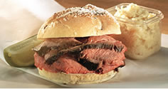
The famous beef on weck sandwich. Photo from Charlie the Butcher.
Charlie Roesch is now in his mid-70s and thinking of retiring, but his wife wants to start an online ordering business where they would ship out “six packs” of beef along with the weck rolls and seasonings. She promises that is coming soon.
Roesch notes she is Polish and married into a German family that uses its homeland recipes for its family-run restaurant. She says the family scene reflects Buffalo’s history of successful immigrants.
Both she and her husband grew up in Buffalo. She said they “love the four seasons” as well as the lake and the friendly, helpful community. Even though the city’s population has declined, there are still a lot of born-and-raised people who live in town. Roesch said people in Buffalo don’t ask you what college you attended. They want to know what grammar school and high school in town you went to.
She and her husband have no plans on leaving. They like being homegrown.
“You bloom where you’re planted,” Roesch said.
Tomorrow, we will have to pull up stakes and finally leave the state of New York as well as the Northeast in general, but not before we pay a visit to a small town known for its comedy legends.
Then, we begin our tour of the nation’s so-called Rust Belt states. The stops tomorrow will include the place where the U.S. oil industry was born, a town known for its famous groundhog and a place with one of the more somber memorials to the September 11, 2001 terrorist attacks.


