
Day 33: Water, Power and Pollution
April 21, 2021
Day 31: By the Time We Got to Woodstock
April 19, 2021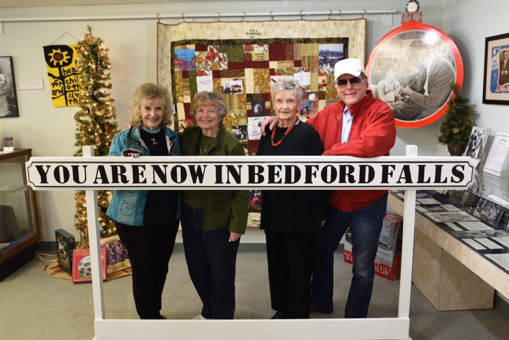
Most recently updated on February 2, 2024
Originally posted on April 20, 2021
We are in upstate New York all day today with plenty to see.
First on the agenda is a farm field that is forever engrained into music history.
So, we take Highway 28 west out of Woodstock and cruise around Ashokan Reservoir before we hit the winding roads that will take us through the Catskill Mountains, a part of the Appalachian system that was the setting for Washington Irving’s tale of Rip Van Winkle and is well known for its resorts and diners.

After an hour and half of motoring through beautiful hillsides and small towns, we reach the community of Bethel.
This village of 4,000 residents is where the 1969 Woodstock Music and Art Fair, as it was officially known, was held.
We’ll get to that in a moment. First, a little history.
The first European settlers arrived here in 1795 with the town being established in 1809.
During the 1800s, Bethel became a tourist destination with sleepaway camps and hotels that eventually became part of the Borscht Belt, a section of the Catskill Mountains where Jewish families took vacations between the 1920s and the 1960s.
This era was showcased in several episodes of the second season of the Amazon series “The Marvelous Mrs. Maisel.” The Catskills resorts were also the locale for the 1987 film “Dirty Dancing.”
Many famous comedians of the mid-1900s made their mark in the Borscht Belt. Among them were television pioneers Sid Caesar and Mel Brooks as well as comedians Jerry Lewis and Jackie Mason. Henny Youngman, Rodney Dangerfield, Buddy Hackett, Mort Sahl and Joey Bishop also performed at clubs here.
By the 1980s, the Catskills lure began to fade as airline travel allowed people to jet to faraway destinations and air conditioning made staying home in the summer an option to driving hours to get some cooler, mountain air.
The roots of the Woodstock concert began in a hamlet of Bethel known as White Lake. Elliot Tiber and his parents operated the El Monaco Hotel there. It so happens Tiber, who was the Chamber of Commerce president then, had a permit for a local art and music festival.
Tiber heard about the obstacles facing the promoters of the Woodstock festival after their concert plans had been rejected by officials in Woodstock and other Catskill towns. Tiber was happy to help and sold his permit for $1 to Woodstock Ventures for their outdoor concert.
The folks at Woodstock Ventures were introduced to Max Yasgur, who owned a 600-acre dairy farm outside Bethel. They struck a deal to hold the concert on Yasgur’s vast acreage.
The promoters sold 100,000 tickets. Two days before the event, 60,000 people had already showed up and were camped out. As the concert began, several hundred thousand more music lovers swarmed Yasgur’s farm field and the festival officially became a free concert.
From Friday evening, August 15, to Monday afternoon, August 18, as many as 500,000 people stood on the grassy field to hear 32 performances by well-known as well as emerging musicians. Richie Havens was the opening act and Jimi Hendrix closed out the show on Monday. In between were the likes of Janis Joplin, Jefferson Airplane, Joe Cocker, Joan Baez, The Grateful Dead, Santana, Creedence Clearwater Revival and The Who.
The concert was covered extensively at the time, but it became immortalized when the documentary film “Woodstock” was released in 1970.

The Bethel Woods Center for the Arts now sits on the site of the 1969 Woodstock concert in upstate New York.
In 2006, the Bethel Woods Center for the Arts opened on the site of the concert as an outdoor performing arts center that seats 15,000 people.
In 2008, the Museum at Bethel Woods opened near Yasgur’s farm to commemorate the Woodstock concert as well as the decade of the 1960s.
For a while, there was a Woodstock museum inside a store about three miles from the concert site. Art Vassmer and his wife, Marian, kept their Vassmer’s General Store open during the 1969 concert when other businesses shut down. Vassmer was known as “Mr. Woodstock.” He died in 1997. The store was sold in 2004 and turned into a restaurant.
Yasgur suffered damage to his farm from concert-goers. His neighbors also sued him for damage to their property. A year after the concert, Yasgur received a $50,000 settlement from the promoters. Two years after the festival, he sold the farm. In 1973, Yasgur died of a heart attack at the age of 53.
Tiber wrote a book in 1994 about his role in the concert entitled “Knock on Woodstock.” I actually met him that year when he was on his book tour. He was a guest on the morning news program I was producing at KPIX-TV, the CBS affiliate in San Francisco. Tiber died in 2016 at the age of 81.
Woodstock Ventures had been formed in 1967 by John Roberts, an heir to his grandfather’s Block Drug Company that invented Polident, and Joel Rosenman, a Yale law school graduate. They were looking to invest some of Roberts’ money in a business opportunity. They were introduced to Michael Lang, a head shop owner in Miami, Florida, who promoted concerts, and Artie Kornfield, the youngest vice president at Capitol Records.
The men, all in their 20s, formed their venture firm. The idea for the Catskills concert came from Lang and Kornfield’s desire to have a rural recording studio in the mountains.

The historic marker at the site of the 1969 Woodstock concert near Bethel, New York. Photo by TripAdvisor.
The Woodstock concert sold $1.8 million in tickets. However, their expenses were $2.8 million. The financial strain caused a split with Roberts and Rosenman buying out Lang and Kornfield.
Warner Brothers came to rescue with a $1 million payment for the documentary film.
Woodstock Ventures did well in the ensuing years. The main reason is they owned the rights to the images in the documentary film as well as the Woodstock trademarks that include the iconic dove on guitar logo. So, the company gets a piece whenever CDs, clothing, movies or other Woodstock-related products are sold. In 2009, that merchandise had crested at $50 million per year.
In 2019, Woodstock Ventures won a court case that gave them the rights to sell Woodstock-branded cannabis.
Roberts, Rosenman and Yang reunited to produce Woodstock ’94 and Woodstock ’99.
Roberts died in 2001 at the age of 56. Lang died in January 2022 at the age of 77.
However, Woodstock Ventures is still going strong.
In 2001, GlaxoSmithKline paid $1.2 billion for the Block Drug Company and its products that include not only Polident but also Nytol sleep aids and Tegrin shampoo.
Without those drug store products, it’s fair to say there might never have been a Woodstock festival.
——————————————–
The next hour and a half takes us on three mountain highways as we skirt the Pennsylvania border along the upper Delaware River and head toward the valley that served as the unlikely origin for the company we now know as IBM.
Along the way, we pass Cannonsville Reservoir, a 4,700-acre water storage facility near the town of Tompkins. Cannonsville is the westernmost and largest of the 19 water reservoirs owned by New York City. It’s also the newest.
The reservoir has a capacity of 95 billion gallons. Its maximum depth is 121 feet with an average depth of 61 feet. It sits at an elevation 1,151 feet.
The reservoir was formed in 1964 with the construction of the Cannonsville Dam, which snares half of the water in the western branch of the Delaware River. The dam’s waters submerged Cannonsville and four other towns along with 94 farms. The new reservoir displaced 941 people and forced the relocation of 2,150 graves from 11 cemeteries.
The Cannonsville water flows into the 44-mile West Delaware Tunnel and ends up in the 85-mile Delaware Aqueduct, which supplies New York City with 50 percent of its drinking water.
Under a 1954 agreement, New York City can take up to 800 million gallons of water per day from the Delaware River as long as it releases enough water into the lower Delaware for New Jersey and other downstream users.
The Cannonsville Dam is the site of a $34 million, 6-megawatt hydroelectric power plant that will provide electricity for 3,500 homes when it’s completed in 2025.
The reservoir is known for its brown trout and smallmouth bass fishing.
———————————–
The city of Binghamton is located just north of the Pennsylvania border where upstate New York begins to widen westward on its way to Lake Erie.
The community of 46,000 sits at the confluence of the Susquehanna and Chenango rivers.
The Iroquois tribe lived in the area for centuries. The first European settlers came as part of the Sullivan Expedition during the Revolutionary War in 1779. The armed force was sent by General George Washington to root out local residents as well as tribe members who were loyal to the British. The expedition helped clear the way for expansion into the Ohio Valley and Great Lakes region.
In 1786, William Bingham, a wealthy Philadelphia resident, purchased the patent for 10,000 acres in the area. He hired a land agent to develop the town. Roads and bridges were built. Available land for farming lured settlers and the village was incorporated in 1834.

The town of Binghamton, New York, where companies such as IBM and Whirlpool got their starts. Photo by Wikipedia.
In 1837, the Chenango Canal was built, connecting Binghamton to the Erie Canal. The Erie Railroad arrived in 1848 with the Delaware, Lackawanna and Western Railroad coming soon after.
Binghamton developed into a transportation hub and a manufacturing center for cigars, shoes, computers and 200 other products. By 1890, it was the second largest producer of cigars in the United States, behind only New York City. The town had 50 factories employing 5,000 people who churned out 100 million cigars a year.
In the early 1900s, the city’s largest employer was Endicott Johnson, a shoe manufacturer that employed 20,000 people in the 1940s to produce 52 million pairs of shoes a year. That included boots for soldiers during both world wars. The company also instituted an 8-hour work day and built employee housing as well as libraries, theaters and other community facilities.
Since World War Two, the area has lost much of its manufacturing industry with those jobs declining by 64 percent between 1990 and 2013.
The region made up for those losses during the Cold War period of the latter 1900s by bringing in the electronics and defense industries.
That economic adjustment actually began in 1906 when Harlow Bundy, the owner of a time recorder manufacturing business in Binghamton, moved his International Time Recording Company into a new three-story office complex in the nearby town of Endicott.
In 1911, ITRC and two other operations were merged into a new company called Computer-Tabulating Machine Company. It made punch-card tabulators and other office products.
In 1924, the company changed its name to International Business Machines, better known as IBM. The firm grew by manufacturing punch-card tabulating systems for government entities and private businesses that were tailored to each customer’s needs.
In 1933, IBM purchased Electromatic Typewriters Inc. and became an industry leader in electric typewriters.
During World War Two, the company developed high-speed electromagnetic calculators. In the 1950s, it pivoted from those products into electronic data-processing systems. By the 1960s, it was producing 70 percent of the world’s computers.
The growth of IBM had a big impact on the Binghamton area.
In the decade after the 1911 merger, the Endicott facility grew from 300 employees to nearly 1,000. By the early 1930s, the campus had expanded from five buildings to 25 buildings that encompassed 500,000 square feet and employed thousands of people. Besides producing products, the Endicott site also was a center of training for IBM employees.
At its height, the IBM facility was the region’s largest employer. The prosperity and an influx of immigrants earned Binghamton the nickname “Valley of Opportunity.”
There have been plenty of other business breakthroughs here.
The electronic flight simulator was created by Link Aviation. The device is used to train pilots, drivers and other professionals.
Valvoline was founded in Binghamton in the 1860s.
The Nineteen Hundred Washer Company was also located here. In 1939, the company moved its washing machine operations from Binghamton to Tennessee and eventually changed its name to Whirlpool.
Dick’s Sporting Goods began as a fishing store in town in 1948. The company headquarters was in Binghamton until 1994 when it moved its main offices to Pittsburgh.
At the end of the Cold War in the 1990s, the defense industry began to shrink. Among other changes, IBM sold its Federal Systems division and laid off thousands of employees.
The economy today in Binghamton is still driven by high-tech companies with IBM, Lockheed and others employing local residents.
Frito-Lay continues to operate a manufacturing plant in the region, too.
There’s also an education component. In particular, the Binghamton University downtown campus, which opened in 2007, has delivered a student population that has helped downtown businesses.
Incomes, however, are lagging. The median annual household income is under $40,000 and the poverty rate is 32 percent. Some of that may be due to the student population.
Binghamton is one of five towns that compete in the annual Golden Snowball competition, an award given to this part of upstate New York that receives the most snowfall. Binghamton, which receives an average of 85 inches of snow per year, won the contest in 2021. Buffalo captured the crown in 2022 and again in 2023.
Binghamton is also the location one of six Broome County parks that have carousels that were built decades ago by George Johnson, the owner Endicott Johnson. The carousels are free for people to ride between Memorial Day and Labor Day.
Salt, Canals, Women’s Rights, Wonderful Life
We head into the heart of upstate New York by traveling north on Interstate 81, an 850-mile freeway that begins in Tennessee.
After an hour and a half, we reach Syracuse, a community of 141,000 people and the fifth most populous city in the state. It also has quite an ethnic mix with 49 percent of its citizens listed as white, 29 percent as Black, 10 percent as Hispanic or Latino and 7 percent as Asian.
Syracuse has had a wide of variety of industrial successes throughout its history.
The first happened shortly after French missionaries came to the region in the 1600s to establish a mission for the Onondaga tribe.
While they were here, the missionaries noticed a salty brine in Onondaga Lake. Eventually, that resource was utilized. Syracuse became a major salt producer in the 1700s and 1800s. The town earned the nickname “The Salt City” in the 19th century because most of the salt used in the United States came from this region. At its peak, the city was producing 8 million bushels of salt a year.
The completion of the Erie Canal in 1825 and the arrived of the railroad in 1839 made it easy to transport salt. It also opened the door for other industries, especially after the salt industry declined in the late 1800s due to competition from Michigan and Canada.

The Salt Museum in Syracuse, New York, tells the history of that industry in the region. Photo by Exploring Upstate.
In 1881, the first Solvay Process Company plant was built on the shores of Onondaga Lake. The factory used the nearby brine wells and limestone quarries to produce soda ash for glass making. The operation eventually led to the establishment of an Allied Signal chemical facility in the area.
These plants stimulated the economy but also polluted Onondaga Lake. The body of water was declared a Superfund cleanup site in 1994. The Solvay plant closed in 1985, resulting in 1,400 layoffs.
The Franklin Automobile Company also had operations here. The firm produced the first six-cylinder cars, complete with air-cooled engines. Franklin rolled out vehicles from 1902 to 1934.
The Smith-Corona typewriter company set up shop in Syracuse in 1903, staying here until 1962. It was one of a number of typewriter companies with factories here.
After World War Two, the Carrier Corporation established its original headquarters in the Syracuse suburb of DeWitt. At its height, the company employed 7,000 people in its offices and factory. Carrier eventually moved its headquarters to Florida. It closed its plant in 2004 and then its warehouse operations in 2009. The company still employs 1,300 local residents at a research and design center.
Crouse-Hinds began operations here in 1897. They’re best known for making traffic signals, among other transportation-related products. General Motors had a manufacturing operation in the Syracuse area from 1923 until it closed the plant in 1993.
New Process Gears, which was once owned by Chrysler, closed its doors in 2012. It started out in 1888 as New Process Rawhide Company, making rawhide for gears. It eventually graduated to manual transmissions, adapters and compounders. The transfer cases the company produced were installed in sports utility vehicles that turned them from two-wheel to four-wheel drive. At its height in 2003, New Process Gears had $1.5 billion in sales as well as 4,000 employees and a $5 million weekly payroll.
General Electric had a 155-acre television manufacturing plant near Syracuse in a complex known as Electronics Park. The facility was initially completed in 1946 and television set production began in 1949. At one point, the factory was churning 24 hours a day, employing 20,000 people who produced 120 tv sets an hour. The television production operation was shut down in 1987, although the GE plant continued to do defense-related work into the 1990s. Lockheed Martin is now the industrial park’s anchor tenant.
Syracuse still remains a central distribution point for state agriculture, but it is not the manufacturing giant it once was.
The population of Syracuse has declined in recent decades. The local economy now relies on education, healthcare, research and services. The median annual household income sits at $43,000, about the same as Binghamton. Its poverty rate of 30 percent is similar, too.
The city is trying to mount a comeback.
In January 2019, the mayor announced plans for a $200 million “Syracuse Surge” in the southern portion of the downtown area. In October 2020, the city held a summit with industrial partners such as Microsoft to build a tech infrastructure. In February 2022, the program completed its first worker training session. In April 2023, a Syracuse Surge Accelerator project started to encourage Black, indigenous and people of color to launch or expand tech-related businesses. In October 2023, officials announced a program known as Surge Link to bring a free wireless community broadband network to lower-income neighborhoods.
The local industry is also getting a boost from the high-tech industry. Micron has unveiled plans to build a 1,400-acre semiconductor manufacturing plant just north of Syracuse with the assistance of the CHIPS and Science Act approved in August 2022. The four-facility complex is expected to generate 9,000 direct jobs when it’s completed. Construction is scheduled to start in 2024 with the first phase of the plant in operation in 2030.
There also had been talk of demolishing an old freeway in the city’s south side. This is one of many pockets in cities across the country where interstates were built on top of Black neighborhoods, destroying homes and businesses in the process. Some activists in Syracuse see this proposal as a way to revitalize some of these neighborhoods. In January 2022, the governor announced this section of Interstate 81 would be torn down and replaced with a “community grid” of local streets. The final details of the plan were signed in May 2022. However, the plans were put on hold by a New York state judge in November 2022 at the request of the organization Renew 81 for All so more study can be done on the environmental impacts of the project. The first contract for work on the demolition was awarded in January 2023 and some initial construction began in September 2023 as the environmental reviews continue.
The Syracuse area has a pair of museums of note.
One is the Salt Museum, located in the nearby village of Liverpool northwest of downtown. The facility documents the history of salt production here in the 1700s and 1800s.
The Erie Canal Museum spotlights how the waterway, which was built in 1825, made it significantly easier to transport goods from the Great Lakes region to the Atlantic seaboard. The museum is in a building where canal boats were weighed as they passed through the center of town.

The history of the “upside down” traffic light in Syracuse, New York, involves some stone throwing Irish activists. Photo by TalesAlongTheWay.
The canal is mostly used now for recreational purposes. However, the governor’s office is proposing a “Reimagine the Canals Initiative” to protect and invigorate the passage by mitigating flooding, restoring wetlands and creating recreational opportunities on the canal to boost tourism.
The city is also home to Syracuse University, which was founded in 1870. The college has been co-educational from the start with an emphasis on educating and encouraging women. The 22,000-student campus is now a major research institution.
The university is home to the Tree of 40 Fruit, which was planted in 2008. Every February, Syracuse University professor Sam Van Aken travels throughout New York, collecting 12-inch to 18-inch sections from various fruit trees. He then grafts them onto the Syracuse tree. When fully mature, the tree is expected to have 40 different types of stone fruit hanging from its limbs.
Finally, there’s the story of the upside-down traffic light, one that has a surprisingly strong political history.
The light is located on Tipperary Hill at the intersection of Milton Avenue and Tompkins Street west of downtown. When it was installed in 1925, it reportedly had the typical top-to-bottom row of red, yellow and green lights.
However, Irish youths from immigrant families didn’t like the red signifying the British on top with the green of the Irish on the bottom. So, they threw rocks at the signal and repeatedly broke the lights.
City leaders agreed in 1928 to switch the lights to their current slots to end the vandalism.
At least that’s how the legend goes.
There are remembrances to this past. There was a Stone Throwers Café near the intersection, but it appears that restaurant has closed. Nearby, there is still a Stone Throwers’ Park with a statue of some of the young rock tossers.
————————————-
We exit Syracuse by heading west on Highway 175 before connecting to westbound Highway 20.
We are now entering the Finger Lakes district of New York.
It’s so named because there are 11 lakes in this 9,000-square-mile region that when seen from above all look like fingers.
The lakes were formed in valleys with north-flowing rivers. Glaciers widened and deepened these gorges during the most recent Ice Age. Then, debris left over from the glaciers plugged the valleys, leaving behind these slivers of water.
The Iroquois tribe lived in this area for centuries. To them, the lakes looked like the fingers on the outstretched hands of one of their gods. European visitors began arriving after the Revolutionary War. Many formed religious or utopian communities in the quiet valleys.
The 11 lakes have a combined 650 miles of shoreline. None of them is more than 3.5 miles wide. Seneca Lake is the deepest at 618 feet. Cayuga Lake is the longest at 40 miles. All of the lakes are connected to rivers that lead to Lake Ontario.
The activities here include fishing, swimming, boating, kayaking and cruises.
This region of New York is also the state’s largest wine producing area with more than 140 wineries. It also has developed a major craft beer industry.
There are natural gas deposits in the area, but local residents have fought efforts to tap into them. In 2014, Governor Cuomo issued a statewide ban on fracking, eliminating any plans to drill for natural gas.
In July 2021, the people who live near Seneca Lake started speaking out against a nearby facility owned by Greenidge Generation. The complex houses more than 8,000 computers, many of which are used to “mine” the cryptocurrency known as bitcoin. They say the high-powered operation not only burns through a large amount of fossil fuels to create energy, it also is polluting and warming their treasured lake. In September 2021, Sen. Kristen Gillibrand asked the Environmental Protection Agency to investigate the Greenidge operation as part of the company’s application for renewal of its state permit. In April 2022, a decision on Greenidge’s permit was delayed for three months. In June 2022, state officials denied a necessary air permit for the facility. Company officials are appealing the decision.
——————————————
On this morning’s route, we drive past Skaneateles Lake and Owasco Lake on our way to Auburn, a community of 25,000 at the northern tip of Owasco Lake that has two famous homes as well as an old lab that was crucial in helping developing “talking pictures” in the early days of the movie industry.
This area was another one of the places the Iroquois lived. Auburn was founded in 1793 as part of a plan to provide land in central New York for soldiers who fought in the American Revolution. The land encompassed 1.7 million acres in 28 townships.
John Hardenbergh, a Revolutionary War colonel, was the first settler. He built a grist mill and a saw mill. A cotton mill was established in 1817 with a paper mill following in 1829. A wood mill joined the ranks in 1851.
The South Central Railroad arrived in 1871. Coal trains rumbled through towns traveling from Pennsylvania to Lake Ontario. The industry was assisted by abundant water power and cheap prison labor.
The inmates came from the maximum security Auburn Correctional Facility, which opened in 1816. The complex’s “Auburn style” of architecture and its disciplinary code were adopted by most other prisons in the country.

The former home of Secretary of State William Seward is now a museum in Auburn, New York. Photo by I Love NY.
The correctional facility was the site of the world’s first execution by electric chair when William Kemmler, who was convicted of murdering his common law wife, was put to death in 1890. The prison was also the place where Leon Czolgosz, the man who assassinated President William McKinley, was executed.
The prison caught flack from some critics who felt electrocution was cruel, especially since a second jolt of electricity was needed to kill Kemmler. Nonetheless, the prison has endured. Today, it houses 1,800 prisoners in five separate blocks.
The correctional facility has been a major employer in town. The city also still has a manufacturing sector. Products include steel, diesel engines, jet aircraft spark plugs, wire, air conditioners and glass bottles.
For a time, there was also a film industry in Auburn.
The Case Research Lab was the site of the development of the first “talking” motion pictures. In 1924, researchers here first began developing sound for film. In 1926, they formed a corporation for their invention they called MovieTone with the slogan, “It Speaks for Itself.” MovieTone debuted in 1927 with short films shown in New York theaters.
The Case Research Lab museum displays the equipment from that facility as well as a recording studio, chemistry laboratory and dark room.
There are also two homes in town that serve as museums.
The first is the Seward House Museum. The home was built in 1816 on four acres and served as the residence of William Seward from 1823 until his death in 1872. Seward was a senator and governor but is probably best known for being secretary of state under presidents Abraham Lincoln and Andrew Johnson. In 1867, he oversaw the purchase of the Alaska territory from Russia for $7 million in a deal that was initially labeled as “Seward’s folly” because of the remoteness and frigidity of that northern land.
Seward and his wife were also active in the anti-slavery movement. In the 1850s, they opened their house to runaway slaves as part of the Underground Railroad.
The museum displays the United States in the 1800s as seen through the eyes of the Seward family. It was bequeathed as a museum to a foundation in 1951. The museum opened in 1955 and was designated as a National Historic Landmark in 1964.
The other famous house is the Harriet Tubman Home.
The Sewards had a hand in this landmark, too. They sold the two-story brick residence for a modest sum to Tubman in 1859 to live in and use as a safe house for fugitive slaves. At the time, the transaction between a white homeowner and a Black buyer was illegal.
Harriet Tubman moved into the home after she had escaped to freedom in 1849 and became active in the Underground Railroad network.
The brick home was eventually demolished, but there is a museum now on the site. That facility was listed on the National Register of Historic Places in 1974. It sits in the middle of the 32-acre Harriet Tubman National Historic Park that was established in 2017.
Both Seward and Tubman are buried in Fort Hill Cemetery in Auburn.
———————————
A 20-minute jaunt westbound on Highway 20 takes us to our final destination.
Along the way, we pass through the Montezuma National Wildlife Refuge.
The 9,800-acre sanctuary at the north end of Lake Cayuga is one of the largest stopping points for nearly 1 million migratory birds on the Atlantic Flyway.
The birds that rest here include the great blue heron and the great egret as well as geese and ducks. The number of geese has reached as high as 100,000. There are also six bald eagle nests within the refuge. As many as 60 bald eagles have been spotted.
The Atlantic Flyway starts in Greenland and travels 3,000 miles along the Canadian and Atlantic coasts to the warmer climates of the Caribbean and South America. It’s the most densely populated of the four flyways in the United States. This particular causeway is popular with birds because there are no significant mountains. There’s also plenty of food, water and shelter.
The Montezuma refuge was officially established in 1938. It was designated as a National Historic Landmark in 1973. There have been Harmony with Nature concerts held on the refuge grounds.
As we exit the refuge, it’s just a few more minutes along Highway 20 before we reach Seneca Falls.
This community of nearly 9,000 has a rich history of women’s rights as well as an inspiring connection to one of America’s most endearing classic films.
The region was inhabited by the Cayuga tribe before troops from the Sullivan Expedition pushed out these native dwellers in 1779. The town was first settled by Europeans in 1787 as part of the same program for former Revolutionary War soldiers that helped found Auburn.
The Great Western Road came through Seneca Falls in 1794. The Seneca Road Company was formed to help maintain the roadway.

One of the exhibits inside the Women’s Rights National Historic Park in Seneca Falls, New York. Photo by the Seneca Falls Development Corporation.
This growing community had easy access to water. In 1818, canal locks were built along the Seneca River. In 1828, the Cayuga-Seneca Canal was linked to the Erie Canal, making the transportation of goods much easier.
By the early 1830s, there were five saw mills, five flour mills, three tin/sheet iron plants and two textile factories. In addition to the canals, products could also be transported along the Rochester-Auburn Railroad starting in 1841. In the 1900s, manufacturers such as Gould’s Pumps, Sylvania and Seneca Machine continued to operate.
These industrial endeavors gave women an opportunity to work, which helped make Seneca Falls a center for women’s rights.
In July 1848, the Seneca Falls Convention was held here. It was the first women’s rights convention and helped launch the suffrage movement that led to the 19th Amendment in 1920 guaranteeing women the right to vote.
About 300 people attended the convention. On the first day, only women were allowed in. Before they were done, convention members approved 11 resolutions on women’s rights ranging from voting rights to property rights.
Today, the town is home to the 7-acre Women’s Rights National Historic Park. The park was founded in 1980 and includes the Wesleyan Methodist Church where the Seneca Falls Convention was held as well as a visiting center with statues and information on important women in U.S. history.
The park also contains the home of Elizabeth Cady Stanton, one of the leaders of the Seneca Falls convention. The mother of seven children was also president of the National Woman Suffrage Association for 20 years.
Across the Cayuga and Seneca Canal from the park is the National Women’s Hall of Fame, which honors women of all eras. The inductees now number more than 300 and range from first lady Abigail Adams to author Louisa May Alcott to poet Maya Angelou to comedian Lucille Ball to chef Julia Child to pilot Amelia Earhart. The hall is located on the first floor of the historic Seneca Knitting Mill.

The “It’s a Wonderful Life” Museum in Seneca Falls, New York. Photo from the Wonderful Life museum.
Seneca Falls is also believed to be the inspiration for Frank Capra’s Bedford Falls in the 1946 movie “It’s a Wonderful Life.”
There’s an It’s a Wonderful Life Museum. Among the artifacts here are items from the collection of actress Karolyn Grimes, who played Zuzu in the film. There’s also a call sheet from the filming as well as an Academy Awards program from the year the movie was nominated. The museum opened in 2010 in the Seneca Theater, which was built in 1913 and was the first movie house in town.
An It’s a Wonderful Life Festival is celebrated at the museum every December. The 75th anniversary of the film was held in December 2021. Among the special guests were Grimes, Jimmy Hawkins (Tommy Bailey), Jeanine Roose (Young Violet Bick) and Carol Coombs (Janie Bailey), who made her 10th appearance at the event.
The Bridge Street Bridge is thought to be the model for the bridge in the scene in the movie where George Bailey is contemplating suicide. In 1917, an Italian canal worker saved the life of a woman who had jumped into the waters in a suicide attempt. The worker saved the woman, but he drowned because he didn’t know how to swim. Every corner of the bridge has a Wonderful Life theme.
There’s also a “Bells for the Real Bedford Falls” fundraising campaign where you can buy a bell for $20 and have it rung at the December festival. There are also bells that are hung by individuals across the span of the Bridge Street Bridge.
Tomorrow, we will take in our final full day in New York with another famous home connected to the women’s rights movement as well as the country’s most famous waterfall and the neighborhood that was the site of one of the nation’s most infamous environmental disasters.