
Day 15: Peanut Butter and Pirates on the Road to Florida’s Coast
April 3, 2021
Day 13: The Colorful Road to The Big Easy
April 1, 2021
Most recently updated on April 6, 2024
Driven on April 4-6, 2024
Originally posted on April 2, 2021
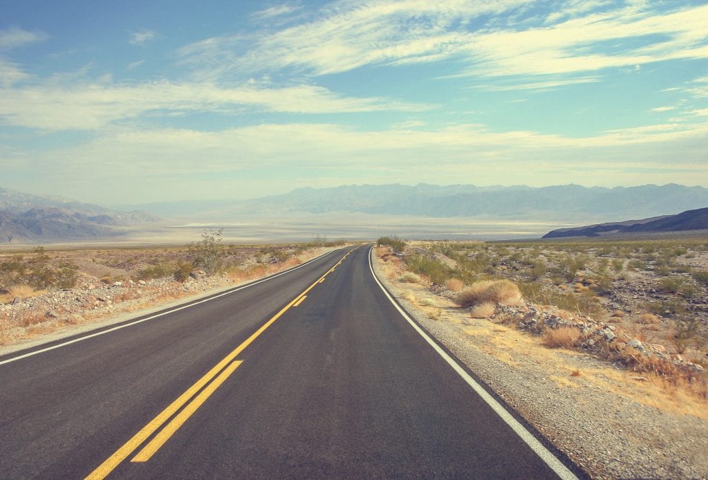
We’re back on Interstate 10 this morning, heading east to begin the Day 14 leg of our journey.
As you leave behind New Orleans, you drive along the southern shores of Lake Pontchartrain and cross its waters to the final bayous and wilderness areas of southeastern Louisiana.
From here you get an expansive view of this edge of the Louisiana coast.
This marshy shoreline is constantly changing and now it’s in trouble.
In 2017, the state’s Coastal Protection and Restoration Authority (CPRA) released a master plan for Louisiana’s coastline that outlines the problems and solutions.
The report noted that Louisiana lost 1,800 square miles of land between 1932 and 2010. That’s an area about the size of Delaware.
The erosion doesn’t appear to be letting up either.

Concerns are being raised about the amount of land that is slowly being submerged along the southern Louisiana coastline. Photo by pri.org.
Another report estimates Louisiana currently loses a football field of land to the sea every 90 minutes.
Among the causes listed in the CPRA master plan are hurricanes, sea level rise, climate change and human behavior.
The plan explains that the levees and dams along the Mississippi have helped control flooding. However, this system of barriers has also kept the river within its banks, depriving the coastal ecosystem of downriver sediment, nutrients and fresh water.
A report released in March 2021 stated that about half of the 440 million tons of sediment that used to flow down the Missouri and Mississippi rivers to the Louisiana coast no longer makes it this far. Much of it is trapped behind dams in places such as South Dakota and Nebraska.
Basically, the lack of sediment reaching the southern end of the Mississippi is no longer replacing land that is now getting submerged by rising sea levels.
In addition, the plan states that dredging canals for oil and gas exploration has provided the nation with energy supplies, but it also altered wetlands and disrupted hydrology. That has also led to land loss. The document adds that navigation channels that permit ships to travel upstream have allowed salt water to invade deeper into coastal basins.
The 2017 master plan predicts the state will lose another 2,250 square miles of land the next 50 years if no action is taken.
The CPRA has been working on some solutions.
Since the first master plan was implemented in 2007, the agency has constructed and/or funded 135 projects that have benefitted 36,000 acres along the coastline. Among the projects are 282 miles of levee improvements and 60 miles of barrier islands and berms. It also lists $18 billion for marsh creation and $5 billion for sediment diversions.
A $1.4 billion plan is in the works. It involves punching eight holes in Mississippi River levees and two more along the Atchafalaya River. The openings will be gated and made into channels. The idea is to let the Mississippi River pour through at strategic times, dumping sediment along coastal land.
In March 2021, the Army Corps of Engineers released an environmental impact report on a plan to cut a hole in a levee southeast of New Orleans and channel Mississippi River water into Barataria Bay. The diversion would create thousands of acres of freshwater marshes and lessen storm surges into New Orleans. However, critics say it will harm the shrimp and oyster industries as well as dolphins and some nearby communities.
A United Nations report released in April 2022 noted that rising sea levels from climate change is also damaging the shorelines along the Gulf of Mexico.
In January 2023, the CPRA unveiled an updated $25 billion plan that includes 61 projects for dredging, restoration and protection.
A February 2024 report stated that there has been a burst of sea level rise along the Louisiana coast in the past 13 years. The report authors said the state’s wetlands could be gone by 2070, eliminating the natural buffer Louisiana has against hurricanes.
Coastlines and Casinos
After a few minutes, you grab one last look at the Louisiana coastline and cross the border into the state of Mississippi.
This is a state of lowlands and inland forests. That’s evident as you enter the state and are greeted by marshland covered by thick groves of relatively short trees.
Mississippi is also a state mostly made up of smaller, rural towns.
The capital of Jackson is the most populous with 138,000 residents. It’s the only town with more than 100,000 people. The state’s total population of 2.9 million is 35th among states.
The mean elevation is only 300 feet, the 45th lowest in the United States.
The Magnolia State was once an economic powerhouse.
During the first half of the 1800s, it was the top cotton producing state in the nation. It was also the 5th wealthiest state, mainly due to its plantations.
That economy was propped up by a large contingent of slaves. In the 1860s, 55 percent of Mississippi’s population were listed as slaves.

That’s probably the main reason Mississippi was the second Southern state to secede from the Union. It did so on January 9, 1861, just 20 days after South Carolina’s withdrawal and one day ahead of Florida.
After the Civil War, there were incidents of discrimination and violence against newly freed Black residents.
Despite this mistreatment, Mississippi still had a majority Black population until 1930.
That changed during World War Two when Black Mississippians headed to the West Coast to work in shipyards. Despite that migration, Mississippi’s Black population still stands at nearly 37 percent, one of the highest percentages of any state.
Mississippi is also ranked 49th among the states in general health outcomes in a 2022 report, ahead of only Louisiana. Its median annual household income of $48,000 is 50th among states. It has a workplace participation rate of 56 percent, ahead of only West Virginia. Mississippi’s state government is also the fourth most dependent on federal funds.
Part of the problem is Mississippi’s economy for the most part didn’t change with the times.
The state continued to rely on agriculture after the Civil War when other states started to adjust to the Industrial Revolution. Mississippi didn’t invest in infrastructure or education.
Today, Mississippi is still the fourth leading cotton producing state. It’s also in the top tier for soybeans. It produces 60 percent of the nation’s farm-raised catfish and is a leading state for shrimp and broiler chickens.
It does have some manufacturing industries. The state is second in furniture production and third in chemical products.
The state has tried in recent decades to diversify its economy.
Just after you cross the Pearl River that serves as the Louisiana-Mississippi border, you can see the John C. Stennis Space Center north of Interstate 10.
The center is one of 10 NASA field offices in the country. It’s the country’s prime rocket engine test complex. All the Apollo launchers and space shuttle engines were tested here, including the rockets that sent Neil Armstrong and other astronauts to the moon.
For the future, the Stennis center will test NASA’s new Space Launch System rockets. These vessels will someday carry humans deeper into space than ever before.
The center was named after John C. Stennis, a Mississippi senator who opposed civil rights legislation as well as the 1954 Brown vs. Board of Education school desegregation decision. A campaign began in June 2020 to rename the complex after someone else.
The effort was started the same day that NASA announced it was renaming its Washington, D.C., headquarters after Mary Jackson, the agency’s first Black engineer. Janelle Monae played Jackson in the movie “Hidden Figures.”
NASA isn’t the only place where this is happening.
Colleges, cities, states and other jurisdictions are being asked to rechristen buildings that now bear the names of people who activists say supported segregation and other racist policies in the past. We’ll examine these local debates in coming weeks as this journey continues. In January 2024, defense department officials announced they have completed the renaming of 33 ships, buildings and streets that were considered to be honoring the Confederacy.
Not everyone in Mississippi agrees with the movement.
Stennis was a Democratic senator from 1947 to 1989. He was a strong supporter of the military, but he also voted against the 1964 Civil Rights Act and the 1965 Voting Rights Act.
His views did soften over the years. In 1982, he voted in favor of extending the Voting Rights Act. He also supported Mike Espy’s successful 1986 campaign to become Mississippi’s first Black congressional representative since Reconstruction.
Stennis died in 1995 at the age of 93.
NASA officials say they are reviewing the request to rename the center. His daughter said the move to rename the center as well as the USS John C. Stennis battleship are “going too far.”
When the center first opened almost 60 years ago, it wasn’t named after Stennis. It was renamed in his honor in 1988 under an executive order signed by President Ronald Reagan.
The facility was originally called the Mississippi Test Operations when NASA announced in 1961 the rocket site would be built in Hancock County. At the time, the center was the largest construction project in Mississippi history.
The 13,500-acre site was a near perfect location for a large test facility. It had access to the East Pearl River, a water system essential for transporting large rocket stages and propellants. It was also an isolated area, so it could provide a 125,000-acre sound buffer.
It did require the relocation of 600 families of NASA employees to an area where only a few thousand people lived. Construction began in 1963 and in 1966 the center started testing rockets.
The facility was a big deal for Mississippi’s economy. A 2019 NASA report stated that the Stennis Center generated 3,600 jobs in the state as well as an economic output of $570 million.
The center also helped create the city of Diamondhead just a few miles east on Interstate 10.
There wasn’t any significant settlement on this acreage an hour outside New Orleans before 1970.
That didn’t discourage officials from the Diamondhead Corporation, a large company with resort developments in other states. In 1969, the developers purchased 6,000 acres of vacant property along a newly constructed section of Interstate 10.
They saw the potential for a community along the Gulf Coast not too far from where hundreds of people were working at a large NASA facility.
They began laying out the town and by June 1973, they had sold 3,700 lots for homes. By then, 31 homes had been completed and 29 others were under construction.
Eventually, a marina, a golf course, a country club and an airport were also built.
At first, Diamondhead served as a retirement community. Over the years, however, it morphed into a town for working families as well as seniors.
In 2012, a group of residents succeeded in having Diamondhead incorporated as a city.
Today, the community has 9,300 residents, 85 percent of whom are white. The median annual household income is $80,000 and the median age is 50. The poverty rate is listed as 5 percent. All statistics unusual for Mississippi.
The city has tried on several occasions to have a casino built, but these efforts have come up short.
One of the most high profiles efforts came in 2006 when a New York real estate developer named Donald Trump proposed building a casino resort in Diamondhead the year after Hurricane Katrina seriously damaged the south side of town.
The 400-acre site owned by Diamondhead Casino Corporation seemed like an ideal locale for a gambling resort. It would have been the only casino along Interstate 10. It also sat along 2 miles of shoreline.
However, the deal between Trump and Diamondhead fell through in 2007.
In 2014, the property received an initial site approval from the Mississippi Gaming Commission. However, a casino projected never materialized and Diamondhead put the property up for sale in April 2019.
The setback is unusual for Mississippi.

The Island View Casino Resort in Gulfport is one of 38 casinos now operating in Mississippi. Photo by HRS.
The state is home to 38 casinos that have a total of more than 37,000 slot machines and more than 1,000 table games in 14 different cities. Mississippi is 8th among states in casino revenue.
The first casino opened in 1992 and since then the industry has paid more than $6 billion in state and local taxes.
The largest of these casinos is in Gulfport, just a half-hour east of Diamondhead along Interstate 10. It’s the second most populous city in Mississippi with 71,000 residents.
The Island View Casino Resort opened here in 2006. It contains 83,000 square feet with nearly 2,000 slot machines, more than 40 gaming tables and 970 rooms in two hotels. Island View is one of two casinos in Gulfport.
This area has changed quite a bit since it was first inhabited by the Choctow tribe. French explorers arrived in the 1700s. The town was founded in 1887 by Captain William H. Hardy as a terminus for the Gulf and Ship Island Railroad.
The Gulfport harbor opened in 1902. At first, it was primarily used to transport lumber. Then, it handled banana imports from Dole and Chiquita. Today, it’s the third largest container port on the Gulf of Mexico.
Gulfport was seriously damaged by Hurricane Camille in 1969 and Hurricane Katrina in 2005, but it has bounced back. It also suffered some flooding as did other Mississippi coastal towns when Hurricane Ida hit in late August 2021.
Tourism remains a primary industry in Gulfport. The city is the locale for 6.7 miles of human-made white sand beaches along the Mississippi Sound. Some of the waters are known for their bottle-nosed dolphins and seals.
Gulfport is also the host of the Mississippi Deep Sea Fishing Rodeo. The event is held during the July 4th weekend. The contest was first held in 1948 and now has 5,000 entrants from a dozen states during a typical year. Competitors are allowed to fish anywhere in the Gulf of Mexico and Mississippi Sound. There are 22 categories for saltwater fishing and six for freshwater.
Not too far up the road is Biloxi. You get to this community of 48,000 people by taking Highway 90 east out of Gulfport for a half-hour jaunt along the Mississippi waterfront, where you are treated to a panoramic view of the Gulf of Mexico and its human-made white sand beaches.
The Biloxi area has 11 casinos spread along its Gulf coast, the most of any region in the state. Gambling along with tourism and the seafood industry are the drivers of the local economy.
Biloxi has an interesting history that includes segregation, music and fishing.
Native American tribes settled here close to 10,000 years ago. The first Anglo visitors were French explorers in 1699. The town was developed in the 1800s as a resort community with summer homes along its beaches.
In 1881, the town’s first cannery was built to process seafood. In 1890, there were 2 million pounds of oysters and 614,000 pounds of shrimp processed in Biloxi. By 1902, that had risen to almost 6 million pounds of oysters and 4.4 million pounds of shrimp. In the 1920s, 40 seafood factories were operating in two cannery districts. Biloxi was known then as the “Seafood Capital of the World.”
During World War Two, Keesler Air Force Base was built as a basic training and aircraft maintenance facility. The economy, however, was still dominated by the shrimp and oyster industries.
Gambling came to town after the state approved the gaming industry in 1992. The state’s first casino, the Isle of Capri, opened that year in Biloxi.
Biloxi has been hit hard by hurricanes. In 1969, Hurricane Camille ripped through the town. In 2005, Hurricane Katrina damaged 90 percent of the buildings along a large part of the Mississippi coastline. The population of the region dropped as people decided to leave this hurricane-prone region.
After Katrina, Biloxi fell from the state’s third most populous city to its fifth most populous.
In addition to hurricanes, Biloxi has a long history of racial strife.
You get a glimpse of that history as you enter town.
On the western edge of the city is the Jefferson Davis Presidential Library and Museum at the former Confederate president’s Beauvoir estate. The presidential library here contains documents on the history of the Civil War as well as the Confederacy. There’s also an “unknown soldier” monument built to memorialize Confederate soldiers who died.
During a visit in April 2024, Bill Thompson, a friendly and knowledgeable tour guide, showed visitors the various rooms of Beauvoir, as the home is known. It was built in 1848 and had several owners before Davis and his family moved in slightly more than a decade after the Civil War. Davis spent his final years there.
Thompson told 60 Days USA he likes to educate the public about the Davis family, informing people of things they may not know. If you ask him, he will tell you that the Civil War was fought over states’ rights and not slavery. He also says Davis and other Confederate leaders were not guilty of any crimes because the U.S. Constitution allowed states to secede if they had serious disagreements with the federal government.
The Davis home is the subject of criticism. There are those who feel it should not be called a presidential library. Others feel it is one of numerous institutions that promote what is known as the Lost Cause, a movement to portray the South’s defeat in the Civil War as a heroic war effort. We’ll discuss the Lost Cause and what critics have to say about it in another southern location in a few days.
In 1959, racial prejudice reared its head quite publicly in Biloxi.

The Biloxi Lighthouse is one of the landmarks along the Mississippi coastline. Photo by the Biloxi Sun Herald.
It was that summer when a Black doctor along with another Black man and five Black children were ordered to leave a segregated public beach. That led to a series of protests on the region’s beaches known as the “Biloxi Wade-Ins” where Black citizens ignored segregation laws and walked into the water of white-only beaches. The protesters were attacked by white groups in 1960 and 1963. The beaches weren’t integrated until 1968 when a court struck down the restrictions. A civil rights marker now stands along the beachfront.
Another historic marker in town is the Biloxi Lighthouse, which was erected in 1848. The cast-iron complex has been home to several female lighthouse keepers over the years. The 65-foot-high structure has also survived all the hurricanes that have slammed into the Mississippi coast. It was added to the National Register of Historic Places in 1973.
On a more artistic side, Biloxi is also known for music.
It’s part of the blues culture that Mississippi takes pride in. The state labels itself as the “Birthplace of the Blues” and has created a Mississippi Blues Trail. The trail of historic markers runs south to north through the state and includes a “Biloxi Blues” marker that pays tribute to the city’s blues history, in particular the clubs and cafes that catered to Black customers during and after World War Two.
Biloxi itself was the focus of the compilation album by singer Jimmy Buffett titled “Biloxi.” Buffett, who was born in nearby Pascagoula, opened the Margaritaville Casino and Restaurant in Biloxi in 2012. The establishment only lasted two years, closing in 2014.
In addition, the town was the setting for the 1984 Neil Simon play, “Biloxi Blues.” It’s also the locale for several novels by Mississippi State University graduate John Grisham, including “The Runaway Jury” and “The Partner.”
——————————————-
It’s back to Interstate 10, heading east through southeast Mississippi.
After a few minutes, you pass north of Pascagoula and cross the state line into Alabama.
The Yellowhammer State, nicknamed after the state bird, has some of same characteristics as Mississippi.
Like its neighbor, Alabama doesn’t have many towns with more than 100,000 people. Its most populous is Huntsville with about 227,000 residents. The state’s total population of 5 million places it in 24th place. It’s a state that’s listed as 64 percent white and 26 percent Black. It has an annual median household income of slightly less than $60,000.
Alabama also sits in the middle of the South’s Bible Belt with Protestant Christians dominating the religion scene. The Southern Baptist Conference has about 1 million members statewide. That’s a fifth of the population. A 2016 Pew Research Center report put Alabama in a tie for first with Mississippi among the most religious states with 77 percent of residents saying they were “highly religious.”

As you enter Alabama, Interstate 10 takes a slight bend toward the north. A half-hour after breezing past the state line you come to the city of Mobile.
Mobile sits in a small rectangle of southwestern Alabama wedged between Mississippi and the panhandle of Florida.
More importantly, the city is situated in the northwest corner of Mobile Bay. The history of the city as well as its economics are closely tied to this large body of water that sticks up from the Gulf of Mexico.
Mobile was founded in 1702 as the first capital of the French Louisiana territory. It had an early setback in 1704 when 23 French women arrived on a ship known as The Pelican. King Louis XIV had ordered the women to travel to this new land to help settle it. The women known as “Pelican Girls” unknowingly carried yellow fever. The women all recovered from the viral disease, but a number of local residents as well as Native Americans died.
Mobile officially became part of the United States in 1819 with the annexation of West Florida from Spain.
The city quickly became a major port for the shipment of cotton grown in nearby areas. The Mobile & Ohio Railroad arrived just before the Civil War. Timber became the city’s top export in the 1880s.
In the early 1900s, the port was expanded. The Alabama State Docks along Mobile were completed in 1922.
In the 1930s, the red fire ant was introduced into the United States via Mobile’s port. The ants may have arrived in the soil that incoming ships used as ballast. The ants invaded Mobile and then spread throughout the South and Southwest.
During World War Two, shipbuilding and other defense industries boomed in Mobile and 90,000 people came to town to work.
After the war, the defense sector declined, but the paper and chemical industries picked up the slack.
The one military installation that kept going for a few decades was Brookley Air Force Base. It opened in 1940 and was the city’s leading employer during World War Two.
The base was also part of Operation Ivory Soap, a ship remodeling project that became essential to the U.S. victory over Japan in the Pacific war theater. In 1944, workers at the base began refurbishing 24 ships to serve as floating repair stations for ships damaged during the U.S. military’s “island hopping” campaign to conquer Japan.
The men who worked on the floating stations were trained at the Grand Hotel in Mobile. The name for the operation was created after some of the trainees noticed that Ivory soap floated in water just like their refurbished ships.
The Brookley base closed in 1969. The closure was one of the factors behind an economic downturn in Mobile in the 1970s and 1980s. In the late 1980s, city leaders started the “String of Pearls” initiative to lure new businesses and revitalize the downtown area.
Today, aerospace, steel, shipbuilding and manufacturing are among the main drivers of the economy.
The Port of Mobile remains an economic engine. In 2021, the volume of traffic at the port’s container terminal rose 19 percent to reach a new record. The port saw another increase in traffic in 2022. Officials credit the historic volume to the port’s lack of congestion and delays.
The 41-berth facility is the 9th largest port by tonnage in the United States and the only deep water port in Alabama. Port officials estimate it supports 312,000 jobs and $85 billion in economic value annually to Alabama.
The 3,600-acre complex has upper and lower ports that handle 55 million tons of cargo per year. The port is undergoing a $350 million expansion that will make it the largest port on the Gulf of Mexico.
One of the big components at the port is Austal USA, which opened up shop in Mobile in 1999. Its 164-acre shipbuilding facility employs 3,000 people. In March 2021, the company held a groundbreaking for a new $100 million steel shipbuilding facility in Mobile that will produce vessels for the U.S. Navy and Coast Guard. That facility opened in April 2022. Plans to add another 192,000 square feet at the Austal facility to build larger steel ships were announced in February 2024. Construction is expected to begin in summer 2024.
The port has allowed Mobile to grow to a population of almost 180,000, making it the 4th most populous city in the state. Its population is 53 percent Black and 40 percent white.
The majority Black population stems partly from the fact that Mobile’s history is also closely connected to slavery.
The first African slaves arrived here in 1721. That first ship left Africa with 240 slaves on board. Only 120 survived the voyage.
Mobile was Alabama’s main slave trading area until the Civil War. In 1860, Mobile’s population was 45 percent slaves.
In 1902, city leaders approved segregation laws that included street cars. The restrictions led to civil unrest and boycotts.
In 1963, three African-American students won a court decision allowing them to attend the all-white Murphy High School. The case led to the desegregation of city schools.
Perhaps the most poignant reminder of Mobile’s racial history comes in a neighborhood in the northern part of the city known as Africatown.
The history of this community is linked to the Act Prohibiting Importation of Slaves that was approved by Congress in 1807. The law forbade the importation of captured slaves from other parts of the world.
At the time, there were 4 million African slaves in the United States. Southern states that depended on the free labor felt they could sustain their agricultural economy simply by having the children of slaves become slaves themselves.

The remains of The Clotilda, the last known slave ship to dock in the United States, have been found in Mobile Bay, Alabama. Photo by the Smithsonian Magazine.
The new law, however, did not stop the illegal importation. It’s estimated that 50,000 slaves were secretly transported to the United States after the 1807 act was approved.
The final batch of those captives came aboard the Clotilda, the last known slave ship to dock in the United States. The Clotilda arrived in Mobile Bay in 1860 with 110 captured Africans on board. The owners of the Clotilda apparently burned and sank their ship in the bay to cover up their smuggling efforts.
After the Civil War, some of the newly freed slaves from the Clotilda formed a community in an area known as Magazine Point. Over the ensuing decades, the neighborhood’s population was made up almost entirely of children and grandchildren of the original founders. The musician Questlove is a descendant of one of the Clotilda escapees.
The community carried on African traditions, including the utilization of a medicine man until World War Two.
In 2012, the neighborhood was listed on the National Register of Historic Places.
Africatown’s population has fallen from 12,000 in the 1960s to less than 2,000 today. Most of the homes here have been torn down and replaced by factories. The residents held a festival in February 2019 to remember the town’s origins.
The Clotilda, it turns out, did not disappear. The sunken ship’s remains were discovered a few years back and were officially identified in 2019. There has been some talk of creating a memorial at the site.
A 60 Minutes report in November 2020 detailed the voyage of the Clotilda as well as the rise and fall of Africatown.
A documentary titled “Surviving Clotilda” debuted in October 2021. It tells the story of the people who survived that trans-Atlantic voyage.
In July 2023, a museum was dedicated in Mobile that tells the history of the Clotilda.
There is a group that is trying to do something about rundown and abandoned properties in Mobile.
In 2019, the members of Innovation Team Mobile conducted a survey of run-down and blighted homes and properties in the city. Some of the sites mapped were in Africatown. The purpose was to address the scope of the blight and its impact on the Mobile.
With this information, city officials and team members have set up programs to supply grants to homeowners to clean up their properties as well as legal services for people to properly leave their homes to their designated heirs. Some vacant homes are being demolished.
The Mobile team is part of a project funded by Bloomberg Philanthropies designed to set up Innovation Teams to help city leaders across the nation find solutions to nagging problems.
Before we depart, we should some of the long list of well-known people with ties to Mobile.
They include Tim Cook, the chief executive officer of Apple, who was born in Mobile and raised in rural Alabama.
Laverne Cox, one of the stars of “Orange is the New Black,” was born in Mobile. Her mother still lives here.
A number of Hall of Fame baseball players are from Mobile.
Hank Aaron grew up here. His childhood home is now a museum and a local sports stadium is named after him.
Willie McCovey was also a Mobile native as was legendary pitcher Satchel Paige and shortstop Ozzie Smith.
————————————————
Out of Mobile, our route heads northeast on Interstate 65.
The 887-mile freeway connects the Deep South with the Midwest.
It begins at the Gulf of Mexico in Mobile and cuts through Montgomery, Nashville and Louisville before crossing the Ohio River over the Abraham Lincoln Bridge on its way to Indianapolis and its northern terminus at Gary, Indiana, on the shores of Lake Michigan.
The interstate is known here as “Alabama’s Main Street.”
This particular section of I-65 takes you through the pine forests and rural stretches of southern Alabama.
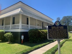
The Hank Williams Sr. Boyhood Home in Georgiana, Alabama
After an hour and a half, you come upon the small town of Georgiana.
The community was founded in 1855 after the Louisville and Nashville Road was built. The Rev. Pitt S. Milner opened a store here in 1858. He named the settlement after a combination of his daughter’s name and his home state of Georgia.
Like many Alabama towns, the main industry for decades here was cotton. Today, the economy is driven in large part by manufacturing.
Georgiana’s claim to fame is that legendary country western singer Hank Williams Sr. lived here as a child. His former residence is now the Hank Williams Sr. Boyhood Home and Museum and the community holds a Hank Williams Festival in June.
On a visit in April 2024, we were greeted by tour guide in a rocking chair. Leona Simmons grew up in Alabama and has lived in Georgiana since she was 11. She has worked at the singer’s boyhood home since 1994. She said people from all over come to the museum in this small town. In recent weeks, she’d had visitors from London as well as Paris.
On this day, a family from Indiana had stopped in. Chuck and Sarah Miller and their three children, ages 16, 14, and 11, had seen the signs for the museum on I-65 as they were driving from Florida to Nashville.
Chuck said they decided they might never been in the area again, so they thought they’d take a moment to visit. Chuck and Sarah both like country western music and found the displays at the home interesting.
Georgiana is typical of Alabama’s poor rural towns. There are only 1,200 residents, nearly 70 percent of whom are Black. The median annual household income is under $30,000. The median price for a home is about $100,000.
Georgiana sits in Butler County, which came under a spotlight in December 2017 for its poverty.
That’s when Philip Alston, a United Nations official, was touring Butler County and adjoining Lowndes County to see first hand Alabama’s Black Belt region, named after the dark, rich soil here.
On his trip, Alston saw raw sewage flowing from homes and into open trenches. He also observed dilapidated homes with unreliable electricity. The U.N. representative was told that outbreaks of E.coli and hookworm were common in this region.
Afterward, Alston said it was a dereliction of duty for state and local government officials to not fix the problems these neighborhoods were facing.
Following in the Footsteps of a Famous March
You can see more of Butler County as you head north on Interstate 65 out of Georgiana.
After 20 minutes of rolling through more pine forests, you hit the town of Greenville, a community of nearly 7,000 people that serves as the county seat.
From there, you head left in a northeasterly direction on Highway 263. You enter the western edges of Lowndes County and transfer to the two-lane County Road 7.
You see a lot more rural Alabama along this route before latching onto Highway 80.
A little less than an hour after departing from Greenville, you cross the Alabama River and glide into the historic city of Selma.
The town is well known for the 1965 civil rights march that began there, but it had a lot of history and strife before then.
Members of the Creek tribe were the original inhabitants, living in the region for centuries.
The first Europeans were French explorers in 1732. The first Anglo cabins were built in 1815. The settlement was incorporated as a city in 1820 and named after a poem in which the word Selma meant “high seat” or “throne,” a reference to the community’s location on a high bluff over the Alabama River.
In the first half of the 1800s, Selma was a thriving cotton market and trading center. Steamboats and railroads boosted its economy even more. In the 1900s, the boll weevil decimated the cotton fields, so farmers grew soybeans and other crops.
During the Civil War, the city was the home of an important armaments manufacturing and iron shipbuilding center for the Confederacy. Rebel soldiers protected this important complex by building three miles of dirt barriers that were 8 to 12 feet high and 15 feet thick at the base. They were surrounded by a 5-foot trench with sharpened wooden spikes.
Confederate forces held off two attacks by Union soldiers during the war, but the city finally fell in the Battle of Selma in 1865.
After the war, the white citizens enacted Jim Crow laws and carried out acts of lynching as resentment over newly freed slaves rose.
In the 1900s, Selma officials put in place literacy tests and poll taxes to prevent African-Americans from voting. They also segregated movie theaters, drinking foundation and other public facilities.
In the early 1960s, voter registration laws were so restrictive that only 300 of Selma’s 15,000 eligible Black voters were registered.
Civil rights activists thought Selma was an optimum place for action.
They organized a protest march in March 1965 along a 54-mile route from Selma to the state capital of Montgomery.
Two early demonstrations were halted by police before marchers even left town. In one clash, civil rights activists were beaten by police. One of the injured was a young John Lewis, who eventually became a congressman from Georgia.

The Edmund Pettus Bridge in Selma, Alabama
On March 21, more than 3,000 protesters left Selma. They walked 12 miles a day, sleeping in fields at night. Their route did have some historical importance as the road they were traveled on was once part of the Jefferson Davis Highway, a roadway built in the 1920s that was originally planned to stretch from Arlington, Virginia, to San Diego, California.
The civil rights marchers reached Montgomery on March 25 and were greeted by 25,000 supporters. The group heard the Rev. Martin Luther King Jr. and others speak at the state Capitol.
Less than five months later, President Lyndon Johnson signed the Voting Rights Act of 1965, mentioning the Selma march as he did.
Today, Selma remains a relatively small town with 16,000 residents, nearly 80 percent of whom are Black. Its median annual household income is $31,000 with a poverty rate of nearly 30 percent. The median price for a home is about $56,000.
Although the town would be considered poor by most economic standards, it is rich with historical landmarks.
The Brown Chapel AME Church is one of them. The structure, built in 1908, was the starting point of the 1965 march. It’s also where the Southern
The Brown Chapel AME Church in Selma, Alabama
Christian Leadership Conference held meetings during the first three months of 1965. The building is listed as a national historic landmark. It’s still surrounded by the public housing projects that church leaders helped get built.
Just 12 blocks away is the Edmund Pettus Bridge. The 1,248-foot-long span is where the 1965 marchers crossed the Alabama River on their way to Montgomery. The four-lane bridge was completed in 1940 and is considered an important crossing into downtown Selma. The bridge was named after Senator Edmund Winston Pettus, a Confederate army brigadier general and reportedly a leader in the Alabama Ku Klux Klan. A campaign has been launched to rename the bridge after Congressman John Lewis.
At the southern foot of the bridge is the National Voting Rights Museum and Institute. The facility showcases the struggle for voting rights through a number of exhibits. They are also vertical slabs throughout the museum that contain the cement footprints of people who participated in the 1965 march.
On a visit in April 2024, we came across a group of students on a four-day civil rights trip. There were 33 Peace Warriors from middle and high schools in East St. Louis. They had already visited Memphis, Tennessee, and Birmingham before coming to Selma.
Dr. Tiffany Gholson, one of group’s leaders, said the program teaches students to use the principles of Dr. Martin Luther King Jr. as well as other spiritual leaders to reduce violence on their campuses and in their communities. The warriors receive weekly training that consists of character development, de-escalation skills and enrichment activities.
“They are learning to have more peace within as well as peace within their schools and community,” Gholson said.
The voting rights museum, she said, was a perfect place to bolster these skills.
————————————–
You can follow the path the 1965 civil rights activists took in the 1965 Selma to Montgomery march by driving eastbound on Highway 80.
The 54-mile route was designated the Selma to Montgomery National Historic Trail by Congress in 1996. It’s also a National Scenic Byway/All-American Road.

One of the sites where activists camped during the 1965 march from Selma to Montgomery, Alabama
There are interpretative centers at the beginning and end of the trail. Along the way, there is also a center at the midway point in the town of White Hall where a tent city was built during the 1965 march. The marchers’ four overnight campsites are also designated.
After about an hour you reach the state capital of Montgomery.
The city’s history is similar to a lot of other Alabama towns.
Native Americans lived for centuries along the Alabama River that runs through downtown.
The first Anglo settlement was established in 1716 and its first trading post in 1785. The Montgomery Railroad Company was established in 1834. It built a rail line to West Point, Georgia. Montgomery was named state capital in 1846.
The city’s early economy revolved around cotton. Montgomery was also a focal point for slave traders who transported their human cargo along the Alabama River. In the 1850s, the city had the second largest slave population in the country. By 1861, it had more slave depots than churches or schools.
For the first two months of the Civil War, Montgomery was the capital of the Confederacy before it was moved to Richmond, Virginia. The dedication to the Confederate cause was so strong in Montgomery that when Northern troops invaded the city, local residents burned 100,000 bales of cotton so the fabric wouldn’t fall into Union hands. Northern soldiers responded by burning down an arms factory, railroad cars and five steamboats.
After the war, textile and garments factories as well as a large lumber mill, cotton processing facilities and fertilizer plants were built. In 1886, Montgomery became the first place in the Western Hemisphere to have an electric street car system.
Industrialization continued in the 1900s with the opening of packing plants, furniture manufacturing complexes and food processing complexes.
The 20th century civil rights movement in Montgomery began after World War Two when Black Americans who served in the military demanded equal rights.
It hit a flash point on December 1, 1955, when a bookkeeper named Rosa Parks refused to give up her seat to a white passenger.
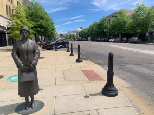
A statue of Rosa Parks at the corner where she boarded her bus in Montgomery, Alabama, on December 1, 1955
What Parks was doing was in violation of city law. Under Montgomery regulations, the first 10 rows of a bus were reserved for white riders. Black riders entered the bus from the rear entrance and sat in the back rows. A white rider and a Black rider could not sit next to each other.
Black riders were also expected to give up their seat in the “colored section” to white passengers if the front rows filled up. Parks was in the front row of that section that day and refused to abide when the bus driver told her to give up her seat.
Parks was not the first Montgomery citizen to challenge these regulations. Three other Black women had been arrested earlier that year for violating the city’s ordinance. Those other three, however, resisted arrest and were charged with that violation.
Parks, who was active in the local civil rights movement, made sure she didn’t resist so she had to be charged with violating the city’s bus rules. That allowed civil rights attorneys to challenge the seating restrictions in court.
It also sparked the Montgomery bus boycott just four days later.
Civil rights activists knew that 75 percent of Montgomery’s bus riders were Black, so if they stopped riding the buses the transit system would be hurt financially.
On the first day of the protest, 40,000 Black riders boycotted the bus system. The boycott lasted until December 20, 1956.
The end came after the U.S. Supreme Court upheld a lower court decision that the bus segregation laws in Montgomery were unconstitutional.
The local regulations were removed, but resistance continued.
In 1957, snipers fired at Montgomery city buses as well as at homes owned by Black residents. Churches were also bombed.
The boycott thrust the Montgomery campaign to end desegregation into the national spotlight. It also helped lift the Reverend Martin Luther King Jr. into a national figure. Shortly after the boycott, King founded the Southern Christian Leadership Conference, an organization that spearheaded civil rights action in the South.
Civil rights actions continued in Montgomery into the next decade.
In February 1960, more than 30 students from Alabama State College held a sit-in protest at the lunch counter at the county courthouse. The owner closed the lunch counter and segregationists assaulted the students. The governor ordered the college to expel any students participating in sit-ins.
A few days later, 800 people attended a speech by King in preparation for the next protest. On March 1, more than 1,000 demonstrators marched from the college to the state Capitol. The college president expelled nine students and suspended 20 others.
A week later, more than 1,000 students voted for a mass strike during spring registration for classes. In the ensuing weeks, more students were arrested and some were blacklisted at other universities.
In 1961, a group of Freedom Riders arrived at the Montgomery bus station and were beaten by members of the Ku Klux Klan. The Freedom Riders were a group of 400 Black and white activists who rode regularly scheduled long distance buses together for seven months in 1961. The riders were testing a 1960 Supreme Court decision that declared segregated facilities on interstate buses illegal.
The 1965 march from Selma that ended in Montgomery put an even brighter spotlight on the city.
In 1971, Morris Dees, an attorney, founded the Southern Poverty Law Center in Montgomery. The organization provided legal assistance to low-income persons and people of color.
Montgomery has a host of historical landmarks that recognize the struggle for equal rights.

The National Memorial for Peace and Justice in Montgomery, Alabama. Photo by Smarthistory.
The National Memorial for Peace and Justice is the newest. It opened in April 2018 with the intent of educating the public on the country’s history of racial injustice. The museum was created by the Equal Justice Initiative. The facility sits on 6 acres. One of its main features is the museum’s recognition of the 4,400 Black citizens who were murdered in lynching incidents between 1877 and 1950 across the country. There are also 805 steel plates the size of coffins representing the counties in the country where a lynching occurred.
The complex also has a wall with heads of African-Americans sticking up their arms in surrender to highlight the treatment of Black citizens by police officers. There is also a section recognizing counties that have dedicated monuments to the lynchings in their region. In addition, there is a glass box filled with soil brought in from various areas of the countries where lynchings took place.
Not too far away is the Civil Rights Memorial Center. The facility is the former offices of the Southern Poverty Law Center. In front is a memorial to the 40 people who died fighting for civil rights from 1951 to 1968. The memorial center, which was dedicated in 1989, was designed by Maya Lin, who created the Vietnam War wall in Washington, D.C.
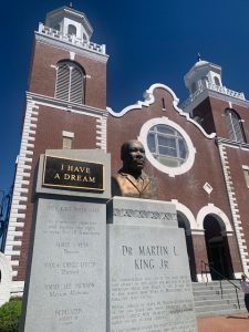
Near the state Capitol is the Dexter Avenue King Memorial Baptist Church, where King preached from 1954 to 1960. The church, which was founded in 1877 in a slave trade pen, was designated as a national historic landmark in 1974. The church basement was where the 1955 bus boycott was organized.
In the downtown region is a plaque at the bus stop where Parks boarded her city bus on December 1, 1955. A few blocks away on Troy University’s Montgomery campus in the Rosa Parks Museum, located on the spot where Parks was arrested. The archives there include Parks’ fingerprint record from her arrest as well as a 1950s era city bus.
Not too far away is the Freedom Rides Museum. The facility is located in the old Greyhound bus station where the riders were beaten in 1961. Mug shots of some of the protesters, both white and Black, are also featured.

The Freedom Riders Museum in downtown Montgomery, Alabama
There are also three historical markers near the city’s waterfront to document the history of the slave trade here. The placards were dedicated in 2013.
One anomaly to all this is the Confederate Memorial Monument, located on the grounds of the state Capitol. The 88-foot-tall monument commemorates the 122,000 Alabama residents who fought for the Confederacy during the Civil War. The memorial was dedicated in 1898. Its days may be numbered, however. In 2015, the governor ordered four Confederate flags removed from the monument. In 2019, a judge ruled that an Alabama law approved in 2017 that protected Confederate statues was unconstitutional.
Today, Montgomery is a community of 194,000 residents, the second most populous city in Alabama.
Its economy is centered on jobs from government, education and the military, in particular the nearby Maxwell Air Force Base.
The city has been recognized for its urban renewal projects. Part of that program was the 2004 construction of minor league baseball stadium for the Montgomery Biscuits. That new ballpark spurred developers to convert old warehouses into loft apartments, restaurants and retail businesses.
So ends a day when we absorbed a big slice of the Deep South. Tomorrow, we’ll digest another chunk as we travel southward again toward the Sunshine State.