
Day 14: A Deep Dive Into the Deep South
April 2, 2021
Day 12: Blowing Through the Bayou
March 31, 2021
Most recently updated on March 13, 2024
Partially driven on April 3, 2023
Originally posted on April 1, 2021
New Orleans is our finale today, but we have an interesting road filled with frogs, Cajun culture, the Mighty Mississippi and world famous sausages before we get there.
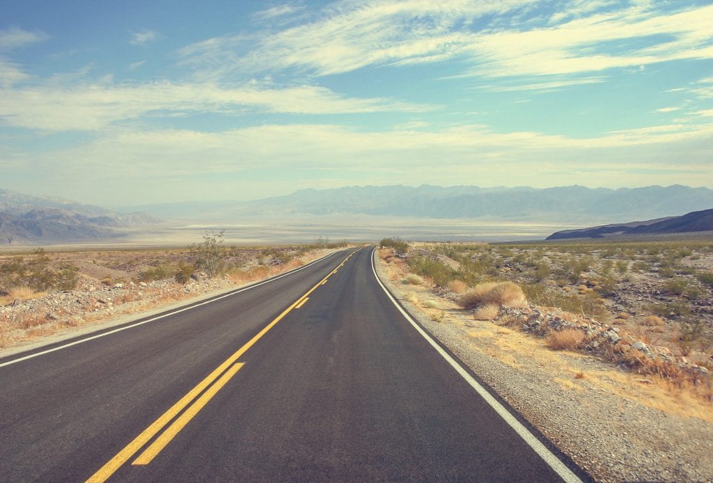
We’ll be on Interstate 10 all day so we head east on that freeway out of Lake Charles.
After an hour of driving through flat, low-lying bayou country, we arrive in the town of Rayne, a community of nearly 7,000 that is literally hopping with history.
Rayne calls itself the “Frog Capital of the World.” And not without reason.
The community got its start as a stagecoach stop along the Old Spanish Trail from Florida to Texas.
 It expanded when the Louisiana Western Railroad arrived in 1880, allowing rice farmers to ship their product to more far-reaching places.
The frog legacy started later that decade when local gourmet chef Donat Pucheu began selling frog legs from the rather large bullfrogs in the nearby swamps to New Orleans restaurants. The Rayne frogs became a hit and enticed Jacques Weil and his brothers to move to Rayne in 1901.
The French siblings began exporting frog legs by train to restaurants across the country. The local delicacy actually got a mention on the menu at Sardi’s in New York City. Some restaurants in France followed suit, praising the Rayne frog legs by name.
The publicity boosted business back in Louisiana. At one point, the Weil brothers were shipping out 10,000 pounds of frog legs per week.
The success continued for decades. In 1937, the Louisiana Frog Company sent a half million local frogs to restaurants all over the world.
Frog legs are no longer exported from Rayne. The biggest industries are retail trade and manufacturing. Rice remains the major agricultural commodity.
The frog culture, though, lives on.
In 1946, the city’s first Frog Derby was held in conjunction with the International Rice Festival in nearby Crowley. During the event, young women dressed up as jockeys and raced frogs.
In 1973, the Rayne Frog Festival was established. It’s now held in May and includes the crowning of the Frog Queen, Junior Frog Queen and, for the kids, a Mr. and Miss Tadpole. The 50th anniversary festivities were held in May 2022.
The frog legacy also shows up in artwork downtown.
In the 1990s, members of the Rayne Beautification Board hired muralist Robert Dafford to decorate blank brick walls with historic murals that feature various frogs. There are 30 of the murals today. The artwork has bestowed Rayne with the official title of “Louisiana City of Murals.”
There are also a number of small frog statues that adorn businesses around town. A large frog statue named “Monsieur Jacques” greets visitors as they enter town.
Rayne is also a place that takes pride in its French heritage. At 10 a.m. on Saturday mornings, locals have gatherings called “Le table francaise” where they speak French and discuss their heritage.
One of those get togethers happens at the Bernard Bertrand House. The other occurs at Frog City Travel Plaza, a place where you can stop for gas and some conversation.
Cajun Country
Did you know the beginnings of Cajun culture are actually rooted in Canada? We didn’t until we started researching the history of Lafayette.
The community of 121,000 people is only 20 minutes east of Rayne. It’s the fifth most populous city in Louisiana and is named after the Marquis de Lafayette, the French military officer who helped the U.S. colonies win the American Revolutionary War. The Marquis should be familiar to fans of the musical “Hamilton.”
Lafayette is considered the center of Cajun culture in Louisiana and it’s certainly a major component of the city’s history.
The region was originally occupied by the Attakapas tribe.
In the 1700s, French settlers set up a trading post along the Vermilion River before French Acadian refugees began arriving later in the century. The Acadians were descendants of people who had immigrated from France in the 1600s to the Canadian maritime provinces.
When the British took over Canada from the French in 1713, they ordered the Catholic worshipping Acadians to convert to the Protestant religion. The Acadians refused and over the next 40 years, the British seized farms and burned villages. In the 1750s, they began sending the Acadians on ships to the United States.
During the next 10 years, the Acadians were turned away in places such as Massachusetts and Pennsylvania. They were finally welcomed by Catholic-leaning Spanish authorities in Louisiana in the 1760s.
The Acadians arrived in Lafayette around 1765. Over the decades, they intermarried with other settlers and eventually created a culture that was dubbed Cajun.
The ethnic group assimilated into Lafayette society. The town then was an agricultural community that relied heavily on sugar cane plantations and enslaved African labor. In fact, the 1830 census showed that 41 percent of Lafayette’s population were slaves.
After the Civil War, many former slaves worked as sharecroppers on farms, essentially trading their labor for room, board and a portion of the crops.
Agriculture has remained a major segment of the economy, although mechanization that began in the 1930s reduced the need for cheap labor.
The discovery of oil in the region in the 1940s turned Lafayette into a supply center for the petroleum industry. The Heymann Oil Center opened in 1953 to serve as a headquarters for several oil companies. The facility also had a lunchroom for visiting executives to use. The building has been open to the public since 1986.
In 1983, Downtown Lafayette Unlimited joined forces with the Downtown Development Authority to help revitalize and preserve the downtown area.
In 1985, the Cajundome opened with Kenny Rogers as the first musical act. Since then, entertainers such as Billy Joel and Cher have performed at the 13,000-seat arena. College basketball is played there, too.
Lafayette remains a shipping center for cotton, sugar, lumber and livestock. It’s also a town that hasn’t forgotten its roots.
The Council for the Development of French in Louisiana (CODOFIL) was formed in 1968 and chose Lafayette as its headquarters. The group’s main purpose is to preserve the French language in the state. It was organized by attorney and former congressman James Domengeaux.
The organization oversaw the expansion of French education in public schools. They also set out to boost pride in Cajun culture as well as battle stereotypes in movies and television.
When the Cajuns arrived here more than 250 years ago, they began harvesting shrimp, crawfish, crabs and oysters from the bayou. They also grew rice, peppers and okra. Over the years, they developed their own style of cooking that includes gumbo and jambalaya as well as their own distinct style of music.
Most Louisiana Cajuns live in a 22-parish region in the southern part of the state that’s informally called Acadiana.
Cajuns are not to be confused with Creole. That is a different and less well-defined group of people with a ancestry mix of African, Caribbean, French and Spanish. Many Creole live in New Orleans, but there is a sizable segment in Lafayette.
The impact of Cajuns on this region is recognized at the Acadian Cultural Center, which details the history, migration and practices of the French descendants.
Lafayette is also the hometown of a young woman who is making a splash in modern day culture.
Addison Rae Easterling was born and raised in Lafayette.
In the past few years, the 23-year-old Easterling has become a TikTok star with her singing and dancing videos. She now has 88 million TikTok followers, the fifth most on that site. Easterling also has a popular Instagram account and YouTube channel.
In March 2021, Easterling became the subject of criticism after her dance performance on The Tonight Show with Jimmy Fallon. People on social media noted her dance moves were patterned after choreography done by Black artists and, they added, it was pretty subpar.
It’s uncertain how much the criticism bothered Easterling. After all, her net worth is listed at $5 million.
In May 2023, it was announced that Easterling will star along with Ryan Reynolds and Aubrey Plaza in the live-action film “Animal Friends.”
Motoring Along The Big Muddy
Once more we’re on Interstate 10, heading east through southern Louisiana.
Just a few minutes outside Lafayette, we cruise past Breaux Bridge, a town of 7,300 people that calls itself the “Crawfish Capital of the World” and specializes in Cajun food and Zydeco music.
Less than a half-hour later we cross the Atchafalaya River, a waterway that flows from the Red River south to the Gulf of Mexico.
However, that scenery is really just a warm-up.
Less than an hour after leaving Lafayette, we see the prime attraction as we cross the Mississippi River to enter Baton Rouge.
The Mississippi is 2,350 miles long, making it the second longest river in North America. The Missouri River, one of the Mississippi’s tributaries is actually 100 miles longer. Later in this trip, we’ll stop at the place where these two mighty waterways converge.

The hard-working Mississippi River. Photo by goodnewsnetwork.org
The Mississippi begins at Lake Itasca in northern Minnesota. It flows through 10 states before it dumps into the Gulf of Mexico just south of New Orleans.
Native American tribes lived as hunter-gatherers along the river for thousands of years. The word “Mississippi” comes from an Algonquian phrase meaning “big water” or “father of waters.”
The first European to see the Mississippi was Spanish explorer Hernando de Soto during his 1541 travels. The French, British and Spanish all laid claims to the river at various times.
For a while, the Mississippi was the western boundary of the United States until it became part of this country in the 1803 Louisiana Purchase.
The land around the river is one of the richest agricultural regions of the country thanks to the fertile silt that is deposited by the waterway.
The river’s location and navigability were a prime impetus for the steamboat era. It’s also why the capture of the river by Union forces was considered a major turning point in the Civil War.
Today, the river provides drinking water for more than 18 million people and supports a $12 billion shipping industry that provides 35,000 jobs. More than 170 million tons of freight per year are moved through the upper Mississippi. Half the nation’s corn and soybean crop is barged along the upper reaches. About 60 percent of the grain exported by U.S. farmers is transported down the river to ports in Louisiana. The lower Mississippi is an important route for petroleum, wood and other industrial products.
The river also supports a $21 billion industry of tourism, fishing and recreation that produces 350,000 jobs.
During the 1900s as cities grew along the Mississippi, there were dams, locks and levees built. More than 2,000 miles of the Mississippi’s watershed has been affected by these barriers.
Environmental problems have ensued.
The organization American Rivers has launched a campaign to restore the Upper Mississippi to its more natural state to restore lost habitat and river function.
The dams and locks now capture most of the 220 million tons of sediment per year that used to be deposited at the Gulf of Mexico. That is causing the delta region to erode and shrink into the sea.
Agricultural pesticide runoff is another problem. Environmentalists say the chemicals are killing fish, encouraging the growth of harmful algae and contaminating drinking water.
They add the runoff has created a “dead zone” in the Gulf of Mexico along the Louisiana coastline. In this zone, the gulf waters are robbed of necessary levels of dissolved oxygen. When that happens, aquatic life either needs to move elsewhere or die. In the past, scientists have estimated the dead zone at almost 6,300 square miles. In August 2022, the estimate had shrunk to 3,200 square miles.
The Mississippi River Collaborative has made the reduction of nitrogen and phosphorous from farms and livestock a priority. One way to achieve that, the group says, is to eliminate the exemption for farm pollutant runoff in the Clean Water Act. They also urge states as well as farmers themselves to take action.
Flooding is another concern. The Mississippi has a long history of overflowing its banks.
Flooding in 1927 submerged 23,000 square miles of land all along the Mississippi. Hundreds of thousands of people were displaced and 250 were killed.
In spring 2019, heavy rains in the Midwest caused serious flooding in Iowa, Illinois and other locations. Hundreds of roads were inundated and at least four people died.
This problem is becoming more acute. A 2018 study reported that the risk of 100-year floods on the Mississippi has increased by 20 percent over the past 500 years.
A Time magazine article in August 2019 detailed the complications of trying to institute flood control measures along the river. Opening one flood gate can send fresh water cascading into the salt water of the Gulf of Mexico. Opening another gate can send water crashing down onto farmland. In 2011, the opening of a flood gate cost the Mississippi economy $58 million, mainly due to a reduced oyster harvest.
Issues such as winter snowpack melt in the Rockies as well as storms that barrel through the Southeast are part of the calculations when deciding whether to open gates to prevent the Mississippi from flowing over its banks.
Part of the problem, engineers told Time, is that the levees built over the decades have narrowed the river. Plus, urban pavement has replaced soil that used to absorb some of the rain runoff.
In October 2023, another issue cropped up along the Mississippi. Not enough water. Officials reported that the drinking water in New Orleans and other cities had a high salt content because drought conditions in the Midwest have reduced the river’s water levels and allowed salt water from the Gulf of Mexico to creep in.
The Mississippi River Cities and Town Initiative (MRCTI) with nearly 100 mayors on board was formed in 2012 to tackle some of the issues involving the watershed.
Since then, the MRCTI has been working toward its goal to “protect and restore the Mississippi River as a natural system that can support human culture and economies, as well as the river’s unique ecosystem and wildlife.”
The issues they contend with range from water pollution to infrastructure to habitat restoration to creating green jobs to climate change.
Sharon Weston Broome, the mayor of Baton Rouge as well as the president of East Baton Rouge Parish, is one of the mayors on the MRCTI.
She says that organization works well together and stays away from partisan politics.
“It’s all about the Mississippi River,” she told 60 Days USA.
At a virtual conference in March 2021, Broome said the group focused on river water quality, conservation, sustaining the economy along the river and reducing pollution.
To that end, Baton Rouge is part of a pilot program that will study the issue of plastic waste polluting the Mississippi. Participants will research where the plastics come from and then apply for grant money to install collection barriers to catch the waste.
In March 2022, MRCTI officials announced a program to help cities along the Mississippi River access federal funding under the infrastructure bill signed by President Joe Biden in November 2021.
In March 2024, a $14 million plan was unveiled to divert some Mississippi River water to help restore the Maurepas Swamp in Louisiana. It’s the first project to divert river water to restore a swamp land.
—————————————–
Interstate 10 takes us across the Mighty Mississippi and into Mayor Broome’s town.
Baton Rouge is the capital of Louisiana and the second most populous city with 216,000 residents.
It sits atop Scott’s Bluff overlooking the Mississippi River and is home to Louisiana State University, known as LSU to college football fans across the country.
Native American tribes began occupying this region 10,000 years ago.
They were still here when Spanish explorers first visited the area in the early 1500s. A French expedition arrived in 1699 and named the region Baton Rouge, which translates into “red stick,” after a red cypress tree that marked the boundary between two tribes.
The area was ruled by the British, Spanish and French until it became part of the United States under the Louisiana Purchase in 1803.
Baton Rouge was selected as state capital in 1849, replacing New Orleans.
Steamboat trade helped the city grow in the 1800s. In the 1900s, the petrochemical industry provided an economic lift, especially during World War Two as well as in the 1950s and 1960s.
In addition to petrochemicals, Baton Rouge’s top industries today also include technology, medical services, research and film. It’s also a distribution center for the surrounding agricultural areas.
The ExxonMobil refinery here is the fifth largest fuel-making plant in the country, pumping out products such as gasoline, diesel and an array of chemical compounds.

The Port of Greater Baton Rouge is the 8th largest port in the United States in terms of tonnage.
A lot of the city’s industry relies on the Port of Greater Baton Rouge. This is the 8th largest port in the nation in terms of tonnage. It’s also the farthest up the Mississippi River that cargo carriers and ocean-going tankers can travel. The products that travel through the port range from sugar to coffee to molasses to grain to asphalt to coal to steel to liquid bulk chemicals. The port completed an expansion in August 2020 that allows it to handle 2,000 shipping containers at one time.
Nonetheless, the city does have its economic problems.
It has an annual median household income of $50,000. Its poverty rate rests at 24 percent. The city population is 53 percent Black and 35 percent white.
Broome says the city economy is built around the port as well as the petrochemical and manufacturing industries. There are also 76,000 government employees in town. She also notes that 80 percent of businesses in Baton Rouge are locally owned.
One other issue Baton Rouge is dealing with is a topic that is a high priority in many cities, especially those with significant Black populations.
Police reform and community policing were one of the issues Broome highlighted when she was first sworn into office in 2017.
A major impetus behind this issue was the 2016 fatal shooting of Alton Sterling, a 37-year-old Black man who was shot by police officers while he was pinned to the ground. The officers were investigating reports of a man selling CDs outside a convenience store and threatening customers with a gun. Neither of the two officers was charged in the case.
A few weeks later, three Baton Rouge area law enforcement officers were ambushed and killed by a former Marine who said he was upset over the Sterling shooting. The gunman was later killed by other officers.
Broome said in spring 2021 that progress has been made in recent years, but there is still a long way to go.
“The relationship between our community and our police department is an ongoing issue,” she told 60 Days USA. “We cannot sit back on our laurels.”
There have been changes made in the rules ranging body cameras and use of force.
In addition, the Safe, Hopeful, Healthy Initiative was launched in fall 2020 using money from the CARES act. The four pillars of the program are community-based public safety, expansion of healthcare and equitable community development as well as stabilizing youth, community and family.
In February 2021, project leaders unveiled the neighborhood engagement hub, which allows residents to connect with resources and leadership training. The programs include neighborhood cleanups and a tool lending program.
“We’re training community leaders and instructing community folks as violence interrupters. We’re going into our school system,” the mayor said.
Despite all its issues, Broome said Baton Rouge is a great place to live.
She moved here from Chicago with her parents as a college student in 1979 and never left.
She said she “fell in love” with the city’s friendly, hospitable people, its diverse culture, its music, its architecture and its mix of Creole, Cajun, French, Spanish and Native American food.
“Baton Rouge is a city that brings a smile to your face,” Broome said.
—————————————-
As we head south out of Baton Rouge on Highway 30, we travel through one of the heavily industrialized regions of southern Louisiana.
The petrochemical industry has provided jobs to the region, but they have also produced environmental concerns.
After World War Two, chemical plants began popping up along this Louisiana river corridor, in particular on former sugar cane fields in predominantly Black neighborhoods.
In recent years, those facilities have started to emerge in higher-income white communities. In fact, a 2019 Environmental Protection Agency report noted that the affluent Ascension Parish just south of Baton Route has greater emissions of toxic chemicals from its smokestacks than any other place in the country. In October 2022, a report by the federal Environmental Protection Agency concluded that Black residents in this area experience higher risks of cancer and that state officials have allowed air pollution to remain high here. However, that investigation was abruptly halted in June 2023, much to the disappointment of local residents.
Some activists, mostly retirees, have banded together to try to improve air quality in this stretch of communities along the southern leg of the Mississippi River known as “Cancer Alley,” a 130-mile-long stretch along the Mississippi River that is dotted with more than 200 industrial facilities.
This section of southern Louisiana has been the focus of a series of reports the past few years by a journalistic partnership between ProPublica, The Times-Picayune and The Advocate. In 2023, researchers at Tulane University also documented what they say are high cancer risks in the region and state officials complicity in creating the problem.
One of those places in the line of fire is St. Gabriel, a town of 6,700 people just west of Ascension Parish.

Petrochemical facilities are a concern among some residents in southern Louisiana. Photo by The Advocate.
It was settled in 1767 by the French Acadians from Canada. For a while, it was along the border between Spanish and English territories.
It’s home to St. Gabriel Catholic Church, which was finished in 1776 and is the oldest church structure in the Mississippi Valley.
Over the past few decades, 30 petrochemical plants have been built within 10 miles of St. Gabriel. They include the world’s largest manufacturer of Styrofoam.
In 1994, this predominately Black community decided to take matters into its own hands.
They voted to incorporate as a town in an attempt to prevent new chemical plants from being built within their borders. They incorporated as a city in 2001.
One of the big recent fights was the 2017 battle to prevent expansion of the Adsorbent Solutions chemical waste recycling plant in St. Gabriel. In April 2017, the City Council denied a zoning request from the company, in essence killing the expansion.
In 2019, the council did approve a $70 million modernization and expansion plan for the Eastman chemical plan in town, a facility city leaders said has been a good neighbor.
In addition to its action on chemical plants, the city during the past 25 years has also added a new sewer system, new street lighting, parks and a $4 million community center.
Despite their efforts, companies still find the region’s cheap land, access to Mississippi River transportation systems and a friendly regulatory process irresistible.
Seven new petrochemical facilities have been approved in this corridor since 2015 and five more are awaiting approval. In September 2022, a federal court did block the air pollution permits for a large plastics factory.
All of these new projects are outside St. Gabriel’s city limits but within breathing distance.
Hazel Schexnayder was one of the original incorporation activists in St. Gabriel. There are 13 petrochemical plants within three miles of her home.
She told Pro Publica in 2019 that she and her neighbors had simply had enough when they decided to organize, saying they missed the nice, clean air they used to have in town.
Broome said there has always been a delicate balance between the community and the petrochemical plants.
The industry has employed local citizens for generations, but it also has been a health concern for those who live close these plants.
“The petrochemical industry has been part of the fabric of this community for generations,” the mayor said. “There has been a level of co-existing, but as the years have passed on there has also been a level of accountability.”
———————————————-
We travel south on Highway 30 out of St. Gabriel and eventually cut back across to Interstate 10.
In less than an hour, we reach the shores of Lake Pontchartrain, a brackish estuary created about 3,000 years ago by the constant movement of the Mississippi River.
Lake Pontchartrain has an average depth of 12 feet. It’s 40 miles long by 25 miles wide, covering 630 square miles.
That makes it the second largest inland salt water body in the United States. Only the Great Salt Lake in Utah is bigger.
Lake Pontchartrain sits on the northern edge of New Orleans and is connected at one end to the Gulf of Mexico. Its waters were one of the sources of flooding in New Orleans after Hurricane Katrina hit in 2005. Its waters were also polluted by the 2010 Deepwater Horizon Oil Spill.
The estuary is crossed by the 23-mile-long Lake Pontchartrain Causeway, two parallel elevated roads that opened in 1956 and form the longest over-water bridge in the world.
The estuary was heavily polluted in the 1960s and 1970s, but the water has been cleaned up since then with the help of bottom-feeding clams. The lake is also the end point for a lot of trash that is tossed into storm drains. In 2019, clean-up crews removed nearly 60,000 pounds of trash from the lake during a one-day “beach sweep.”
Pontchartrain is considered a vital component of the local economy as well as regional recreational activities. It’s also a home for endangered birds, fish and marine animals to raise their young. In addition, it’s on the migratory path for a number of birds. That includes the purple martin, which are an interesting part of history in a town we will visit in the second half of our 60-day journey.
On the lake’s western shores sits LaPlace, a city of almost 28,000 people that rests at 13 feet above sea level. Its low-lying topography was spotlighted in late August 2021 when Hurricane Ida roared through, flooding neighborhoods and damaging property with its harsh winds.
The Chitimacha tribe lived in this region for centuries. The town was settled by German immigrants in the 1720s. It’s part of the so-called German Coast in Louisiana. Its first sugar plantation was built in 1793.
The town was the site of an 1811 revolt when 500 armed slaves set out from LaPlace in an effort to conquer New Orleans. The marchers killed two white men and burned several plantations. Federal troops along with a slave owners’ militia confronted the group and killed nearly 100 slaves during a three-day battle. Another 18 of the protesters were convicted by tribunals and executed. Their heads were placed on poles along the river to intimidate other slaves.
In 1879, Basile Laplace, a pharmacist and planter, established a large plantation in the community and gave permission for the New Orleans and Baton Rouge Railroad to cut through his property. A railroad depot and the town were subsequently named after him.
Today, LaPlace is home to the Port of South Louisiana, the largest port in terms of bulk cargo in the world. It’s also the largest in cargo volume in the Western Hemisphere as well as the largest tonnage port in the United States. In 2022, the port saw its first increase in tonnage since 2017 to a total of nearly 240 million short tons.
The port extends for 54 miles along the Mississippi River Waterway system with LaPlace as its center. Nearly 100 industries are located within its boundaries.
About 4,000 ocean-going vessels and 55,000 barges pull into the port in a normal year. The port handles more than 50 percent of U.S. grain exports and more than 70 percent of U.S. petroleum imports.
The facility is the terminus for the only offshore super port in the United States, a complex located 15 miles off the Louisiana coast that produces 500,000 barrels of crude oil a day. The South Louisiana port is also the origin of a 640-mile pipeline that transports 800 barrels of oil a day to the Midwest.

LaPlace, Louisiana, is known as the place for andouille sausage. Photo by wwno.org.
The port handles nearly $70 billion in trade annually and supports more than 30,000 direct jobs.
All this industry does seem to provide most people in LaPlace an opportunity to earn a decent living. The annual median household income here is $70,000 with a poverty rate of 12 percent.
One product LaPlace is well known for is the pork sausage known as andouille. In 1972, the governor of Louisiana declared LaPlace the “Official Andouille Capital of the World.” The town hosts a regional Andouille Festival in October.
It also has Jacob’s World Famous Andouille, a little restaurant that’s been in the same barn-like structure on West Airline Highway since 1928. You can get all kinds of sausage, including andouille, as well as smoked chicken.
A Drive Down Memory Lane
It’s a half-hour trip down Interstate 10 from LaPlace to New Orleans, a city with no shortage of history or culture.
This region was first inhabited by the Woodland and Mississippi tribes.
The city was founded in 1718 by French colonists. It became part of the United States under the 1803 Louisiana Purchase.
It was the site of the Battle of New Orleans in January 1815, when General Andrew Jackson’s troops defeated a force of 8,000 British soldiers in what was the final battle of the War of 1812.
New Orleans has always been an important port. In the 1800s, the docks shipped goods to South America, the Caribbean and Europe. It was also a major center for the southern slave trade due to the sugar and cotton plantations in the region.
At one point, New Orleans was third most populous city in the country as well as the wealthiest.
Over the decades, New Orleans earned the nickname “The Big Easy,” perhaps because of its laid back lifestyle or how easy it was for musicians to find work here. It’s also called the “Crescent City” due to the shape of the Mississippi River as it cuts through town.
There is so much to see here, but before we drop down into the city, there is a nearby place on which I need to check.
We cut through the middle of New Orleans on I-10, passing the Caesars Superdome, formerly known as the Mercedes-Benz Superdome, as we reach the eastern edge of town.
The sports arena opened as the Louisiana Superdome in 1975. It sits on a 52-acre lot and is clearly visible from the freeway. It’s 680 feet in diameter, making it the largest fixed-dome structure in the world. It’s 273 feet at its highest point and has a maximum seating capacity of nearly 74,000. A $450 million renovation of the Superdome began in 2019.
The arena is the host field for the Sugar Bowl and home turf of the New Orleans Saints football team. It has also been the site of seven Super Bowls, more than any other single facility. It will host the Super Bowl again in 2025.
At the Superdome locale, Interstate 10 takes a sharp break to the east. We’ll be on this part of the freeway a little later on our virtual tour.
For now, we continue straight ahead on Business 90, also known as the Pontchartrain Expressway.
We zip past the famous French Quarter and cross the Mississippi River into the enclave of Algiers.
I lived in this community for a little more than 3 years from spring 1960 to summer 1963 when my father was in the Navy and we were stationed here.
Algiers was first settled in 1719 and annexed by New Orleans in 1870, so it’s officially one of the city’s neighborhoods.

The Harriet Tubman Charter School in Algiers, Louisiana. I went to classes here in the early 1960s when it was known as Adolph Meyer School. Photo by EnrollNOLA.
One of the first exits after crossing the Mississippi is General De Gaulle Drive. How’s that for a French connection? It doesn’t take long to reach Lauradale Drive, the street I lived on with my family. In April 2023, we cruised through the neighborhood, where my house still stands. The house next door where an older woman who didn’t seem to like children lived has been torn down. My home looked pretty much as it did in the early 1960s except the carport has been converted into an extra room.
The next stop was the former site of Adolph Meyer School, which I attended for the final few weeks of kindergarten as well as first, second and third grade. The school was less than a mile from our home and my older brother and I used to walk there.
The two-story school was built in 1917, occupying an entire block on General Meyer Avenue.
When I attended, Adolph Meyer was a segregated school even though the Black neighborhood was closer to the campus than my neighborhood.
The school is now the Harriet Tubman Charter School, a campus for 3rd through 8th grade students. It’s also now on the National Register of Historic Places under its original name of Adolph Meyer School. During our visit in April 2023, I was pleased to see the school had a fresh coat of paint and looked much the same as it did six decades ago.
—————————————-
There’s another elementary school in New Orleans that made some history while I was attending Adolph Meyer.
So, we return to Business 90, drive back over the Mississippi River to Interstate 10 and take that eastbound section of roadway.
In a few minutes, we exit into the South 7th Ward and drive through the St. Claude district.
We finally end up at the site of William Frantz Elementary School.
As the crow flies, the campus, which is now the Akili Academy, isn’t all that far from my old school on the other side of the Mississippi River.
But in fall 1960, it was a completely different world from my first grade classroom.
On November 14, 1960, a first grader named Ruby Bridges became the first African-American child to attend an all-white elementary school in the South.
The 6-year-old girl had attended a segregated kindergarten the year before, but a federal judge in 1960 ordered schools to integrate. Ruby was one of six students who passed an exam the school district had set up purportedly to see if Black children could compete academically in an all-white school.
Ruby and her mother were escorted by four federal marshals into William Frantz Elementary every day that school year. They walked past crowds of protesters who yelled racial slurs. One even displayed a Black baby doll in a coffin.
A number of white parents took their children out of the school. Only one teacher, Barbara Henry, a white instructor from Boston, would allow Ruby in her classroom. No other pupils were allowed to attend, so Ruby was Henry’s only student that entire year.
The William Frantz classroom wasn’t the only place in New Orleans where the battle for civil rights raged.
In September 1960, African-Americans started holding sit-ins at lunch counters that refused to serve Black customers.
The first protest was at a Woolworth’s department store on Canal Street. The second was at the McCrory’s five-and-dime a few blocks away.
In other cities, the lunch counter sit-ins forced the end of segregation in a matter of weeks or months. We’ll visit the site of the first such protest later in the trip.
However, In New Orleans, stores and restaurants continued their segregated defiance despite protesters showing up on Canal Street for two years.
In 1963, the McCrory’s demonstration ended up in the U.S. Supreme Court. The justices tossed out the arrests of four Black protesters in a case known as Lombardi vs. Louisiana.
I can attest to the segregated ways of New Orleans six decades ago. When my family went into New Orleans to visit, I saw signs on water fountains as well as hamburger stands that said “Whites Only.”
That was in addition to the “N word” being dropped in casual conservation by adults and children in Algiers. My mother forbade the word to be spoken at our house. I can remember her calmly telling one of my classmates who was visiting one day and uttering the slur in a nursery rhyme that we didn’t use that word at this house.
Ruby Bridges’ family paid a price for their bravery. Her father lost his job. Grocery stores refused to sell to her mother. Her sharecropping grandparents were evicted from their nearby farm.
Ruby persevered, graduating from a desegregated high school. She became a travel agent, married and had four sons. She and Henry reunited in the 1990s and did speaking engagements together.
In 1999, she established the Ruby Bridges Foundation to promote tolerance and create change on issues of race.
A statue of Ruby Bridges and a plaque about her first day of class were dedicated in 2014 at the Akili Academy.
————————————————–
Right next to the St. Claude district is the city’s Ninth Ward.
This neighborhood was one of the hardest hit when Hurricane Katrina roared through in August 2005.
I remember the approach of Katrina quite well.
At the time, I was producer of the Saturday and Sunday morning newscasts at KPIX-TV, the CBS affiliate in San Francisco. After my Sunday morning newscast on August 28, I went home and told my wife, Mary, about the path and strength of this powerful hurricane.
It was clear from the news reports that morning that Katrina was headed straight for New Orleans. The evacuations efforts were haphazard and there was no federal mobilization.
“This is going to be an unmitigated disaster,” I told Mary.
Unfortunately, I was right.
New Orleans was a sitting duck for this hurricane.
Although half the city is above sea level, the average elevation is 6 feet below sea level.
The city is surrounded by rivers and lakes, so during the 1900s the U.S. Army Corps of Engineers built a system of levees and seawalls to help prevent flooding.
The levees along the Mississippi River were considered strong and sturdy. The levees along Lake Pontchartrain and Lake Borgne as well as the various swamps and marshes… not so much.
Before Katrina arrived, about 80 percent of New Orleans’ residents had left town. However, there were tens of thousands who either didn’t want to leave or couldn’t because of mobility or transportation issues. About one-fifth of the city’s residents, in fact, didn’t have access to a car.
Nearly 10,000 of those who couldn’t leave sought refuge in the Superdome. Others hunkered down at home.
As Katrina slammed into the Gulf Coast with winds of 120 miles per hour on that Monday morning, the levees around New Orleans couldn’t handle the storm’s 10 inches of rain nor its surge. Water lapped over the top of some barriers and several of the levees simply collapsed, allowing water to pour in.
By that afternoon, 20 percent of the city was under water. By the next day, 80 percent of the community was submerged.
Over the next week, the Coast Guard and other agencies evacuated 34,000 people from the flooded city. On September 6, local police estimated there were only 10,000 people left in New Orleans.
It wasn’t until October 11 that the U.S. Army Corps of Engineers pumped the last of the Katrina floodwaters out of the city.
When it was finally over, Katrina had killed a total of 1,833 people, 1,577 of them in Louisiana. It also had caused an estimated $160 billion in damage.
Since then, the Army Corps of Engineers has built a $14 billion network of levees and floodwalls around New Orleans. However, a 2019 report stated that due to rising sea levels, improvements need to be made in the levee system as early as 2023.
The effect the hurricane had on New Orleans’ population is still being felt today.
In 2000, there were 484,000 people living in the Big Easy. In July 2006, there were an estimated 230,000 residents, a decrease of more than 50 percent. The city has rebounded over the past decade, but its population remains under 400,000. It’s still the most populous city in Louisiana, but it’s ranked 53rd in the country, behind Arlington, Texas, and Wichita, Kansas.
The Ninth Ward was Ground Zero for Katrina’s swath of destruction.

The Ninth Ward in New Orleans was the hardest hit region by the floodwaters from Hurricane Katrina in August 2005. Photo by IBTimes UK.
This predominantly African-American neighborhood is bordered by the Mississippi River on the south, Lake Pontchartrain on the north and Lake Borgne on the east. There’s also an industrial canal sprouting from Lake Pontchartrain that runs through the district, separating the Lower Ninth Ward from the rest of the neighborhood.
When the hurricane roared through, the walls of the canal as well as other barriers failed, sending water gushing into the district, in particular into the Lower Ninth Ward.
Most of the news videos that showed people on rooftops waving their arms in desperation were taken from above the Lower Ninth Ward.
Water up to 12 feet deep stood along these streets for weeks. The Lower Ninth was the last neighborhood to have water service and power restored. It was also the last section of New Orleans to be pumped dry.
Like the city, this ward of lower income residents hasn’t fully recovered either.
The population stands at less than 5,000, about a third of what it was before Katrina. There are an estimated 1,675 households, about a third of the 4,820 that were there before the hurricane.
New Orleans suffered another blow in late August 2021 when Hurricane Ida roared through, knocking out electricity to the entire city as well as damaging property in every neighborhood. Initially, 1 million people in Louisiana were without power. Electricity began to be restored three days after Ida hit.
One of the homes that remain in the Ninth Ward is the house where legendary musician Antoine “Fats” Domino lived for almost five decades. Domino was born in the Lower Ninth Ward in 1928, the youngest of eight children.
He rose to fame in the 1950s with hits such as “Blueberry Hill,” “Ain’t That a Shame” and “I’m Walking to New Orleans.” Between 1956 and 1963, he sold more records than any musician except Elvis Presley.
Domino could have lived anywhere, but he chose to reside in the New Orleans neighborhood where he grew up.
He moved into this two-home compound on Caffin Avenue in 1960. He was known to entertain friends, neighbors and relatives from the piano in his front room while pots of red beans and rice simmered in the kitchen.
Domino was rescued by the Coast Guard during the Katrina flooding and his home was seriously damaged. Afterward, he moved into a house in another neighborhood and lived there until he died in 2017.
Fats Domino is just one on a long list of famous musicians from New Orleans.
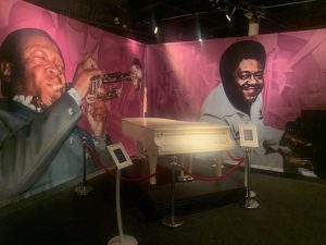
Fats Domino’s piano at the New Orleans Jazz Museum
The best known may be Louis Armstrong, who was born in 1901 in a New Orleans neighborhood so poor it was known as “The Battlefield.” Armstrong, nicknamed “Satchmo,” was a talented blues musician best known for his trumpet playing and his unique singing voice. Among his many hits were “Hello, Dolly” and “What a Wonderful World.” The airport here is named the Louis Armstrong New Orleans International Airport.
Pete Fountain was New Orleans through and through. He was born in the city in 1930 and died there in 2016. He played traditional Dixieland jazz on his clarinet. He learned the craft playing in bars along Bourbon Street. He was a staple at local clubs such as the French Quarter Inn and Pete’s Place. Fountain and his marching band, the Half-Fast Walking Club, were part of the Mardi Gras parade almost every year for decades.
Harry Connick Jr. is also a New Orleans native. He was born in the Big Easy in 1967 and learned music at the New Orleans Center for Creative Arts. Connick is known for his Big Band style music as well as romantic ballads. In 2007, he recorded two tributes to his hometown, “Oh, My Nola” and “Chanson du Vieux Carre.”
Dr. John and New Orleans are almost synonymous with each other. Born in New Orleans as Malcolm John Rebennack, Dr. John was a singer, pianist and songwriter who closely identified with The Crescent City’s musical roots. He even dabbled in the city’s mysterious voodoo culture. After Katrina hit in 2005, Dr. John released the fundraising record, “Sippiana Hericane.” He followed that in 2008 with “City That Care Forgot” about his hometown. When Dr. John died at age 77 in 2019, words of praise flowed from his native town.
Jon Batiste is from a long lineage of Louisiana musicians. Born in nearby Kenner, Batiste grew up in a musical family and also studied at the New Orleans Center for Creative Arts. His 2005 debut album was titled, “Time in New Orleans.” His band, Stay Human, was the house band for “The Late Show With Stephen Colbert.” In April 2022, Batiste won five Grammys for his latest album as well as his work on the soundtrack for the movie “Soul.”
The music scene in New Orleans began with Native American tribes. It was enhanced by the songs sung by African-American slaves and further influenced by immigrants who came to the city.
New Orleans is known as the birthplace of jazz. There are even “jazz funerals” that feature music to help ease the sorrow of the death of a prominent community member.
Gospel music is also part of the history as are the city’s colorful marching bands. Street musicians known as “buskers” perform along popular thoroughfares such as Bourbon Street and Royal Street.
The city’s musical culture is preserved at the New Orleans Jazz Museum along the French Quarter waterfront. Among the displays are a special gallery featuring Fats Domino as well as a wing called Drumsville dedicated to the percussion instruments that made jazz famous here.
—————————————
We also wanted to add some visual beauty to today’s virtual jaunt, so we backtrack to Interstate 10, zoom past the Superdome and drop down into New Orleans’ Garden District.
This neighborhood was first laid out in 1833 by wealthy residents who bought up plantation land so they could live outside the French Quarter. At first, there were only two houses per block with each home surrounded by a lush garden. In the late 1800s some of the larger lots were subdivided, although the architecture and landscaping remained classy.
The district still has oak-shaded streets lined by single-story cottages and grand historic mansions.
It also includes Lafayette Cemetery No. 1, one of the city’s infamous burial sites with tombs built above ground to avoid floating caskets during floods. There are 42 cemeteries in New Orleans, spawning the nickname “Cities of the Dead.”
We stay with the living as we slowly drive past the gardens on St. Charles Avenue.

The George Washington Cable Home in the Garden District of New Orleans
Eventually, we reach the George Washington Cable House, built in 1874 by the well-known author who was a close friend of Mark Twain.
From there, we head to another entertaining place that will bring back memories from my childhood.
We cut through more of the Garden District, eventually reaching Tchoupitoulas Street that takes us along the Mississippi River to Mardi Gras World.
For three straight Februarys when I was child, I attended the daytime festivities for Mardi Gras in New Orleans. The thing I remember most is a parade of floats where the costumed riders tossed strands of colored beads that all the youngsters scrambled to scoop up.
The 300,000-square-foot facility, which opened in 1984, is the place where Mardi Gras floats are worked on before the annual celebration. It’s the largest float design complex in the world.
It’s not just Fat Tuesday festivities that magically get put together here. They create items for 40 parades every year. There are one-hour tours that begin every half-hour.
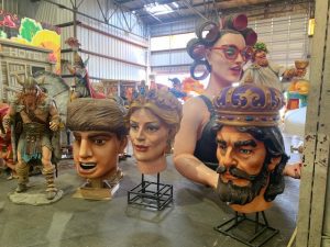
Some of the pieces of floats at Mardi Gras World in New Orleans
During our visit to the facility in April 2023, we saw the handiwork first-hand. An introductory film provided some history of Mardi Gras and explained how the festive season is called Carnival and the Tuesday before Ash Wednesday is known as Mardi Gras.
The complex is not a museum. That’s in another part of New Orleans. Mardi Gras World is a basically an artists studio where people are working year-round to create floats. The artists carefully carve figures from Styrofoam and then wrap them in Plaster of Paris. From there, they are intricately painted. From the walking tour, you see how big and how colorful these parade pieces are.
Near Mardi Gras World is a hidden lunch gem. Central City BBQ sits almost underneath the Business 90 freeway that took us to Algiers. It has little signage outside and almost looks as if it’s closed. However, inside is a different story. During an April 2023 visit, we saw a nearly full house for lunch with a mix of downtown business folks, construction workers and emergence medical technicians. You have to like meat if you eat here because that dominates the menu.
It’s finally time to head to the French Quarter. Fortunately, it’s right next door.
So, we cross under Business 90 and make our way to Burgundy Street, then Canal Street, then Bourbon Street.
The French Quarter is the oldest section of New Orleans. It was founded in 1718. The site was selected for its relatively high elevation of 7 feet amid the region’s lowlands as well as its access to Lake Pontchartrain via a bayou.
The city of New Orleans in essence grew up around the French Quarter. The district flourished in the late 1700s from Mississippi River trade. It was also the only port at the time accessible to people who lived west of the Appalachian Mountains.
For its first 70 years, the French Quarter was all that existed in New Orleans. Eventually, surrounding plantation lands were subdivided and the city annexed them.
Hotels began being built in the early 1800s and tourism has been a staple of New Orleans ever since.
The 13-block by 9-block neighborhood is bordered on the southeast by the Mississippi River and on the southwest by Canal Street.
The entire district was dedicated as a national historic landmark in 1965.
One option for lodging is the Andrew Jackson Hotel, a facility that is listed on the National Register of Historic Places.
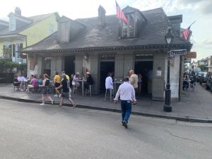
Lafitte’s Blacksmith Shop Bar in the French Quarter of New Orleans
Near the hotel is the Lafitte’s Blacksmith Shop Bar. It’s reportedly the oldest structure used as a bar in the United States, having been built between 1722 and 1732. The facility is reputed to have been used by Jean Lafitte and his brother, Pierre, as a New Orleans base for the smuggling operation.
The New Orleans Historic Voodoo Museum, which opened in 1972, is also close by. It’s only two rooms crammed with artifacts, but it’s one of the museums in the world dedicated to the craft of voodoo, which museum operators say has been a rich part of New Orleans culture since the 1700s.
The museum is emblematic of the multi-cultural nature of New Orleans you can see it as you walk through the French Quarter.
We eventually wind our way to The Riverboat City of New Orleans, a paddleboat resting along the Mississippi River. The Riverboat City began operations in January 2019. It offers two-hour lunch and dinner cruises down the Mississippi.
Just a couple blocks away is Antoine’s, the oldest restaurant in New Orleans. It’s also the country’s oldest family-run restaurant.
The dining established was started in 1840 by Antoine Alciatore. It’s been in the family ever since. Today, it is managed by Alciatore’s great-great-grandson, Rick Blount.
Another well-known restaurant in the French Quarter is Brennan’s, an upscale eatery with a Creole-based menu that has been operating since 1946. Customers are allowed to feed the pet turtles in the restaurant’s courtyard fountain. There is even an annual parade outside Brennan’s where the pets are officially pardoned and saved from the restaurant’s pot where turtle soup is made.
A restaurant in another part of town is mixing food with books. Melba’s is an establishment in the Ninth Ward that specializes in Poboy sandwiches. It was built from the rubble of Hurricane Katrina. For the past few years, Melba’s has sponsored a literacy program in what they describe as their neighborhood’s “book desert.” Among other activities, there is a weekly book signing where free books are handed out. In addition, children who bring in a report card with an “A” get a free piece of cake and their parent gets a free Poboy sandwich. So far, the restaurant has given away 20,000 books.
This seems like an ideal spot to take it easy and call the Day 13 journey to an end.
Tomorrow, we follow the Gulf Coast before heading inland to a state capital that played a major role in this country’s civil rights history.