
Immigration Has Always Been an Issue
July 9, 2020
How Did Nine States End Up With Panhandles?
June 16, 2020
In a country as big as the United States, there are bound to be abnormalities in geography.
Indeed, there are plenty and they all have explanations.
Many have emerged due to economics and political power.
Here’s a glimpse at some of them.
————————————-
If you look at a map and follow New Mexico’s eastern boundary closely, you’ll see it jumps 2.3 miles to the right when it hits Oklahoma. The boundary then heads north in a straight line the rest of the way along the Oklahoma panhandle.
Why is New Mexico’s border with Oklahoma 2.3 miles farther east than New Mexico’s border with Texas? The simple answer is that the man who did the 1859 survey for New Mexico’s eastern boundary goofed up.
Some of his measurements were taken from the south headed north. Another part was taken from the north headed south. The border was supposed to be along the 103rd meridian. The section with Oklahoma was along that line. The section with Texas wasn’t.
—————————————-

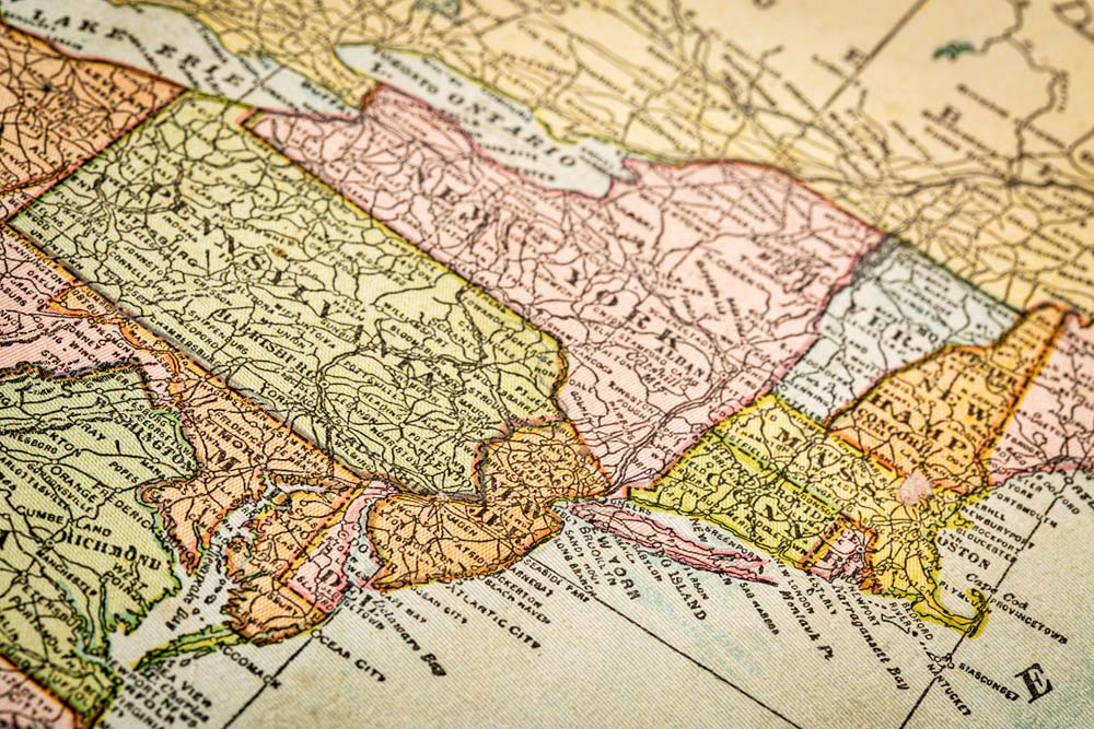
Massachusetts has a small odd piece of land known as the Granby Notch
There’s also a protrusion along Massachusetts’ southern border with Connecticut. It’s called the Granby Notch or the Southwick Jog, among other names.
The story of this little rectangular oddity begins with a survey of lands in 1642 for Connecticut and Massachusetts. Connecticut officials disputed the survey, saying the southern line was eight miles too far south.
Over the next 60 years, each state hired surveyors to establish a border that gave them what they wanted.
In 1724, four towns near the boundary applied for admission to Connecticut because they didn’t like Massachusetts’ higher taxes. Massachusetts refused to give up the towns, but in 1749 Connecticut voted to acquire them.
In 1797, a boundary commission awarded Massachusetts a 2.5-mile square of land to compensate for the loss of those four towns.
In 1804, the two states finally agreed to a compromise that gave Massachusetts 5/8ths of the disputed parcel of land, the area now commonly called “The Notch.”
Some folks in Connecticut still aren’t over it. You can even buy “Take Back the Notch” merchandise.
———————————————-
The Delmarva Peninsula is a stretch of land 183 miles in length and 71 miles in width along the Atlantic coast.
It’s bordered by Chesapeake Bay on the west and the Atlantic Ocean on the east.
The name comes from the fact that three states own pieces of it – Delaware, Maryland, and Virginia.
Why did three states feel the need to plant a stake on this land?
For starters, the peninsula has more than 2,400 miles of coastline along Chesapeake Bay, Delaware Bay and the Atlantic Ocean. That’s a lot of fishing and easy boat access. Much of the 6,000 square miles of land is also fertile for agriculture.
The explorer John Smith checked out the region in 1608 on behalf of the Virginia Colony.
In 1631, the colony of Maryland was given rights to some of the land. In 1681, William Penn was awarded some of the northern property in what is now Delaware.
There were disagreements over the decades over which colony owned what on the peninsula. The border between Maryland and Delaware was established in 1767.
The residents of the peninsula have tried numerous times to become a separate state, including attempts in 1833, 1835, 1852 and 1998.
The folks who live here like to think of themselves as an unofficial independent state. They even refer to the other residents of Delaware, Maryland and Virginia as “mainlanders.”
The three states don’t seem inclined to let their peninsula towns get away. All three market the beaches and recreational activities on their share of Delmarva to tourists.
———————————————-
The northern tip of Delaware has a shape that no other state has. It’s actually rounded at the top.
The arc is known as the Twelve-Mile Circle and its roots go back to 1682.
That’s when the Duke of York awarded Delaware to William Penn, who already had control of the adjacent state of Pennsylvania.
The duke decided the new colony’s territory should be an arc with a 12-mile radius drawn from the courthouse in the town of New Castle on the Delaware River.
Delaware’s border with Pennsylvania follows the arc. However, when the border reaches Maryland’s eastern boundary, it juts out for less than a mile to meet Maryland’s straight line. The little parcel of property north of the intersection that sits in Pennsylvania is known to locals as “The Wedge.”
—————————————-
Pennsylvania has a triangular-shaped piece of land in its northwest corner that gives it access to Lake Erie
Pennsylvania has another geographical quirk on the opposite end of the state.
This is a triangle in Pennsylvania’s northwest corner that sticks up between Ohio and New York.
It’s called the Erie Triangle, although it’s also commonly referred to as the Pennsylvania Chimney.
There’s a simple reason for this odd addition to The Keystone State. Pennsylvania wanted access to Lake Erie.
So did a lot of other people in the 1700s. Five states made claims that their colonial charters granted them rights to the southern shore of Lake Erie.
The colonists weren’t the only ones.
Native American tribes also desired this particular 300-square-mile triangle of land known for its fertile hunting grounds and prime access to the lake. They fought French and British settlers over the territory.
The federal government oversaw the land until 1792 when Pennsylvania purchased 202,187 acres for slightly more than $150,000. Pennsylvania also paid the Six Nations tribes $5,000 for their property.
—————————————-
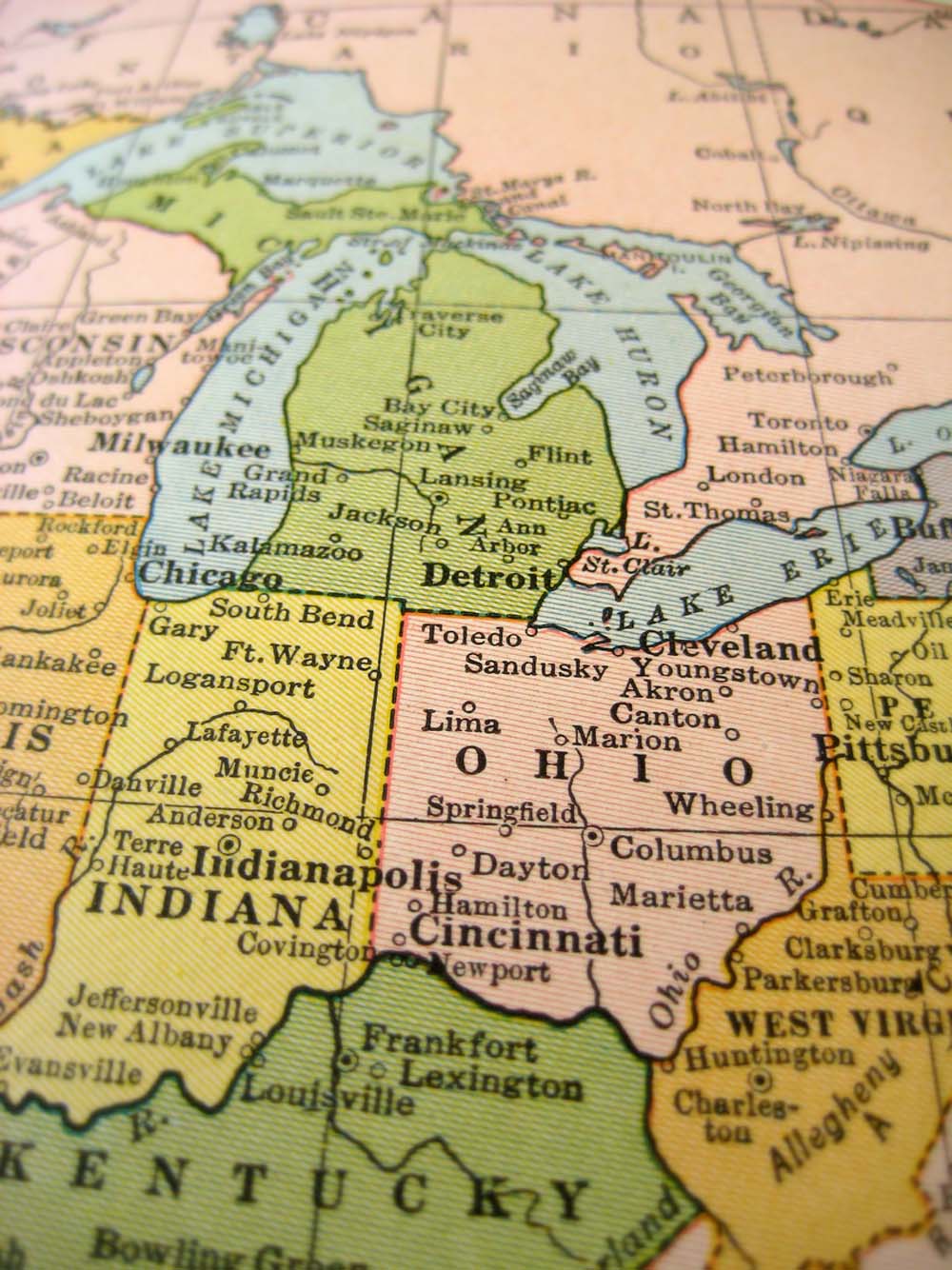
Michigan got its Upper Peninsula in exchange for letting Ohio have the Toledo Strip
Lake Erie is the reason behind another anomaly of the U.S. government.
That being the Upper Peninsula of Michigan.
That large pocket of land clearly should be part of Wisconsin, right? How did Michigan snatch it?
It started in 1835 when Michigan applied for statehood and tried to lay claim to a strip of land near Toledo. Ohio wasn’t having it. They needed that land for access to Lake Erie.
To make a long story short, Ohio eventually was granted the Toledo Strip and Congress gave Michigan the Upper Peninsula in return.
—————————————–
Minnesota also has its quirky piece of property.
The Northwest Angle sticks up like a tiny domino out of the north-central region of Minnesota. It’s surrounded on three sides by Canada and is the northernmost region in the continental United States.
How did that happen? Well, it was a mistake.
As part of the 1783 Treaty of Paris ending the Revolutionary War, this part of the map between the United States and the Great Britain territory of Canada was incorrectly drawn.
The boundary between the two nations was supposed to slice through the Lake of the Woods at a northwest angle, hence the name. Problem was, the map of the lake was wrong and so the United States ended up with a patch of land that really should be part of Canada.
—————————————–
The southwest corner of Alabama is known as that state’s “foot.”
The origins of this rectangle began in 1719 when the French who controlled Mobile Bay and the Spanish who oversaw what is now the Florida panhandle agreed to make the Perdido River between Mobile and Pensacola the border between their territories.
When U.S. officials signed the Louisiana Purchase in 1803, they invoked the 1719 agreement to snag this corner of land as part of what would become Alabama.
When the United States acquired the Florida territory from Spain in 1819, the boundary between Alabama and Florida remained the same.
—————————————–
Missouri has a similar addition. They call it the Missouri Bootheel.
It sticks out of the southeastern corner of Missouri and into the northeastern quadrant of Arkansas.
The credit for the bootheel apparently goes to John Hardeman Walker, an influential landowner in southeastern Missouri.
In 1818, officials in the Missouri territory petitioned Congress to form a new state. The southern boundary was scheduled to be set at the latitude 36 degrees 30 minutes as part of the Missouri Compromise.
Walker and his fellow ranchers realized this straight line would put their properties 25 miles south of the Missouri border and under the jurisdiction of the Arkansas territorial government.
He convinced Missouri officials to request some additions to the statehood proposal that would have made The Show-Me State a lot larger.
Congress rejected most of the additions, but it did allow for the 980-square-mile extension now known as the Missouri Bootheel.
The region encompasses three counties. It was known in the past as a farming area that produced wheat and cotton.
The folks in Arkansas don’t seem overly bitter about the land grab, but they will tell you that the Bootheel has a lot more in common with their state than it does with Missouri.
——————————————
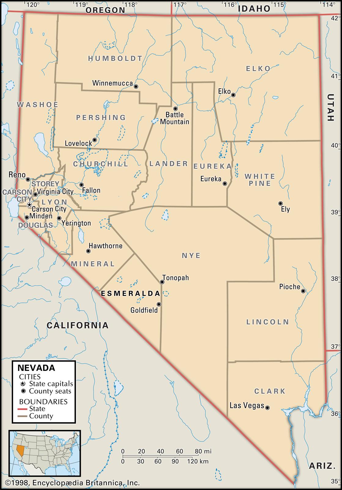
Nevada is the only state that comes to a sharp point at one end.
It’s on the state’s southern edge where it squeezes between California and Nevada.
The east side of the point is formed by the Colorado River, a natural boundary.
The west side is a diagonal that California set up. It runs from Lake Tahoe to the Colorado River.
Simple enough.
Except Arizona had its eye on this land for a long time. In fact, Nevada’s original southern boundary was at the 37th parallel about 60 miles north of where Las Vegas now stands.
In 1867, officials in both Arizona and Nevada made their case before Congress for this tip of land that was at that time still part of the Arizona Territory.
Congressional officials felt Nevada was better equipped to handle the expected population boom after gold was discovered in the region.
Plus, there was one other little matter.
Arizona had supported the Confederacy during the Civil War and Congress wasn’t in the mood just two years after the conflict to do them any favors.
——————————————-
Sometimes it’s not politics but nature that causes odd geographic pockets.
There’s Carter Lake, Iowa. It used to sit with the rest of Iowa east of the Missouri River.
However, a flood in 1877 changed the flow of the Missouri, placing the town west of the river and surrounded by Nebraska.
The community just north of Omaha remains the only location in Iowa west of the Missouri.
—————————————–
Similarly, there’s also the Kentucky Bend, a tiny thumb of the Bluegrass State that’s separate from its homeland.
It’s surrounded by Missouri on the north, east and west as well as by Tennessee on its south.
There are a number of different stories about how this region now populated by only a couple dozen people ended up where it is. They range from territorial disputes to misdrawn maps. One theory even states that an 1812 earthquake shifted the course of the Mississippi River, isolating the tract of land.
————————————————–

The Four Corners Monument is the only place in the United States where four states come together at one point.
The Four Corners intersection might seem like perfect geography.
It’s the longitude and latitude lines where Utah, Arizona, New Mexico and Colorado come together.
It’s the only place in the United States where four states meet.
Officially, the spot is at 37 degrees north latitude and 109 degrees 3 minutes west longitude.
But this basic quadruple border didn’t come without arguments and even legal battles.
The Four Corners region was part of Mexico until it was ceded to the United States in 1848.
The territory of Colorado was established by Congress in 1861. The Arizona Territory was created from the western portion of the New Mexico territory in 1863.
After the Civil War, federal officials decided to officially split the Arizona and New Mexico territories by continuing the north-south Utah-Colorado border in a straight line all the way to Mexico.
In 1868, Congress ordered surveys to establish Colorado as a state as well as find a point where all four territories could come together.
However, surveying equipment in the 1800s wasn’t as good as it is today. Nonetheless, surveyors eventually marked where they could best surmise the exact location of the four territories’ intersection.
The Four Corners monument marker was erected in 1912. It consists of a simple cement pad with a bronze disk with each of the four states’ names.
There have been disputes during the past 109 years. In 1925, a court case was filed between New Mexico and Colorado over the border, but the Supreme Court ruled the boundaries should remain the same. In 2009, the boundary controversy reached Congress after reports revealed that the Four Corners marker is actually 1,807 feet west of where it should be. However, the U.S. National Geodetic Survey, the Supreme Court and Navajo tribe leaders agreed the boundaries should remain where they are.
The area surrounding the monument is Native American land. It is remote. There is a small community with a gas station six miles away, but the nearest towns with hotels and restaurants are more than 30 miles away.