
Day 4: Atoms, Arts and Aliens
March 23, 2021
Day 2: A Grand Tour of Northern Arizona
March 21, 2021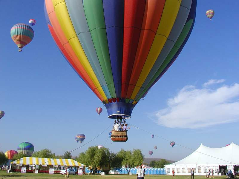
Most recently updated on March 3, 2024
Driven on March 21, 2022
Originally posted on March 22, 2021
We’d love to linger a bit longer in Flagstaff, but we have a day of wide open spaces as well as cultural and natural wonders ahead of us.
So, it’s back onto Interstate 40 east.
In less than an hour, we reach what is described as the best preserved meteor crater on the planet.
The Barringer Meteor Crater is 6 miles south of I-40 in the dry high terrain of this portion of eastern Arizona.
This gigantic hole in the ground is one of 150 identified craters on Earth. But it might be the most impressive.
It’s 3,900 feet in diameter with a circumference of 2.4 miles. It’s 570 feet deep with a rim that is 148 feet above the ground around it.
Like the Grand Canyon, you have to see it to believe it.
The crater was formed 50,000 years ago when this region was open grassland inhabited by mammoths and giant ground sloths.
Scientists believe a 300,000 ton nickel iron meteorite that was 150 feet wide slammed into the ground at 26,000 miles per hour and then vaporized on impact.

The Barringer Meteor Crater in eastern Arizona
The dry Arizona climate has kept the crater pretty much intact over the centuries.
It was discovered by settlers in the 1800s. At first, it was believed the crater was formed by volcanic activity.
In 1903, however, Daniel Barringer, a mining engineer, suggested the crater was created by a meteor. His firm, Standard Iron Company, staked a mining claim to the land. Berringer spent the rest of his life examining the crater.
He never did find the iron ore he was looking for, but in 1960 researchers confirmed his theory.
His family’s business, the Barringer Crater Company, still owns the land. The fact the property is in private hands is why the crater is a national natural landmark but not a national monument.
The site does contain an American Astronaut Wall of Fame at its visitors’ center. The facility has an Apollo astronaut command module as well as 1,400-pound chunk of meteorite found in the area.
About 270,000 people visit the crater in a typical year. We stopped by in March 2022, following the 6-mile-long road off Interstate 40. An amusing sign tells you that the speed limit for cars is 50 miles per hour while the speed limit for meteors is 26,000 mph.
Chris Wright was there with his wife and four children, ages 4, 6, 8 and 9, on this windy day. The family from Little Rock, Arkansas, was on a road trip. Wright said his children saw the crater on a TV show and wanted to see it in person. He said they were not disappointed.
Angela Honyouti, an employee at the crater site, said their visitors come from all 50 states as well as other countries and many of them are “amazed” at what they see.
Her co-worker, Sahmie Lalo, said many guests are also surprised.
“They didn’t think it would be this big,” he told 60 Days USA.
————————————-
It’s only a half-hour down I-40 when we hit our next stop.
The town of Winslow probably wouldn’t be well known except for a song that climbed the charts in 1972.
In their hit single, “Take It Easy,” the Eagles sang “I’m standing on a corner in Winslow, Arizona.”
Those lyrics have had quite an impact on this community of 8,500 people, 38 percent of whom are Hispanic or Latino and 37 percent of whom are listed as American Indian or Alaska Native.
The town was first settled in 1880 by a man who set up a business in a tent along the railroad tracks. In 1881, a railroad terminal was built. The settlement was named after General Edward F. Winslow, a Santa Fe Railroad president.
The town grew as a water and fuel stop as well as a maintenance depot for Santa Fe trains. The downtown area benefitted from passengers who got off the trains and then shopped and ate.
Winslow was the largest community in northern Arizona until 1960. Then, train traffic diminished and I-40 overtook Route 66.
The town was fading in the early 1970s. And then, the song debuted.
The community embraced the moment. There’s a “Standin’ on The Corner” park at 2nd and Kinsley with a mural depicting the song’s “girl in a flatbed Ford.”
A central element of the park is a statue of a man in 1970s attire that resembles musician Jackson Browne, who co-wrote “Take it Easy.” He based the song on a trip he had taken through Arizona and Utah. Browne actually stopped in Winslow in 2013 and sang the song for a crowd of 200 people.
A statue of Glenn Frey was added to the plaza in 2016 shortly after the Eagles musician’s death.

Standin’ on The Corner Park in Winslow, Arizona.
The town also has a Standin’ on The Corner festival every September.
Winslow gets 100,000 visitors in a typical year, more than a town its size in Arizona’s high desert might expect.
Some business owners say the tourists just stop and take photos and don’t buy anything. However, local leaders say the song has helped revive the town’s economy.
One of them is Bob Hall, the chief executive officer of the Chamber of Commerce. Hall told 60 Days USA in 2021 that visitors who come to see the park will usually hang around for several hours. They might not spend the night, but they’ll shop and eat.
He noted there were four gift shops, an ice cream shop, a brewery and a bakery that opened in 2020 along with restaurants. All are helped by the downtown park.
“These restaurants and shops weren’t there before and now they’re here,” Hall said.
For that and other reasons, Hall said the people of Winslow have a special affinity for the “Take It Easy” song.
“You don’t bite the hand that feeds you,” Hall noted. “I thank The Eagles every morning as I’m coming to work.”
We stood on the corner during our road trip in March 2022. More than a dozen tourists flocked around the statues.
Steve and Melissa Weaver were among them. The Billings, Montana, residents were on a month-long swing through Arizona and put Winslow on the itinerary. Both remember the Eagles from their high school days and are well aware of the famous lyrics.
“We knew we needed to come here,” Melissa Weaver told 60 Days USA.
Besides tourism, another main employer in town is the Burlington Northern Santa Fe Railroad yard. This is a crew changing station, the only one in Arizona. Hall said conductors, engineers and other employees who live in the region arrive for work at the station, then ride the rails to another changing station in New Mexico or to Needles or Barstow in California and then return home.
“Winslow began as and is still a railroad town,” Hall remarked.
He noted there are three medical centers here as well as a prison just south of town that provide employment, too.
Hall said Winslow isn’t looking to grow by leaps and bounds. They have a Walmart but don’t feel the need for a Home Depot or Costco. They prefer smaller, independent business owners.
Winslow has a number of historic sites.
Hall’s chamber office and the Winslow Visitor Center on 2nd Street is the former site of one of the 24 trading posts that John L. Hubbell established throughout the Southwest to encourage better relationships between white residents and Navajo tribe members. This Hubbell Wholesale Store was open from 1924 to 1948. The building was listed on the National Register of Historic Places in 2002.
Also on 2nd Street is the La Posada Hotel, the last of Fred Harvey’s railroad hotels to be built. The site was chosen because Winslow was the Santa Fe Railroad headquarters. The La Posada opened in 1930 and closed in 1957. It was used as a railroad office until 1994.
The hotel was going to be torn down, but Allan Affeldt stepped in and bought the property. It reopened as a hotel in 1997. The complex now displays the artwork of Affeldt’s wife and hotel co-owner, Tina Mion, as well as other artists.
Just east of town is Winslow’s 9/11 remembrance sculpture. The memorial is built with two beams from the World Trade Center in New York City that fell when terrorists flew planes into the buildings on September 11, 2001. The sculpture was dedicated exactly one year later on September 11, 2002, one of the earliest memorials that used pieces from the trade center buildings.
Hall said a city official contacted people in New York shortly after the terrorist attack, expressing an interest in a memorial in Winslow. The town holds a memorial service at the monument every September 11.
“We promised the city of New York we would never forget,” Hall said.
It’s that type of character that brought Hall here decades ago from the larger Northern California town where he grew up.
“I love the small town feeling and I love how close the people of Winslow are,” Hall said. “The town has a certain charm and that charm might not be seen when you first view Winslow, but if you spend any length of time here, you’ll find it.”
Winslow was presented with another source of pride in March 2021.
That’s when Deb Haaland was sworn in as the country’s new Interior Secretary, making her the first Native American to lead a Cabinet-level department. Haaland, now a resident of New Mexico, was born and raised in Winslow.
———————————
From Winslow, we zoom back onto I-40, a roadway that we will spend most of our day on.
After zipping past the town of Holbrook, we enter the Petrified Forest National Park.
The park’s 346 square miles extends into the Painted Desert to the north.
The forest was established as a national monument in 1906 and as a national park in 1962.
There are plenty of dinosaur bones here, but the park is best known for its petrified trees that lived 200 million years ago. The trees basically became frozen in time after they fell during volcanic eruptions and were swept away by waters into marshes. They were then covered with mud, ash and sediment from an inland ocean.
The ocean receded 60 million years ago and the rivers eroded 2,600 feet of sediment, exposing the petrified logs we see today. It’s estimated there are millions of trees still buried.
Native tribes first arrived at this high plateau 13,000 years ago. They began planting corn in the rich soil about 2,000 years ago. They built pit houses and then pueblos.
The first European visitors were Spanish explorers in the 1500s. Military survey groups came through in the 1850s and brought back petrified specimens. Woodworkers and gem collectors then descended on the area. That led to the need for a national monument designation to protect the natural resources here.
There is still a problem today with petrified wood being stolen by a small percentage of the 600,000 people who visit the park annually. It’s estimated that 12 to 15 tons of wood are taken every year.
Efforts have been made to stop the thefts. There are even legends of a curse put on anyone who takes wood from the park.
For those who believe the curse or feel guilty after taking wooden souvenirs, there are “conscience piles” around the park for people to return their stolen goods.
——————————————–
There’s no border crossing or exchanging of passports when you enter the Navajo Nation.
The Native American territory stretches for 27,000 square miles across three states. The territory is by far the largest Native American reservation in the United States.
The Navajo have occupied this region for nearly 1,000 years.
Today, about 170,000 people live on the Navajo reservation, mostly in small groups scattered across the territory.
The nation suffers from high unemployment, health issues and the environmental effects of uranium mining on their land.
These issues as well as the history of the Navajo are laid out in a special Spotlight report on the 60 Days USA site.
Entering Enchantment
We exit the Navajo Nation territory as we cross the border into New Mexico.
We can finally move our watches ahead an hour to Mountain Time because, unlike Arizona, New Mexico does observe Daylight Saving Time.
Upon entering the state, you are greeted by the red-colored Window Rock buttes and mesas. One of the formations looks like a mini-Grand Canyon that has been lifted to ground level for easy viewing.
New Mexico, or The Land of Enchantment as it’s known, is slightly bigger than Arizona at 121,000 square miles, making it the fifth largest state behind only Alaska, Texas, California and Montana.
Only 0.2 percent of the land here is covered by water, the lowest percentage of any state. This is also another high-altitude region with a mean elevation of 5,700 feet. That places it 4th among the states.
Despite its size, New Mexico only has slightly more than 2 million people and it’s the 6th least densely populated state.
The population here is listed as 50 percent Hispanic or Latino, the highest percentage among all states. It’s 35 percent white and 11 percent American Indian or Alaskan Native, second only to Alaska. The annual median household income is $58,000. The state’s poverty rate is nearly 18 percent.
Oil drilling is a big part of the economy. New Mexico is second in crude oil production, behind only Texas.

Mineral extraction is also important. New Mexico is first in production of potash, a potassium-rich salt used in agricultural fertilizers. The state produces 75 percent of the nation’s supply.
Agriculture is also big with more than 24,000 farms on 43 million acres in the state. Cattle ranching is prevalent, too.
Cannabis is also becoming an important commodity. In April 2021, the governor signed a bill to make recreational marijuana sales legal in every town. Legal cannabis sales began on April 1, 2022. It was reported in April 2023 that adult-use cannabis sales hit $300 million during the initial year of operation. In October 2023, officials reported that there was $30 million in cannabis sales in the state per month. However, they noted that an overproduction of the commodity is causing concerns among the 1,000 licenses dispensaries.
New Mexico was also one of the states hit hard early on by the COVID-19 pandemic.
Ground Zero for that plague was Gallup, a town we encounter just 20 miles after crossing the border.
On May 1, 2020, city residents were ordered by Governor Michelle Lujan Grisham to stay home except for emergencies. The roads in and out of Gallup were blocked to nonessential travel and vehicles carrying more than two people. Residents from the Navajo Nation, who usually travel to Gallup to buy liquor and other supplies, were caught off guard when they tried to enter the city.
The restrictions were implemented after confirmed COVID-19 cases surpassed 1,000, accounting for 30 percent of New Mexico’s infections. The novel coronavirus had spread to nursing homes and the homeless population. The illness had also overwhelmed the city’s medical complexes.
The strict lockdown was lifted after two weeks, but restrictions remained in place for months. Resentment toward Navajo tribe members grew as some residents in this region of New Mexico blamed them for bringing in the virus.
Gallup and the rest of New Mexico shut down earlier than most states and reopened more slowly. Critics said the policies were too harsh, but Grisham credited the strategy with lowering the COVID-19 caseload in her state.
There were economic struggles before the pandemic.
Gallup has a population of slightly less than 20,000. About 49 percent of residents are listed as American Indian or Alaska Native. Another 31 percent are Hispanic or Latino. The annual median household income is $58,000. The poverty rate is 25 percent.
The area was first settled 2,500 years ago when the Ancient Puebloans set up villages. When Spanish Conquistadors arrived in 1540, they found a thriving Native American society.
The town was founded in 1881 as a railhead for the Atlantic and Pacific Railroad. It was named after David Gallup, a railroad paymaster.
During the first half of the 1900s, Gallup’s economy was fueled by coal mining. It was once nicknamed Carbon City and still has a Coal Avenue.
The mines are mostly closed now and Gallup has become a service center for nearby farms and ranches as well as a shipping point for cattle, wool, hides and forest products.
The city has had a high crime rate for a number of years. It’s been listed as the most dangerous city in New Mexico with 1,726 crimes per 100,000 residents, far higher than the state average of 703 per 100,000.
Local activists say one problem is the number of liquor stores in town. In 2017, Gallup had 39 liquor licenses. That was about 19 licenses per 10,000 residents, much higher than most cities. The city has had a long history of public intoxication, so much so that community organizers formed a “ditch patrol” to help people on the streets who are drunk.
The city does have a Gallup Real True marketing campaign that focuses on Native American culture as well as outdoor activities in an attempt to lure tourists.
————————————–
When you think of the release of radioactive material, you might think of Three Mile Island.
While the 1979 accident at a nuclear power plant in central Pennsylvania was certainly noteworthy, it was not the worst such incident in U.S. history.
That honor goes to a uranium mill in Church Rock, New Mexico, a town 15 miles east of Gallup.
It happened in July 1979, just four months after Three Mile Island.
A dam at the United Nuclear Corporation Church Rock uranium mill suffered a breach that sent 94 million gallons of radioactive waste and 1,100 tons of mine tailings into the Puerco River.
To this day, the spill remains the largest accidental release of radioactive material in the history of the nation.
The uranium operation closed in the 1980s, but the environmental damage remains today.
A 2014 report concluded that the dam breach caused radioactive waste to seep into the region’s groundwater. A review by Stanford University researchers reported elevated radiation 50 miles away. That study also stated that the Puerco River had radiation 7,000 times higher than drinking water standards. The researchers added that there has been some radiation contamination in the food supply for people and cattle. It also noted that kidney disease rates are high in the area.
Concerns about radiation poisoning from the 20 contaminated uranium sites in the region still hang over the 1,400 residents of Church Rock, which is officially a pocket of the Navajo Nation with 95 percent of the population listed as American Indian or Alaska Native.
In general, Church Rock did not fare well with COVID-19 either. However, one company in town did step up during the pandemic.
Rhino Health had begun operations in 2019 thanks to a $19 million appropriation from Navajo Nation leaders. When the pandemic hit in spring 2020, Rhino Health was the only manufacturer in the United States of waterproof, chemical-resistant rubber gloves.
It sent those gloves to New York, New Jersey and Wisconsin. On one day in March 2020, it loaded up 1.5 million pairs of gloves to be transported to medical facilities throughout the Navajo Nation.
In July 2021, the company announced plans to open a second facility in Church Rock. In October 2021, the company began construction of the 100,000-square-foot facility that is expected to generate 350 jobs.
Another town an hour east on Interstate 40 also made news during the pandemic.
In March 2020, the mayor of Grants, New Mexico, became one of the first political leaders in the country to fight COVID-19 restrictions when he urged businesses to defy the governor’s order to lock everything down.
Mayor Martin “Modey” Hicks said the pandemic concerns were “overblown” and the government was causing “panic.” As the virus worsened, the mayor didn’t back down.
In late April 2020, Hicks, a Democrat, implored businesses to stay open to help the city’s economy. The governor ordered law enforcement to write citations to any business that defied state orders. Several businesses were in fact cited and fined, including a pawn shop that was hit with a $60,000 penalty.
A few days later, the New Mexico Supreme Court ordered Hicks to obey the governor’s pandemic orders.
Hicks remained as defiant as he could. On July 4, 2020, he led an Independence Day parade down the main street of Grants despite restrictions on public gatherings. A recall petition was filed against Hicks in August 2020. No election was ever held.
Hicks didn’t let up. In September 2021, he went on an anti-mask, anti-vaccine tirade at a meeting of the state Legislature’s veterans committee.
Hicks is now out of office. He wasn’t on the ballot in the March 2022 election. Erik Garcia won a close race to replace Hicks.
In its early days, Grants had a somewhat quiet history.
The community was founded in 1881 by three Canadian brothers with the last name Grant after they were awarded a contract to build a section of the Atlantic and Pacific Railroad.
The initial economy centered on logging in the nearby Zuni Mountains. Timber was mainly shipped to Albuquerque.
When logging declined in the 1930s, Grants became a “carrot capital” by utilizing the area’s rich volcanic soil and the newly constructed Bluewater Reservoir.
In the early 1950s, a Navajo shepherd discovered uranium ore at nearby Haystack Mesa. The find turned out to be one of the largest deposits in the world.
Mining was a big part of the economy from the 1950s into the 1980s as Grants boomed from 1,000 to 12,000 residents. At its height, the Grants uranium industry employed 6,000 people and produced 63 percent of the uranium mined in the United States. At the time, Grants was known as the Uranium Capital of the World.
When the mining industry faded during the early 1980s, the economy shifted more toward tourism as well as the boating and fishing industries.
The town’s population has shrunk to about 8,800 with 57 percent being listed as Hispanic or Latino and 15 percent as American Indian or Alaska Native. Another 24 percent are classified as white.
The community does have the New Mexico Mining Museum on Iron Avenue to remember the heydays of that industry.
Big Sky, the Rio and ABQ
While motoring down I-40 you hit the Continental Divide at an elevation of 7,245 feet. Basically, rainfall that hits on the west side of this peak drains westward while rain on the other side drains eastward.
It’s another 20 minutes down I-40 before we finally detour off the freeway for the second time today.
We head south on Indian Service Route 38 for an additional 20 minutes before we hit a community called Sky City.
This Native American village, also known as the Pueblo of Acoma, is considered the oldest continuously inhabited settlement in North America.
The region was home to the Anasazi tribe before the Acoma Pueblo was founded in 1150. The site was originally chosen because its steep hills made it difficult for invaders to attack.
For centuries, the villagers of the pueblo farmed the valleys below with irrigation from a nearby river.

The Sky City community in New Mexico
Spanish conquistadors attacked the community several times in the late 1500s, including a 1599 battle that killed 800 Acoma residents. The surviving Acoma men were sentenced to 20 years of servitude while the women and children were sold into slavery. Only about 250 survivors remained at the village.
Eventually, other tribe members returned and helped rebuild the village. As a form of apology, the Spanish government built the San Estevan del Rey Mission on the site, completing it in 1640.
There were other fierce battles later that century between tribe members and Spanish forces. Eventually, the tensions subsided and life resumed peacefully at the adobe.
The current day pueblo is built on top of a 367-foot sheer sandstone bluff. It takes up more than 430,000 acres. There are four villages inside the pueblo with 250 dwellings, most without water, electricity or sewers.
Most of the 3,000 Acoma members associated with the pueblo live below the site and travel to the villages to sell pottery and other wares. About 50 tribe members live in the community year-round.
Both the pueblo and the mission are designated as Registered National Historic Landmarks.
There’s a Sky City Cultural Center & Hakk’u Museum that serves as a gateway to the villages, which sit at an elevation of 7,000 feet. There’s also a Sky City Casino Hotel.
——————————————————-
We take a different road out as we head toward our final destination for today.
Highway 23 cuts northeast and takes us back to Interstate 40.
An hour later, the city of Albuquerque comes into view. As we near the downtown area, we cross the Rio Grande.
This river is generally associated with Texas, but it actually starts at 12,000 feet elevation in the Colorado Rockies and cuts right through the heart of New Mexico before turning southeast and forming the 1,200-mile international border between Mexico and Texas and then flowing into the Gulf of Mexico.
All told, the Rio Grande is close to 1,900 miles long, making it the fourth longest river system in the United States.
The river’s deepest depth is 60 feet, which makes it difficult for larger vessels to navigate. However, in the early 1800s, it was quite suitable for steamboats to travel delivering goods and passengers.
The Rio Grande, known as the Rio Bravo in Mexico, was also used by the U.S. military during the Mexican-American War in the 1840s to transport soldiers and supplies.
Boat traffic diminished over the decades as the railroads were built, so the focus of the Rio Grande switched to agriculture and drinking water.
The United States and Mexico signed treaties over water usage and management in 1906 and 1944. The Rio Grande Compact was signed in 1939 to regulate water rights and usage between Colorado, New Mexico and Texas.
About 95 percent of the Rio Grande’s annual flow is diverted for agricultural and municipal use. The river irrigates about 2 million acres of land in Mexico and the United States. It also provides drinking water to 6 million people.
Demand for this water is rising, especially in the Albuquerque and El Paso regions.
There are years when the river is flowing mightily.
Other years it’s a different story. In 2001 and 2002, the Rio Grande waters failed to make it all the way to the Gulf of Mexico. On a trip in March 2022, it was evident that the river was at low ebb as it trickled through Albuquerque. In May 2022, it was reported the river had completely dried up near Big Bend, Texas. In August 2022, environmentalists were busy trying to save fish as the river reached dangerously low levels in Albuquerque.
Environmentalists worry those drier seasons may become more common. Climate change is affecting the Rocky Mountain snowpack and that, in turn, affects the Rio Grande much like it does the Colorado River.
Environmentalists also say the river is facing rising bacteria levels, increased pollution and invasive plant species, among other issues.
Environmentalists do point to some encouraging signs. Outdoor recreation is now the third leading industry on the river, behind agriculture and mining. And Albuquerque officials are taking steps to conserve water.
We cross the Rio Grande as we enter Albuquerque, the only large city in New Mexico.

The International Balloon Fiesta in Albuquerque in 2013. Photo by Business Insider.
Its population of nearly 556,000 dwarfs the next largest town of Las Cruces with its 116,000 residents. In fact, more than one-fourth of New Mexico’s 2 million inhabitants live in Albuquerque.
Nearly 50 percent of the city’s residents are listed as Hispanic or Latino. The median annual household income is $61,000 and the poverty rate is 16 percent. The average price for a home is about $320,000.
The city’s economic health is driven by a trio of industries – military, high tech and education.
Kirkland Air Force Base employs 20,000 military and civilian personnel on its 50,000 acres.
Sandia National Laboratories employs about 8,000 people at its scientific engineering complexes.
And the University of New Mexico, which was founded in 1889, has more than 2,500 faculty members who instruct the 22,000 students there.
The city’s downtown area features mostly older, more traditional businesses. The ABQ Uptown sector a little north and east of downtown is dominated by high-end clothing and jewelry stores.
Crime is a major issue in Albuquerque. The city has a reported 6,300 crimes per 100,000 people, much higher than New Mexico and the nation’s overall numbers. It’s estimated a resident here has a 1 in 16 chance of being a victim of a crime.
Safety concerns were noticeable on a 60 Days Visit in March 2022. Security guards was stationed throughout the ABQ Uptown district and most stores had at least one security guard inside.
Despite the crime statistics, tourism remains an economic driver.
Albuquerque is known for hot air ballooning and its annual International Balloon Fiesta held in October. The event is the largest gathering of hot air balloons in the world.
The city is home to the Anderson-Abruzzo Albuquerque International Balloon Museum, which opened in 2005 and showcases the history of ballooning. Inside, you learn that ballooning was the first time humans actually took flight. It began in 1783 in France when a duck, a sheep and a rooster were sent up in a test balloon to see if these contraptions could carry weight and if animals could breathe at higher altitudes. Shortly after, people began floating into the air in balloons.
The museum has plenty of items to view. There are sections on balloons being used by the military as well as by entertainers and weather forecasters.
Lynne Newton, an exhibitions curator at the museum, told 60 Days USA during a visit in March 2022 that the facility gets visitors from all over the world. Many, she said, are aware of the museum because of the October festival. Most, she added, are fascinated by the topic.
“They’re surprised by the breadth of the history,” Newton said.
One of those taking it all in on this day was Fran Fults, a resident of the Detroit area in Michigan. She was visiting Albuquerque and decided to drop in after seeing a freeway sign for the museum. Fults said she didn’t know much about hot air balloons before she entered and was amazed at what she learned.
“I had no idea all this began back in 1783,” she said.
If you are interested enough to take a ride, there are a number of hot balloon ride companies in this sector of town ready to float you upward.
The Sandia Peak Tramway is also here. It’s the longest aerial tramway in the world at 2.7 miles. The tramway lifts passengers from the outskirts of Albuquerque to the 10,378-foot summit of the Sandia Mountains. The ride takes 15 minutes and the temperature can vary by 30 degrees from bottom to top.
Also just outside of town is the Petroglyph National Monument. This 7,200-acre preserve is one of the largest petroglyph sites in North America. It features more than 24,000 rock carvings made between 400 and 700 years ago by Native Americans and Spanish settlers.
The city was also put on the map a decade or so ago by the television series “Breaking Bad.” The show about a high school chemistry teacher who turns drug lord was set in Albuquerque and much of it was filmed here. In July 2022, statues of two of the show’s main characters were unveiled at the Albuquerque Convention Center.

A “Breaking Bad” display inside the Twisters restaurant in southern Albuquerque that was used as the setting for the fictional “Los Pollos Hermanos” restaurant
There are Breaking Bad tours that will take you to more than a dozen well-known filming locales. One of the more popular stops is the Twisters Burgers and Burritos on Isleta Boulevard. The dining establishment was the setting for Los Pollos Hermanos, the restaurant that was key in several seasons of the series.
The restaurant is in a light commercial district in southern Albuquerque. You wouldn’t know its connection to “Breaking Bad” from the outside, but there are plenty of reminders inside, including a corner with photos of four main characters as well as pictures from when some of the actors came into the restaurant and signed memorabilia.
Laura, a manager at Twisters, said most of their customers are nearby workers, but they do get a healthy amount of “Breaking Bad” fans.
Two of those aficionados there during our March 2022 visit were Phil and Sanjay, two brothers from Los Angeles. They were in the midst of a road trip from Southern California to Dallas. During their Albuquerque stop, the two fans of the television show had visited a number of “Breaking Bad” sites, including Walter White’s house, Jesse’s apartment and the infamous day spa. Twisters was a must see.
Albuquerque has been a popular place to film movies and television shows ever since Breaking Bad set up operations here in 2006. Among other ventures, Netflix purchased ABQ studios in 2018 and has committed to spending $2 billion in the state. Overall, New Mexico set a record in fiscal year 2021 with film and TV production expenditures reaching $623 million. The state then topped that with a record $855 million in fiscal year 2022. Despite the writers’ strike, the film industry spent $794 million in New Mexico in fiscal year 2023 with more activity expected in 2024.
Albuquerque’s locale between the Rio Grande and the Sandia peaks at an elevation of 5,000 feet has long been a popular place to set up camp.
Native Americans first came to the region 12,000 years ago, eventually planting corn and other crops along the river banks.
The first Spanish explorers arrived in 1540 and found a Pueblo society that had advanced skills in stone masonry, ceramics and arts.
Albuquerque was founded in 1706 as a Spanish colonial outpost. It was named after Francisco Fernandez de la Cueva, the 10th duke of Albuquerque who was also viceroy of New Spain from 1702 to 1711. That is why one of the town’s nicknames to this day is Duke City in addition to ABQ.
Albuquerque developed as a military outpost as well as a farming community, in particular as a western sheep herding center.
The United States occupied the region after the Mexican-American War in the 1840s. The community grew quickly after the Atchison, Topeka and Santa Fe Railroad arrived in 1880.
In the early 1900s, Albuquerque became a haven for people with tuberculosis who used the city’s warm, dry climate and 310 days of sunshine per year as treatment for their illness.
Route 66 helped the city grow more in the 1930s as did the opening of the Kirkland base in 1939 and the Sandia lab in the early 1940s, making Albuquerque a player in the Atomic Age.
The city still embraces its atomic connections. The minor baseball team here is the Albuquerque Isotopes. The name was changed from The Dukes in 2002 after an episode on “The Simpsons” where the Springfield Isotopes consider moving to Albuquerque. In October 2022, after the Isotopes’ season ended, crews demolished the incline in center field, eliminating the last outfield hill in professional baseball.
Albuquerque has a number of hometown celebrities.
One is Jesse Tyler Ferguson, the actor who played Mitchell Pritchard on the television series, “Modern Family.” Ferguson was raised in Albuquerque and was a member of the Albuquerque Children’s Theater.
Actor Neil Patrick Harris, who is known for his television roles on “Doogie Howser, M.D.” and “How I Met Your Mother,” was born in Albuquerque and grew up in Ruidoso, about two hours south of the city.
Actor Freddie Prinze Jr. also spent much of his childhood here.
Jeff Bezos, the billionaire founder of Amazon, was born in Albuquerque to a teenage mother.
Singer Demi Lovato was also born in Albuquerque as Demetria Devonne Lovato.
We’ll sign off for today at this high altitude city.
Tomorrow, we’ll see a lot more of New Mexico and its connection to our country’s Atomic Age.