
Day 5: All Along the Border
March 24, 2021
Day 3: Taking It Easy to the Land of Enchantment
March 22, 2021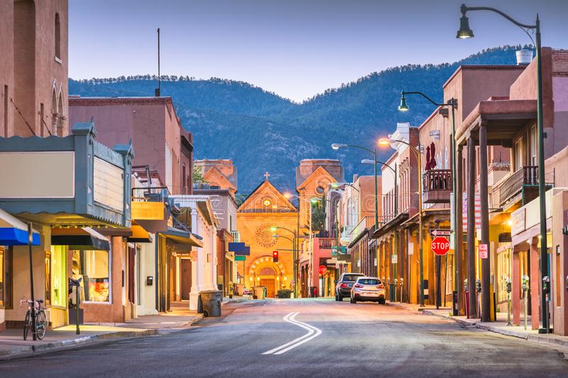
Most recently updated on March 4, 2024
Driven on March 23-24, 2022
Originally posted on March 23, 2021
In old cartoons, there are numerous moments when Bugs Bunny pops out of a hole in the ground only to discover he is lost.
In each instance, he checks a map and then declares, “I knew I should have made a left turn at Albuquerque.”
That’s what we’re doing leaving this high altitude city this morning and heading north on Interstate 25.
On the agenda for today is a trip back into the beginnings of our nation’s Atomic Age as well as the eerie landscape in the middle of this state that has led to a culture of UFO believers.
Interstate 25 travels slightly more than 1,000 miles from southern New Mexico near the Mexico border all the way to northern Wyoming near its border with Montana.
We’ll be on this freeway for only an hour today, cutting through open land in north-central New Mexico. As we near the state capital of Santa Fe, we take another left to head north on Highway 599 before connecting to Highway 84.
We make one more left on Highway 502, heading into the mountains of the Santa Fe National Forest before reaching our first destination. This four-lane roadway heads due east before narrowing to just two lanes and snaking up a mountainside into Los Alamos.
The small town doesn’t look like a place where a secret project was hatched to build the world’s first atomic weapon.
But that’s exactly what it is.
The town sits on one of the four mesas of the Pajarito Plateau at an altitude of 7,300 feet. This is the highest elevation we will reach in our cross-country journey.
The first permanent residents were Puebloans who arrived around 1200 and built homes on the cliffs and farmed in the valleys below. A second migration occurred around 1300 with Native Americans from the Four Corners area. By 1550, those settlements had disappeared due to drought as well as attacks from Navajo, Utes, Apache and Cherokee.
In the 1800s, Spanish settlers established villages on the plateau. The Santa Fe Trail and the Rio Grande Railway brought in homesteaders who built log cabins and raised livestock.

In 1918, the Los Alamos Ranch School was established by entrepreneur Ashley Pond. The school was an outdoors-focused program for boys. The campus included 27 homes and 27 other buildings that included the school, a small sawmill, barns and an arts and crafts building. Pond named the town Los Alamos after the Spanish word for the area’s cottonwood trees.
In 1942, everything changed.
The U.S. military chose Los Alamos as one of three locations in the country for the Manhattan Project to develop the atomic bomb because of the site’s isolation and inaccessibility. The military also liked the school buildings and the way the town was set up. So, they snapped up all the property and moved everybody out.
A community for lab employees was hurriedly built. Everything was top secret.
When they left their homes from across the country, the 6,000 lab employees couldn’t tell their family and friends where they were going. The town name did not exist on driver’s licenses, birth certificates or mail. All the employees’ addresses were listed as P.O. Box 1663.
The community was self-contained with homes, a hospital, schools and theaters.
The secret facility was known as Site Y by the government and The Hill by the people in nearby towns.
That lab was where the first atomic device simply known by lab engineers as “The Gadget” was slowly and carefully assembled from materials developed by the other Manhattan Project locations. Those experimental bombs were tested in remote areas in other parts of the state. We’ll visit one of those places later today.
The lab was supposed to be closed after World War Two. The town, in fact, declined in the late 1940s.
Then, the Cold War with the Soviet Union happened.
Los Alamos was revived in the 1950s as scientists again crammed into the renamed Los Alamos National Lab to help the United States keep up with the Soviets in the arms race.
The hydrogen bomb was developed here and the town was restricted to lab employees until 1957 when it was opened up again.
Today, the lab still sits south of downtown in an isolated area. It consists of 300 buildings on 77 square miles. Scientists work on solar and nuclear research. The lab employs more than 11,000 people. About 45 percent of them live in Los Alamos County.
The salaries paid at the lab are the main reason Los Alamos’ median annual household income is $135,000, well more than twice the state average. The town of 13,000 also has one of the highest concentrations of millionaires per capita in the United States. The median home price is about $520,000, about $200,000 higher than Albuquerque. Less than 4 percent of the population lives below the poverty line.
There was a price to pay for all this success. Radioactive waste from the lab operations over the decades has leaked underground in Los Alamos and other nearby towns. There are also 2,000 sites around the lab where trash, including washing machines, were dumped.
It’s estimated it’ll take $4 billion and 20 years to clean up. Nearly 5,000 lab workers have received $566 million over the years for health problems related to their work.
Still, the town takes pride in its place in U.S. history. It embraces the nickname Atomic City with themed merchandise sold around downtown.

An exhibit at the Los Alamos History Museum
The Los Alamos History Museum tells the history of the town from its Native American beginnings to its atomic lore. It covers the school, the building of the secret town and what followed after World War Two.
On a visit there in March 2022, 60 Days USA spoke to Jeff Berland, who along with his wife and three young children had traveled from Boulder, Colorado, to see the town and the museum during their spring break from school.
“It’s an interesting look at what is relatively modern history,” Berland said.
Richard Shaner, who was working at the front reception desk on this day, said the museum details a key piece of 20th century history.
“It’s an important look at something that changed the course of history,” he told 60 Days USA.
On this day, the museum had a steady stream of visitors.
The complex may become even better known now. Shaner said Matt Damon and Robert Downey Jr. had been in town the week before filming the movie, “Oppenheimer” about the Manhattan Project. The film was released in July 2023.
In addition, on the day of our visit, a Canadian film crew was out front getting footage for a television series on U.S. history.
A few blocks from the museum is the Bradbury Science Museum, named after Manhattan Project Director Norris Bradbury. The facility has been welcoming visitors since 1993. It has three main halls that specialize in history, research and defense.
One of the town’s well-known public figures is New Mexico Governor Michelle Lujan Grisham, who was born in Los Alamos and graduated from high school in Santa Fe.
————————————————-
We retrace our steps back through the high desert mountains as we head toward New Mexico’s state capital.
As we drive along Highway 502 east and Highway 84 south, we pass by communities that are quite different from Los Alamos.
Towns such as Pojoaque, Cuyamungue and Tesuque have 2,000 or fewer residents, the vast majority of whom are Hispanic. The citizens here earn significantly less than their counterparts in Atomic City. That still puts them at between $50,000 and $90,000 per household per year with poverty rates of less than 15 percent.
After 40 minutes on the mountain highways, the city of Santa Fe spreads out before us.
The nearly 90,000 residents here also earn about half of what their neighbors in Los Alamos make, but this community isn’t like the ones we just passed.
Santa Fe is not only a state capital, it’s a thriving community for both artists and writers.
It’s also been around a long time.
The first residents were Pueblo tribe members who established settlements along the Santa Fe River around 1050.
Spanish settlers eventually arrived, officially establishing the town in 1607. That makes Santa Fe the third oldest city founded by European colonists in the United States, behind St. Augustine, Florida, and Jamestown, Virginia.
The town was named as a province capital in 1610, marking Santa Fe as the oldest state capital in the country. It achieved that status 20 years before the next state capital, Boston, was selected.
Santa Fe’s altitude of 7,198 feet is the highest elevation of any state capital. It also is home to the nation’s oldest community celebration with the Santa Fe Fiesta, which began in 1712 and is still held every September.
In the 1800s, the city was a major stop on the Santa Fe Trail. In 1880, a branch line of the Atchison, Topeka and Santa Fe Railroad brought even more traders and travelers.
Shortly after New Mexico’s statehood in 1912, Santa Fe became a tourist attraction as well as a haven for artists because of its beauty and dry climate. A writers’ colony also sprung up between World War One and World War Two.
A more dubious part of the city’s history emerged during that second world war. Between 1942 and 1946, more than 2,000 Japanese Americans were housed at an internment camp here. They were part of the 117,000 people of Japanese descent who were put in these isolation centers nationwide. Most of them were U.S. citizens. Canada and Mexico had similar programs, although not nearly as many people were affected.
After the war, that episode seemed to be quickly forgotten as Santa Fe’s tourism industry continued to expand. Today, more than 1 million people visit in a typical year.

Visitors inside the Georgia O’Keeffe Museum in Santa Fe, New Mexico. Photo by the Georgia O’Keeffe Museum.
The city’s architecture draws some of the travelers. In the 1920s, the city developed a Spanish Pueblo Revival look that is evident in the downtown’s main plaza. In 1958, a law was approved that requires new and rebuilt buildings to reflect that style.
The artists’ contingent is still strong. The city boasts more than 250 art galleries. More than 80 of them are along a one-mile stretch of one-lane Canyon Road. Those galleries are mostly regional artists displaying their works
The Georgia O’Keeffe Museum opened in 1997. The museum features the works of the Wisconsin-born artist who lived in New Mexico from 1949 to her death in Santa Fe in 1986. The collection contains more than 3,000 of O’Keeffe’s works, including 140 oil paintings and 700 drawings. The museum association also oversees two of O’Keeffe’s homes as well as one of her studios, a research center and a library.
Santa Fe’s commitment to art brought it the distinction in 2005 as being the first U.S. community to be designated as a Creative City by UNESCO.
Gene Hackman enjoys life here. The 94-year-old Oscar-winning actor has lived in Santa Fe with his wife, Betsy, since 1991.
Ali McGraw, the actor best known for “Love Story,” also lives here, moving to Santa Fe about 25 years ago after her house in Malibu burned down.
And actor Robert Redford owns a 250-acre ranch outside Santa Fe.
UFO Territory
Out of Santa Fe, we turn southward to begin a long drive through the middle of New Mexico.
Highway 285 takes us through vast stretches of open land punctuated by small towns such as Lamy, a community of 200 known for its train station, and Young Place, a community of 100 that in contrast to its name has a median age of 56.
The landscape here is high desert chaparral dotted with large windmills in the distance and the occasional antelope or herd of cattle.
An hour after leaving the state capital, we stop at Clines Corners, a 30,000-square-foot retail center that greets travelers where 285 intersects with Interstate 40 about an hour east of Albuquerque.
The center was started in 1934 by Roy Cline, who opened a gas station and a café near here. He moved his business to its current location in 1937 after Route 66 was realigned. Cline sold the operation to S. Lynn “Smitty” Smith and his wife in 1939. The center prospered and the Smiths expanded it over the years. When Smith died in 1961, his wife sold the property. It’s had three different owners since.

Clines Corners at the intersection of Interstate 40 and Highway 284 in the middle of New Mexico
The center today consists of two gas stations, a 36-space RV park, two restaurants and New Mexico’s largest gift shop.
During a visit by 60 Days USA in March 2022, a steady influx of customers bought gas, souvenirs and snacks.
Starla Burkhalter was one of the employees working the registers.
She said the most common destinations of the folks who stop in are Arizona and Texas. She noted business had picked up noticeably as COVID-19 restrictions were loosened across the nation.
——————————————————-
You get an appreciation for just how big New Mexico is when you drive across it.
We continue south from Clines Corners on Highway 285 through more of the state’s highlands. There’s almost three hours of driving before we stop again.
We glide onto Highway 3 south for a short distance before we join Highway 54 and head in a southwesterly direction. An hour after leaving Clines Corners we zoom through the town of Corona.
This community of 130 people was settled by Spanish ranchers who raised sheep and cattle on the open range land here.
It became a stop for stage coaches and then a depot for the railroad. The rail line helped develop the mining industry in the nearby Gallinas Mountains.
The railroad and the mining industries have all but disappeared, but Corona has remained a ranching community, although that may now be changing. In September 2023, ground was broken on the SunZia wind energy project just north of town. When it’s completed in 2026, the development’s transmission’s lines will carry 3 gigawatts of electricity to customers in central New Mexico and south-central Arizona. SunZia is the largest clean-energy project ever built in the United States.
What marks Corona on our map, however, is the fact the community was the closest inhabited area to a mysterious 1947 crash that helped start the UFO culture in New Mexico.
Corona residents learned about the incident 30 miles to the southeast when a farmer came into town talking about some chunks of metallic material he found on his property.
A team from the Roswell Army Air Field retrieved the wreckage. The military initially said the debris was from a weather balloon. Eventually, they admitted it was from a spy balloon from a secret espionage project known as Project Mogul.
Some conspiracy theorists, however, weren’t buying the explanation. They were adamant that the debris was from a spacecraft with extraterrestrials whose alien bodies were taken to a secret base near Roswell known as Area 51.
Their theory was fueled in the 1950s by the discovery of an initial military press release that described the scattered metal as a flying saucer and from the “dummy drops” conducted in the region by the military to test the effects of pilot ejections from high-flying aircraft.
Interest in the conspiracy expanded after the movie “Star Wars” hit the theaters in 1977. A 1980 book, “The Roswell Incident,” furthered interest even more. The phenomenon was captured in a Time magazine cover story in 1997 during the height of “The X=Files” television show.
The town of Roswell, an hour and a half southeast of Corona, has embraced the UFO culture. There’s no shortage of extraterrestrial-related merchandise sold at shops downtown.
As part of the tourism effort, there’s an International UFO Museum and Research Center that opened in 1992. The facility provides a mix of education and fun. The history of the UFO controversy is well detailed amid some entertaining exhibits featuring space aliens.
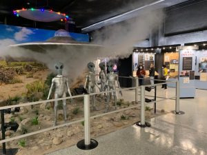
An exhibit at the UFO museum in Roswell, New Mexico
We stopped by in March 2022 and spoke to Mike and Jennifer Simone of Boulder, Colorado. They were on a road trip and wanted to learn more about the Roswell UFO connection. They were not disappointed.
“We thought it was very interesting,” Mike said.
At the front counter, Beth said the museum gets people from all over the world. She said most people come in out of curiosity.
“I’ve had so many people tell me this has been on their bucket list forever,” she said.
The town hosts also an annual UFO Festival in July that includes a costume contest, an Alien Chase road race and a UFO festival light parade.
Even the minor league baseball team gets into the act. The Roswell Invaders players wear lime green uniforms in recognition of the town’s UFO reputation.
Roswell is also home to the New Mexico Military Institute, an academy for high school and community college students that has been around since 1891. Each year, the institute starts with 1,000 cadets, although that number dwindles during the year under the school’s rigorous standards. NMMI, also known as the “West Point of the West,” is the only state-supported co-educational college preparatory high school and junior college in the United States.
Atomic Wasteland
Back on Highway 54 we drive through the village of Tularosa.
This community of 2,600 people is named after the rose-colored reeds that grown along Rio Tularosa, but it’s better known for its cottonwood trees.
The town was established in 1863 on 1,400 acres as a 49-block farming community. The original irrigation ditches are virtually unchanged today. The original settlement and its 185 buildings were placed on the National Register of Historic Places in 1979.
Just south of Tularosa is the White Sands Missile Range, a facility that was established shortly after the Japanese bombing of Pearl Harbor in December 1941.
On July 16, 1945, the range was the site of the first detonation of a nuclear device. The explosion was known as the Trinity Test, which was a piece of the Manhattan Project.
The device that was detonated was the “Gadget” that was assembled in Los Alamos. The explosion released the equivalent of between 15 kilotons and 20 kilotons of dynamite.
Two similar bombs were dropped on Japan less than a month later.
The missile site was designated as a national historic landmark in 1965. The area still has 10 times the amount of natural background radiation found in most places. Nonetheless, public tours are conducted during the first week of April and the first week of October.
The people who lived near the missile range in 1947 reported seeing a bright light and hearing a loud explosion the day “Gadget” was unleashed.
Residents who now live in the area say their communities were contaminated by radiation for years, causing a number of cancer clusters.
In 2005, Tina Cordova and Fred Tyler formed the Tularosa Basin Downwinders Consortium to investigate the long-term health effects of the explosion on their valley.
Cordova, who grew up in the Tularosa Valley but has lived in Albuquerque most of her adult life, told 60 Days USA in spring 2021 that she had just finished treatment for thyroid cancer in 2005 when she read an editorial in the local newspaper by Tyler about his family and his community’s problems with cancer in the shadow of the Trinity test.
He and Cordova met and formed their group.
The organization’s main goals are to compile a database on diseases as well as get New Mexico residents added to the federal Radiation Exposure and Compensation Act (RECA) for victims of the atomic testing we discussed on Day 2 of our trip. The program now only includes Nevada, Utah and Arizona.
Cordova and others testified before the House Judiciary Committee on March 24, 2021, about the need to expand eligibility under the compensation act. In September 2021, a bill was introduced in Congress to amend RECA to include New Mexico in compensation programs. That legislation has not made it to the House floor yet.
Cordova’s consortium also holds protests outside the missile range site as well as an annual vigil in July.
So far, the basin residents haven’t received any compensation, although President Joe Biden said in August 2023 that he was open to granting assistance to people exposed to radiation during nuclear weapons testing.
Cordova says there’s no question this region has suffered from the fallout of the 1945 Trinity explosion. She says there were tens of thousands of people who lived within 50 miles of the blast, some as close as 12 miles.
She said the Trinity device was poorly constructed and detonated on a raised platform, sending radioactivity in all directions but especially in the downwind direction of the Tularosa Valley. The region had no running water then and most residents grew their own food, so the locals basically breathed, ate and drank microscope radioactive particles.
“Our entire environment was destroyed,” Cordova said.
Cordova said her family and virtually every family she knows developed illnesses in the decades following the explosion. Her father was among them, dying of cancer in his early 1970s.
So, she and Tyler established a registry of personal stories from people who have lived in the valley since the nuclear test.
“We decided if the government wasn’t going to do anything to account for this, that we were going to keep track and make sure people’s stories were documented and people were recognized for their suffering,” Cordova said.
She said her state seems to be in a “sacrifice zone” when it comes to uranium mining, storage of hazardous waste and radioactive fallout. She suspects part of the reason is because New Mexico has one of the highest percentages of non-white populations, a condition she labels as “environmental racism.”
“The people of New Mexico are easily regulated to this position of nothingness where we don’t really count too much,” Cordova said.
She said compensation can help make up for the “huge economic consequences” families have suffered when people lose jobs and rack up expensive medical bills due to illnesses brought on by lingering radioactivity.
She notes the danger to the valley isn’t going to dissipate any time soon. The plutonium used in the Trinity blast has a half-life of 24,000 years.
“This is never going to go away,” Cordova said. “We shouldn’t have to shoulder this burden on our own.”
—————————————
One of the towns within the umbrella of the radiation fallout was Alamogordo, which sits along Highway 54 just east of the missile range.
Native Americans settled in the area 10,000 years ago. Apache tribes were there when the first Spanish explorers arrived in 1534.
The current town was established in 1898 for people working on the El Paso and Northeastern Railroad. It was named Alamogordo, which translates into “fat cottonwood,” for the trees that are abundant here.
The city was incorporated in 1912 as a planned community with wide thoroughfares and tree-lined irrigation canals. The east-west streets have numerical designations while the north-south streets have state names.
Many of the buildings that stand today were built in the late 1930s under the Works Progress Administration. They include the Otero County Administration Building and the Alamogordo Women’s Club.
The Works Progress Administration was created in 1935 as part of President Franklin Roosevelt’s New Deal programs to lift the country out of the Great Depression. The agency operated until 1943 when World War Two production eliminated the need for it.
The WPA employed 8.5 million Americans in 1.4 million projects. These included 4,000 new schools, 130 new hospitals, 9,000 miles of storm drains and sewer lines as well as 29,000 bridges, 150 airfields, 280,000 miles of road paving and the planting of 24 million trees. Among its famous projects are Hoover Dam in Nevada and the Library of Congress in Washington, D.C.
During its eight years of existence, the agency spent $11 million on construction projects as well as art projects for artists, writers and musicians. There were 2,566 murals painted and 17,774 sculptures crafted for public buildings.
A 1939 Gallup poll revealed the WPA was the most liked as well as most disliked of the New Deal programs.
Critics said it was inefficient with projects costing three to four times what they would have under private management. They also noted that workers only earned an average of $41 per month.
Supporters, however, say the program was essential. They note that from 1929 to 1933 unemployment rose to 25 percent and family income dropped by 40 percent. In addition, 750,000 farms were lost, 300,000 companies went out of business and 11,000 banks failed.
For towns like Alamogordo, the WPA was a lifeline sent from heaven.
The economy here was also bolstered by the opening in 1942 of Holloman Air Force Base. The 60,000-acre military installation has been a center for pilot training.
The base continues to fuel Alamogordo’s economy today. Holloman supports 21,000 active duty, reserve and guard members. This base and the nearby White Sands Missile Range have a combined payroll of $200 million and contribute an estimated $450 million to the local economy.
In recent years, the city has used financial incentives to lure companies. A 1-800-Flowers call center opened at one point as did a Western Baking Company cookie manufacturing plant.
The Otero County Film Office has promoted the region to filmmakers. Some scenes from the 2007 “Transformers” movie were shot in the region.
Jan Wafful, the film liaison for the office, told 60 Days USA in 2021 that the region has quite a history of filmmaking.
She says the first three movies shot here were a trio of westerns filmed in 1911. The first major studio to film in the county was Paramount when it produced the short documentary “Moon Rockets” in 1947.
The 1950s version of “King Solomon’s Mines” was also reportedly filmed here as was the Oscar-winning “Around the World in 80 Days.” The Clintwood Eastwood epic “Hang ‘Em High” also had scenes shot in Otero County.
There’s a lot more to this history. If you’re interested, you should contact Wafful. She knows all about it.
Despite the film industry, this region has been deficient in keeping up with technology. That is slowly changing. Tularosa Communications is spotlighted in a PBS documentary for its efforts to bring broadband connections to rural communities such as the ones in this New Mexico valley. The utility has been installing fiber optic cables in homes as well as increasing Internet speeds. The move came in handy when area schools turned to digital learning during the COVID-19 pandemic lockdowns.
Speaking of science, the city does boast one famous resident along those lines. Alan Hale, the co-discoverer of the Hale-Bopp Comet, grew up in Alamogordo.
Gypsum and Galactic Travel
We’ve descended 3,000 feet in elevation since leaving Santa Fe as we enter the southern reaches of New Mexico where the terrain is a little drier and more desert-like.
On the outskirts of Alamogordo we pass by PistachioLand, an 11-acre orchard with 12,000 pistachio trees that was established in 1980.
A short time later, we take a right and head southwest on Highway 70.

White Sands National Park in New Mexico. Photo by Multibrief.
It doesn’t take long to reach White Sands National Park.
Like the Grand Canyon and the Barringer Meteorite Crater, you have to actually see this natural wonder to appreciate it.
The park is exactly what the name implies. It is miles and miles of rare white gypsum sand dunes.
The 775 square miles of white sand, some of which is located on the nearby military bases, is the largest gypsum dune field on Earth.
The landscape was formed in prehistoric times when a shallow sea covered the region. When the waters receded, the gypsum was left behind. This basin has no outlet to the sea, so when the water evaporates, the gypsum hardens and crystallizes.
Native tribes hunted mammoths, bison and camels here 10,000 years ago. Apache contingents lived here when the first U.S. Army expedition came through in 1849.
In the early 1900s, the fields were threatened by entrepreneurs who wanted to use the gypsum to manufacture products such as plaster of Paris, drywall and toothpaste.
The damage was avoided when the white fields were dedicated as a national monument in 1933. They were designated as a national park in 2019.
Once you’re here, you can hike on the sand or take your car on the 8-mile Dunes Drive. Or you can simply enjoy the view from the visitors’ center.
During a visit by 60 Days USA in March 2022, dozens of vehicles were parked along the road as people walked up the dunes while children slid down the sides in sleds.
Becky Parmeter lounged with a friend in foldable chairs while their three children enjoyed some sledding. The Las Cruces resident said this was her 4th or 5th visit to the dunes. She said it’s a great place to relax while her kids burn off some energy.
In the visitors’ parking lot, Cindy and Mark Wanken of Iowa were preparing to leave. Cindy retired a few months ago and this was the couple’s first post-work road trip. They had just visited family in San Antonio, Texas, and were on their way to Colorado. Cindy said she had seen the white sands park on a map and was intrigued. She and her husband both said they felt the stop was definitely worth their time.
—————————-
We get back on Highway 70 after leaving the beautiful white sand dunes.
You can tell we’re within 100 miles of the Mexican border due to the U.S. Border Patrol station on this roadway. It’s one of many checkpoints that ring the country around our borders on both coasts as well as within range of Canada and Mexico.
We continue southwest on Highway 70 as we near our final destination for the day.
We pass by the White Sands Missile Range Museum, which is basically a park with old missiles and rockets stuck in the ground, pointing skyward.
Highway 70 takes us into downtown Las Cruces.
With a population of 116,000, Las Cruces is the second most populous town in New Mexico, behind only Albuquerque. Almost 62 percent of the residents are listed as Hispanic or Latino.
Native American tribes began living here about 20,000 years ago. They had mostly disappeared when Spanish explorers first arrived in 1535. The city became part of Mexico in 1821 and then was annexed into the United States after the Mexican American War in 1848.
The railroads came through in the late 1800s and the city incorporated in 1907.
Today, Las Cruces is where Interstate 25 and Interstate 10 converge. It was listed as the fastest growing city in New Mexico between 2010 and 2020.
Agriculture is a big part of the economy. Peppers are the hottest commodity. Chile, cayenne, jalapeno and bell peppers of all colors are grown locally. In addition, Stahmann Farms south of town is one of New Mexico’s largest pecan growing operations.
The city’s manufacturing sector was helped by the NAFTA agreement in 1994 as well as by the 1991 opening of the border crossing near Santa Teresa, just 40 miles to the south.
With 340 days of sunshine a year, Las Cruces also has a growing renewable energy industry.
New Mexico State University is also here, so education is another economic component.
In addition, Las Cruces has had a thriving defense and aerospace industry.
A big reason is the city is the corporate headquarters for Spaceport America. The company oversees a launch facility about an hour north of town along the I-25 corridor. It’s described as the world’s first purpose-built commercial spaceport.
The FAA-licensed complex sits on 18,000 acres of desert. It was built with the help of a $220 million investment from the state. The companies located here include Virgin Galactic as well as HAPS Mobile, UP Aerospace and Spin Launch. Some of the spacecrafts are the ones that were built and tested at the Mojave, California, facility we visited on Day 1.
Spaceport America was cleared for flight in 2010, but for years it was more a tourist curiosity than an operational space launching pad. However, in summer 2020 it was the site of several successful suborbital flights of futuristic space vehicles. The hope originally had been to send private citizens into space by 2020, but the COVID-19 pandemic slowed that progress.
In July 2021, Virgin Galactic owner Richard Branson joined crew members on a short suborbital test flight slightly above the 50-mile threshold of outer space. In August 2023, the company completed the first space flight for tourists when three crew members and three private citizens flew on the Galatic 02 on a suborbital flight that reached a height of 44,000 feet.
The Spaceport complex also hosts the Spaceport America Cup in June with more than 1,500 college rocket engineering students and faculty participating.

Hotel Encanto Las Cruces in New Mexico. Photo from Tripadvisor.
Downtown Las Cruces itself is in the midst of a long rebuild. An urban renewal project begun in the 1960s tore down a lot of historic buildings and closed seven blocks of Main Street. A 2008 plan to restore some of the downtown core is now in full gear.
One of the crown jewels downtown is the Hotel Encanto de la Cruces. It’s designed with Spanish and Mexican colonial history in mind. It’s also the place where Virgin Galactic puts up its guests.
Another businesses that remains open is the Pecan Grill, one of the more popular restaurants in town. The eatery is known for its selection of craft beers and its southwestern food.
We’ll pull up a chair and rest here for today.
Tomorrow, we’ll be busy cruising along the U.S.-Mexico border.