
Day 55: On the Road in Idaho
May 13, 2021
Day 53: Wandering Through Wyoming
May 11, 2021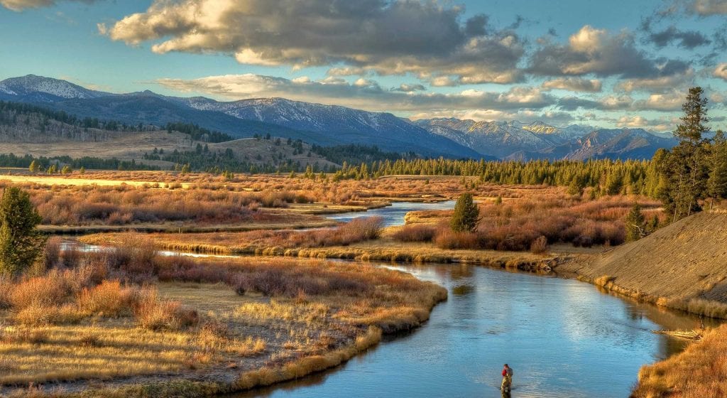
Most recently updated on June 17, 2024
Originally posted on May 12, 2021
Yellowstone was the world’s first national park.
It’s home to bears, wolves, antelope, elk, bison and other animals.
Half of the world’s geysers are in this 28,000-square-mile preserve that sits in three states.
There’s so much to see, but first we have quite a journey on which to embark to get there.
We’ll start by departing from Billings, Montana, taking Highway 3 north until it junctions with Highway 12. From there, we head west. After more than an hour on the road, we arrive at Harlowton.
This town of less than 1,000 people is surrounded by the Crazy, Little Belt and Big Snowy mountains.

In prehistoric times, the region was known for its herds of bison. Tribes such as the Crow and the Blackfeet hunted in the area. The Crow and Sioux had a 35-mile-long row of stones that marked each other’s hunting grounds.
An 1868 treaty between the Crow tribe and the U.S. government opened the area to settlement. A sheep ranch was established in 1878. The Chicago Montana Livestock Company started a cattle operation in 1882.
The town was founded in 1900 as a stop on the Montana Railroad. The community was named after Richard Harlow, the president of that railway. In 1907, a roundhouse was built in Harlowton for the Chicago, Milwaukee, St. Paul and Pacific Railroad. The first passenger trains came in 1908.
From 1915 to 1974, Harlowton was the eastern terminus of the electrified Pacific extension of the CMS&P Railroad. The railroad’s route was known as the Milwaukee Road. It was here that steam and diesel locomotives were switched out or hooked up to electric locomotives for the 430-mile trip to Avery, Idaho.
The railroad stopped its electrified service in 1974. The last train went through Harlowton in 1979. The depot is now Harlowton Milwaukee Depot Museum. The E-57B electric train engine sits in the town’s center.
This region has always been a rich agricultural area with crops such as wheat, barley and oats as well as cattle, sheep and bees. There are a lot of supporting businesses, including feed stores, saddle repair shops and ranch supplies.
North of town off Highway 191 is the Judith Gap Wind Energy Center owned by Invenergy, a private firm with 180 projects on four continents. The Judith Gap facility which was built in 2005, has 90 towers that produce 150 kilowatts of power each that is fed into the Northwest energy grid.
At one time, Judith Gap was the largest wind farm in Montana. It was surpassed in 2012 by the Rim Rock Wind Farm in northern Montana. Rim Rock will soon be eclipsed by the Clearwater Wind Project. The first phase of the 775-megawatt facility is operating, producing 365 megawatts of power. The project east of Billings has contracted to provide electricity to a power plant system that has customers in Oregon and Washington.
To Grandmother’s Town We Go
Instead of heading north on Highway 191 to Judith Gap, we swing west on Highway 12 for a one-hour drive to White Sulfur Springs.
The community of almost 1,000 people is near three mountain ranges – the Little Belt, the Big Belt and the Castle. It’s also near the Lewis and Clark National Forest and is considered the gateway to the Smith River State Park, a popular trout fishing location that hands out permits via lottery every year.

The Spa Hot Springs Motel in White Sulfur Springs, Montana. Photo by Ultimate Hot Springs Guide.
As its name implies, the town is known for its therapeutic water, but I know it better as the town where my grandmother was raised.
Geraldine Mason was born in Butte in 1913, but she grew up in White Sulfur Springs and had plenty of stories to tell about it. Gram, as she was called, loved the outdoors of Montana and the charm of her small town. Her ancestors were part of The King’s Daughters, a group of 768 women from France who arrived in New France (now Canada) between 1663 and 1673 at the behest of King Louis XIV to help populate the region. Gram’s grandparents on her mother’s side were born in the Quebec area.
Native American tribes lived in the White Sulfur Springs area for centuries and called the region the Valley of Peace. The first European visitor was in 1886, just 27 years before my grandmother lived here. Buffalo, cattle, lead mining and silver mining were big parts of the economy.
White Sulfur Springs became famous for its mineralized hot springs. The Spa Hot Springs Motel has three mineral hot springs. The spa was built in the 1860s. John Ringling of circus fame bought the property around 1900 and sold it during the Great Depression.
Another historical building here is The Castle mansion, which was built in 1892 by B.R. Sherman. The 12-room home is now the Meagher County Museum. A carriage house was constructed behind the mansion to store antique carriages, sleds and other artifacts.

Some of the action at the Red Ants Pants Music Festival in White Sulfur Springs, Montana. Photo by Red Ants Pants Music Festival.
For something fun, there’s the Red Ants Pants Music Festival, which occurs in July.
The festival was founded in 2011 in a cow pasture. About 6,000 people attended the first festival. In the past, singers have included Merle Haggard, Emmylou Harris, Dwight Yoakum and Wynonna Judd.
The event raises money for the Red Ants Pants Foundation, which provides funds for women’s leadership programs, working family farms and rural communities.
The festival and foundation were started by Sarah Calhoun, who established the Red Ants Pants company in 2006 in an historic saddle shop because she was tired of women’s work pants that didn’t fit.
Where the Missouri Begins
We indeed have ants in our pants as we have a lot of driving still ahead of us today.
So, we continue on Highway 12 west and then take Highway 287 south. After almost an hour and a half we arrive at Three Forks, a community of 1,800 people at an elevation of 4,075 feet in southwestern Montana.

Some of the collection at the Headwaters Heritage Museum in Three Forks, Montana. Photo by DestiMap.
The town is so named because it’s located four miles from where the Jefferson, Madison and Gallatin rivers come together to form the Missouri River. The water from these headwaters eventually flows into the Mississippi River and continues all the way to the Gulf of Mexico. The spot where the Mississippi and Missouri rivers meet is at the Edward “Ted” and Pat Jones Confluence Point State Park in Missouri that we highlighted on our Day 41 adventures.
Native American tribes, including the Crow and Blackfeet, hunted in the Three Forks region for centuries.
Explorers Meriwether Lewis and William Clark visited the area in 1805. Lewis named the three rivers for President Thomas Jefferson, Secretary of State James Madison and Treasury Secretary Albert Gallatin. Their entire journey, including their stop in Three Forks, is chronicled in great detail in the book, “Undaunted Courage,” by Stephen E. Ambrose.
The city of Three Forks has a statue in a park honoring the Native American guide Sacagawea who helped Lewis and Clark.
The Chicago, Milwaukee and St. Paul Railway reached the area in 1907. The town was founded in 1908 by John Q. Adams, a Milwaukee Road railroad land agent. The Milwaukee Land Company, which was owned by the railroad, platted the town the same day as the founding. Hunters and trappers were among the first settlers from 1908 to 1910. There were 800 residents by 1909. The Northern Pacific Railroad also had a depot in town. Three Forks was a railroad hub from 1908 to 1980, when the final Milwaukee train departed.

The Sacagawea statue in Three Forks, Montana. Photo by TripAdvisor.
The community has grown recently due in part to the booming economy of nearby Bozeman, where we are headed next. Three Forks still has a cement plant and a talc plant as well as a Wheat Montana. facility.
The Headwaters Heritage Museum preserves the history of the Missouri headwaters region. The complex opened in 1982. Among its exhibits are one of the oldest anvils made in this country, the largest brown trout ever caught in Montana, a dugout canoe and a log cabin.
If you’re hungry while in town, you might stop at the Iron Horse Cafe & Pie Shop, a restaurant that specializes in soups and pies. It’s been owned and operated since January 2018 by Jamie and Parker Taylor. The couple bought the restaurant after Jamie lost her job in 2017 and she was home testing pies for Thanksgiving. The pies were apparently a hit from the moment the Parkers started serving them.
—————————————-
We hop back on Interstate 90, this time headed east.
After a half-hour, we pull into Bozeman, the fourth most populous town in Montana with 58,000 residents.
It’s a city whose economy is changing but not to the delight of everyone.
Native tribes, in particular the Crow, lived in this region they called the “Valley of the Flowers.”
The town was founded in 1864 by John Bozeman, the pioneer of the Bozeman Trail that was in essence a shortcut to Montana’s gold fields in the 1800s. The area’s fertile land attracted settlers, many of whom grew potatoes and wheat. Fort Ellis was built in 1867 and the Northern Pacific Railway arrived in 1883. The area’s first cattle ranch was established in 1886. Montana State University opened in 1893.
In early 1900s, peas were planted in the Gallatin Valley. Several processing facilities opened in Bozeman. At one time, the valley produced 75 percent of the seed peas in the nation.
The region was once served by Hiawatha Railroad trains that chugged between Chicago and Seattle through Bozeman, Billings, Helena and Missoula. That line was shuttered by Amtrak, but residents of rural Montana are hoping President Joe Biden, a big fan of trains, may find a way to bring it back.
Even without the Hiawatha line, the economy in the Bozeman area has been booming lately with high tech, biotech and software companies. It was reported that in 2019 Montana’s high tech sector was growing 9 times faster than the state’s overall economy. That pace continued into 2020 when the Montana High Tech Business Alliance touted Bozeman as the state’s tech hub due to the presence of Montana State University and other factors. A high–tech summit was held in Bozeman in June 2022, highlighting the opportunities for that industry in Montana. In October 2023, Missoula and Bozeman were named by federal officials as the two “tech hubs” for the state of Montana.
Bozeman Yellowstone International Airport has proven to be a popular place to fly due to its lower airfare prices. In December 2021, it was announced that the airport would receive $4 million in 2022 for improvements under President Joe Biden’s infrastructure plan. The airport is seeing such an increase in traffic that in October 2023 it once again had federal TSA officers overseeing security for the first time in 8 years. The move was made because staff shortages under a private contractor had been causing long delays at security gates.
For some residents, all this growth is a bit too much. They aren’t keen on large companies from other places plunking down in a state that was built on home-grown industry. Some residents even drive with bumper stickers on their cars that say “Make Bozeman Montana Again.” Their concerns were on display in August 2022 at a hearing where city officials discussed plans to build an extension of Fowler Avenue through greenspace to accommodate traffic growth.
There are some places to visit here that remain very Montana.

Some of the exhibits at the Museum of the Rockies in Bozeman, Montana. Photo by the Museum of the Rockies.
Bozeman is the locale for the Museum of the Rockies. The facility, which opened in 1957, has exhibits that include dinosaur, the cultural history of Montana and the history of Rocky Mountains. It also houses the Siebel Dinosaur Complex with a vast collection of Tyrannosaurus Rex specimens.
The town is also home to the Montana Grizzly Encounter, which opened in 2004. The facility provides a sanctuary for grizzly bears born in captivity as well as educating the public about the animals.
Finally, Bozeman is the headquarters of the American Prairie Reserve, an effort that began in 2000 with its first property purchased in 2005. The organization’s goal is to turn open land in the high plains surrounding the Missouri River in northeastern Montana into the largest national reserve in the continental United States.
In their book “Our Towns,” James and Deborah Fallows detail how the trust is buying ranch land as well as taking over leases of government acreage. They take down fences and halt grazing practices to return the land to natural habitat for bison, antelope, wolves, prairie dogs and other animals.
The group began a 15-year Land of Legacy campaign in 2016. The ultimate goal is to preserve 3 million acres, a campaign that could cost as much as $500 million.
A story in the September 2019 issue of Sierra magazine discussed the ongoing campaign and the resistance to it from some ranchers, especially in the community of Malta in northern Montana. The group, United Property Owners of Montana, has also launched an effort to counter the American Prairie Reserve’s efforts, saying it will destroy family ranches. Their slogan is “Save the Cowboy, Stop American Prairie Reserve.” This battle over Montana’s land is a central theme in the television show “Yellowstone” starring Kevin Costner.
Grizzlies and Wolves
We leave Bozeman and take a straight south on Highway 191 for almost 2 hours.
Along the way, we cross the 45th parallel, that imaginary line halfway between the equator and the North Pole, for a fourth time.
The highway eventually takes us to the edge of Yellowstone National Park. We will venture into the natural wonder tomorrow.
Today, our final destination is the town of West Yellowstone, a community of nearly 1,200 people that serves as the western gateway to the park. There’s plenty to explore here.

It can get cold in West Yellowstone, Montana. Photo by Wikipedia.
Due to its elevation and the fact it’s halfway between the equator and the North Pole, the town has a subarctic climate with cold winters and short, warm summers. The town usually has snow on the ground from early November to early May with snow falling as late as March. The town gets an average of 160 inches per year. The temperatures can range from about 7 degrees in winter to 80 in the summer. West Yellowstone’s record low temperature was minus 66 degrees in 1933, one of the coldest temperatures ever recorded in the 48 contiguous states.
For centuries, the valley served as a pathway for native tribes, trappers and prospectors in and out of the Yosemite Plateau. The first tourists in covered wagons started arriving in the 1860s. Their use increased after Yellowstone Park was established in 1872. Tourists took Union Pacific Railroad trains to town, then were brought into the park by stagecoaches. Hotels and restaurants were built to serve tourists. Ranches grew hay for the livestock here.
The town was founded in 1908 after the Oregon Short Line Railroad arrived. Passenger train traffic peaked in the 1930s as businesses continued to be built. The town was separated from the park in 1919 and was incorporated as a city in 1966. As lumber and other industries declined, tourism rose in the 1970s.
Today, West Yellowstone has thousands of hotel rooms and cabins. Chinese tourists represent a third of foreign visitors. There are even signs in Mandarin as well as Mandarin speaking rangers and Chinese restaurants.
The COVID-19 pandemic virtually eliminated tourists from China into Yellowstone. However, the park got a pleasant surprise.

Two bears play at the Grizzly and Wolf Discovery Center in West Yellowstone, Montana. Photo by The Traveling Giraffe.
In January 2021, Steven Fuller wrote in The Mountain Journal that people who live in urban areas in the United States got tired of being cooped up and flocked to national parks in 2020. Visitors to Yellowstone in August 2020 increased by 7 percent over the near record numbers of August 2019. They jumped by 21 percent in September and then 110 percent in October. All without international tourists.
Tourism got another boost in summer 2021. United Express expanded its schedule of direct flights from Yellowstone Airport to a variety of cities in June. Delta Airlines also offers flights. There are usually two flights per day to the airport during the week and three on the weekend. In addition, Yellowstone Airport is scheduled to receive $10 million as part of the president’s infrastructure plan. Plans are now under way to build a new terminal that will open in 2025.
The town did receive a setback in summer 2022 when historic flooding swamped the national park in June. All entrances to the park were closed as 10,000 visitors were evacuated. The gate in West Yellowstone was closed for only 10 days and local business owners said visitors slowly started to return. The park saw 3.2 million visitors in 2022, a 32 percent drop from its record year in 2021. However, tourism rebounded in 2023. Park officials reported that Yellowstone welcomed 4.5 million tourists that year, a 37 percent increase from 2022 and the second highest number on record.
There’s plenty to see in West Yellowstone before you even step into the national park.
The town is home to the Museum of the Yellowstone. The facility preserves the story of the town and the park. The museum used to be housed in the Union Pacific Depot, which is now a nearby historic building and museum with a dining lodge.
The Grizzly and Wolf Discovery Center is just south of downtown. It opened in 1993. Today, it’s a wildlife park where visitors can watch through windows in the center. “Nuisance bears” and orphaned cubs live at the facility. There are also three wolf packs with eight wolves.
Seems like a good place to set up camp.
Tomorrow, we head into Yellowstone Park before we travel southward into Idaho where we’ll check out museums on potatoes and cleanliness as well as a community that has its own version of the Alaska dog sled race and another town that is 36 miles long but less than 1 mile wide.